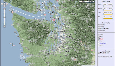
An important change has occurred during the past decade that many are not aware of: a huge increase in the number surface observations. Go back 20 years ago and there were perhaps 1000 regular observations around the U.S., mainly at airports. Roughly 30-40 regular observations over Washington State at primary and secondary airports.
In contrast, today there are certainly at least 100,000 surface stations that report hourly and distribute their data in real time via the Internet over the U.S., and several thousand such observations over Washington alone. In fact, there are so many observations available today, that if we plotted them all the weather maps would turn black with them over many parts of the Northwest. Here is an example from earlier this year--there are a lot more stations available now:
So what has happened to provide such a treasure drove of information?
First, there are many groups in the observing business right now...organizations that for whatever reason have established real-time observation networks. Some local examples: Seattle Public Utilities, the State AgWeatherNet, Washington State Ferries, Washington DOT, local private utilities, NW avalanche network, School Weather Networks associated with local TV stations, etc.---the list is long. And then there are hundreds, if not thousands, of Northwest residents that has purchased capable weather stations and made their data available in real time via the WeatherUnderground or similar online services.
Which gets to the other parts of the revolution: the availability of very good amateur equipment (like the Davis Pro weather stations) and the omnipresence of the Internet. So for a very modest investment one can collect excellent quality information and make it instantly available to the world (something impossible two decades ago).
At the UW we collect more than 70 networks in real time, quality control and archive them, and make them available to all of you at our web site, Here is a sample for Seattle right now (and our system does not plot every observation!):
Interestingly, there are some places where there is several stations within a half mile, while gaps remain in others.
This huge amount of surface data for the first time gives us insights into the local variations of surface weather features. And enhances our ability to do very short term forecasting---called Nowcasting. The national weather service also collects another of weather networks, through their MADIS system, and you can get at a lot of this information via their very nice web site:
http://www.wrh.noaa.gov/mesowest/gmap.php?map=sew
And this surface data revolution is just warming up. Some new smartphones take continuous pressure measurements (as a way of getting height)--can you imagine if that data was communicated to a central site in real-time? And it is matter of time before all cars have internet capability--imagine if each reported temperature and other weather parameters in real-time as they drive around. And there is more.
Although surface data is very useful, it is not enough. Meteorologists need 3D data to forecast the weather since we need to describe the atmosphere's entire volume to run our models into the future. And surface data often has problems--wind sensors placed behind an obstacle, temperature sensors too close to a building or not properly shaded; the potential issues are many.
Securing huge volumes of upper air data is another revolution...but one that will wait for a future blog.
This blog provides forecasts weather or other topics
Subscribe
Popular post
-
I didn't want to mention this, worrying I might jinx it, but it is clear that August 2012 will the driest in Seattle history. So far we...
-
Your plants know it, and so will your water bills if you have a garden. Over western Washington most places have not seen rain in roughly f...
-
Today was very warm around western Washington, with some stations (like Sea Tac ) breaking their all-time daily record. Now let me make one...
-
Wed Morning Update: The pressure differences across the mountains have weakened and the winds of Ellensburg have died down. Temperatures t...
-
Well, one thing a forecaster learns quckly is humility. There is a weak upper level disturbances that is causing this light precipitation. ...
-
It is not unusual during summer to view a satellite image like the following, with a narrow sliver of low cloud along the Northwest coast. ...
-
The front made it in late this afternoon and early evening as shown by the infrared satellite photo above. Winds really increased this afte...
-
Click on picture for Dale Ireland's time lapse movie of today's action. Its cold, windy, with heavy rain in places. Convective show...
-
A weak cold front is now moving into western Washington (see satellite and radar) imagery...with increasing clouds and a few light showers o...
-
A week ago I received an unusual call from Eric Swansen, Managing Director of the Regional Animal Services of King County. He had looked at ...
Blog Archive
-
▼
2011
(211)
-
▼
December
(15)
- Finding Sun
- Subtropical Moisture, Record Lost, and Thank You
- The Christmas Day Storm
- The Big Shift in Our Weather
- Where is La Nina?
- The Surface Data Revolution
- How is the snowpack doing?
- Drought
- Surface, Air, and Soil Temperatures: The Differen...
- Fog Outside, Desert Humidity Inside
- Amazing Fog Pictures and Inversions
- High Pressure Produces Low Sea Level
- Seattle's Math Secret Revealed (Revised)
- The Irony of Wintertime High Pressure
- History is Made: Highest Pressure in Sea-Tac Hist...
-
▼
December
(15)
Powered by Blogger.
Support :
Creating Website | Johny Template | Mas Template
Copyright © 2011. The Weather - All Rights Reserved
Copyright © 2011. The Weather - All Rights Reserved


