

We have also been observing another anomaly: the height of the water levels in the region have been unusually LOW, particularly along the Pacific coast. NOAA produces water-level predictions = (the tide tables we know so well) and these predictions are generally quite good, since we understand very well what produces tides and their periodicities. But recently the tide predictions have been greatly in error, forecasting tides that are much too high by one or two feet! Here is the predicted and observed water level at Neah Bay, provided to me by UW's Dr. Nate Mantua.

Turns out these two anomalies (high pressure and low water levels) are directly connected, with high pressure pushing water levels down.
The general term for this mechanism is the inverse barometer, and is often used to explain unusually high water levels when low pressure is over a water-covered area (see graphic)--and you may

remember that I wrote about this a few years ago when record low pressure spread over the west coast (click here for my past blog). In general, the water level should sink around 1 cm for every mb pressure increases. We have experienced about a 20 mb high-pressure anomaly, and thus one would expect water levels around 20 cm (8 inches) below normal.
However, there is something else going on here. The center of the high pressure has generally been offshore and as a result northerly winds have been persistent along the Northwest coast (see graphic from WRF model forecast):

Northerly winds put a force on the water to the south, but because of the Coriolis effect, there is an offshore component to the surface currents. Thus, surface currents are pulling water AWAY from the coast, further reducing the height of the water surface.
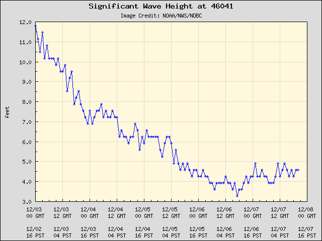
And it is better than that if you like low water levels. With a complete absence of storms there are no strong winds pushing water up on the coast and very weak wave action. Take a look at the wave heights along the Washington and Oregon coasts at two NWS coastal buoys for the past five days (46041 off of WA, 46050 off of Oregon). Waves progressively decreased to 4-5 ft. Good time for fishing?

We will be stuck in this pattern (high pressure, low clouds west of the Cascade crest, air pollution) for several more days, so you better get used to it. Want sun, head into the mountains or eastern WA or OR.
PS: If you want me to answer a question on-air on KPLU on Friday at 9 AM, you can leave it at this link.


