I didn't want to mention this, worrying I might jinx it, but it is clear that August 2012 will the driest in Seattle history. So far we have had a trace--which means a sprinkle that is less than .01 inches. (The National Weather Service defines measurable rain as rain of .01 inches or more.) The previous record was in 1974 when .01 inches had fallen.
The other record we working on is the longest stretch of dry days----for which the record is 51 days.
Right now we are at 38 days...which I believe is something like the 7th longest dry spell. But it is clear that we have at least 4-7 days of no rain ahead, so we will surely get into the mid-forties.
One of my favorite forecasting tool is from the output of the North American Ensemble Forecasting System (NAEFS), which combines the ensemble forecasts of the U.S. and Canadian forecasting efforts. Remember, an ensemble is when we run the models many times to get an idea of the uncertainty and probabilities in a forecast. Combining two ensembles is even better than using one!
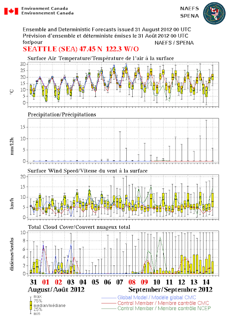
So here is the output from NAEFS (keep in mind this is all in metric). Temperatures are moderate (highs around 20C--68F), but then warm well into the 70s and low 80s, as a major ridge builds in next week).
But look at precipitation in the second panel. Nothing for the next week...so we should get at least to a 45 day dry streak. We will be in the top five at that point. Within striking distance.
Finally, today and this weekend we have some weak troughs over the area, bringing some morning low clouds and temps in the upper 60s to low 70s. Fine for outdoor activities. As the ridge revs up this week, highs will rise in the mid to upper 70s, perhaps 80s in some locations. My tomatoes are very, very happy.
The only issue will be wildfires. There will be no lightning, so that won't initiate them. But the landscape of the region is very dry. Consider the MODIS satellite imagery from yesterday: many fires (and lots of smoke) over Idaho, and several fires over CA.
This blog provides forecasts weather or other topics
Subscribe
Popular post
-
I didn't want to mention this, worrying I might jinx it, but it is clear that August 2012 will the driest in Seattle history. So far we...
-
Your plants know it, and so will your water bills if you have a garden. Over western Washington most places have not seen rain in roughly f...
-
Today was very warm around western Washington, with some stations (like Sea Tac ) breaking their all-time daily record. Now let me make one...
-
Wed Morning Update: The pressure differences across the mountains have weakened and the winds of Ellensburg have died down. Temperatures t...
-
It is not unusual during summer to view a satellite image like the following, with a narrow sliver of low cloud along the Northwest coast. ...
-
Well, one thing a forecaster learns quckly is humility. There is a weak upper level disturbances that is causing this light precipitation. ...
-
Click on picture for Dale Ireland's time lapse movie of today's action. Its cold, windy, with heavy rain in places. Convective show...
-
The front made it in late this afternoon and early evening as shown by the infrared satellite photo above. Winds really increased this afte...
-
A weak cold front is now moving into western Washington (see satellite and radar) imagery...with increasing clouds and a few light showers o...
-
A week ago I received an unusual call from Eric Swansen, Managing Director of the Regional Animal Services of King County. He had looked at ...
Blog Archive
-
▼
2012
(151)
-
▼
August
(18)
- The Driest August In Seattle History (and more to ...
- The Benefits of Tropical Storms and Hurricanes
- The Real Threat of Tropical Storm/Hurricane Isaac
- First Frost and Tropical Storm Isaac
- Sea-Tac Heat
- Want Warm Water--Get a Boat!
- Midsummer Drought?
- Escaping the Lightning Bullet
- New Wildfire Threat
- Can a major wildfire occur west of the Cascade crest?
- Why a heat wave may slow down the Cle Elum fire
- Lost Cats and Heat
- Extraordinary Asian Smoke versus the Perseid Meteors
- Climate Distortion
- Amazing Mammatus
- Mid-level Convection
- Is Algebra Necessary? Of Course It Is!
- Heat Waves and the Thermal Trough
-
▼
August
(18)
Powered by Blogger.
Support :
Creating Website | Johny Template | Mas Template
Copyright © 2011. The Weather - All Rights Reserved
Copyright © 2011. The Weather - All Rights Reserved


