
What is this benighted region, one in which Seattle TV stations often stage their camera crews for dramatic wind shots?
The answer: Northwest Washington...the region extending north and west of Everett, over northern Whidbey Island, to the San Juans and down to the NE tip of the Olympic Peninsula.
Why is this region so windblown? And why only certain directions? Why can the winds be blowing at gale force there, while Seattle is practically calm? I will try to explain in this blog. We have had a number of major NW Washington wind events this month and another will hit tomorrow (Sunday, 11/27).
 |
| Northwest Wind Land |
A mild event is going on right now (Saturday, 9 PM). Here are the winds:

Sunday morning things will really be blowing: here is the lasted WRF model forecast of sustained winds at 4 AM. Sustained winds of 40 kts (46 mph)...with higher gusts, of course.

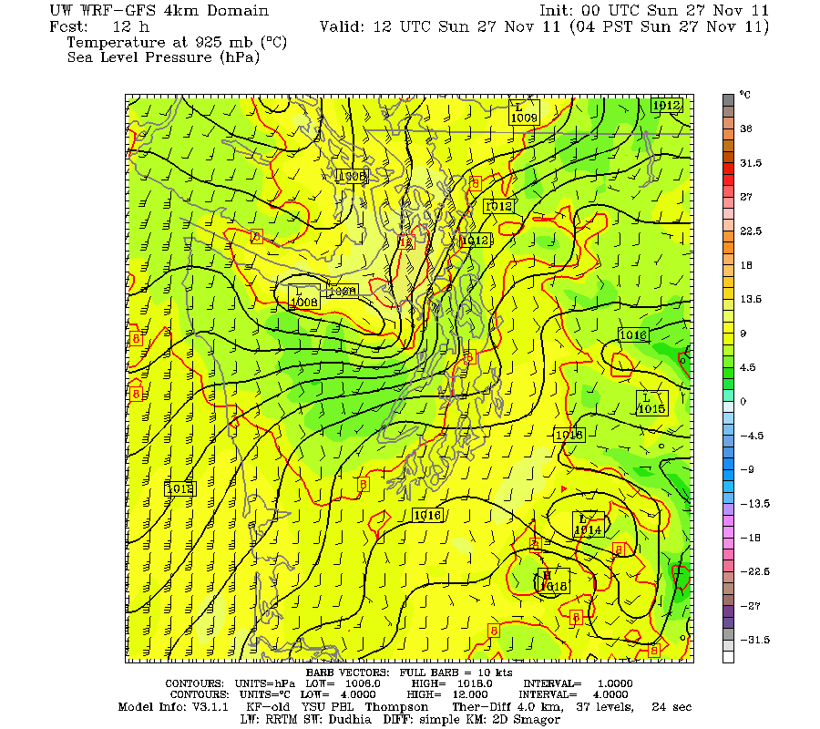
So why the strong winds? One reason is the extensive amount of water in the area and winds blow much stronger over water because it is aerodynamically smooth. But there is something else....the OLYMPICS!. The mountains distort the local pressure field, with pressure being increased on the windward side and decreasing on the leeward side. The winds in these situations are almost always from the south...thus there is high pressure on the southern flanks of the Olympics (rising air causing cooling and cool air is more dense and thus results in higher pressure) and lower pressure (leeside trough) on the northern side where air sinks and warms by compression. Here is a graphic of the situation at the same time as the previous figure...the lines are isobars (lines of constant pressure) and the wind barbs are shown too. See the distortion of the isobars by the Olympics? Nice lee low by Port Angeles and Sequim. Do you see how the distortion caused the isobars to bunch up from roughly Everett to Whidbey Island? Such a large change in pressure is called a large pressure gradient. That causes the winds to accelerate greatly as the air moves from higher to lower pressure....and is the essential cause of the strong winds observed tonight and on Sunday....and many other times!
You need good southerly flow approaching the Olympics to get this effect...and such southerlies often precede a strong front or accompany an approaching low that is headed to the north of us. In fact, when a low goes north there is a background south to north pressure difference that can really add to the strength of the southerlies forced by the Olympic effect noted above. Here is a larger scale view of the pressure situation tomorrow at 4 AM... a strong front IS approaching.

Just to show how windy Smith Island (just west of Whidbey Is) can get, take a look at he recent max gusts there. Lots of 35-40 kt gusts the last day and nearly 60 kts on the 24th.

But wait until tomorrow morning! You can check the winds yourself at this site:
http://www.ndbc.noaa.gov/maps/NW_Straits_Sound.shtml


