A lot of the rain is still yet to come, but consider the rainfall of the last 48h as shown in our RainWatch site:
Some values in the southern Cascades reaching 8 inches according to the radar. Several raingauges there have reported 5-6 inches over the past 24 hr.
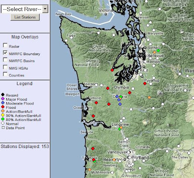
The National Weather Service is now predicting flooding on several rivers, some with moderate flooding, as seen by this figure from their website:
A particular threat is for the Chehalis River, where moderate flooding is predicted--although there is lots of rivers flooding over southwest WA and NE Oregon. Even the Snoqualmie is getting to bankfull. The Skokomish always floods...but that is another story.
A few of you have commented that this seems too cool for a pineapple express event and you are right. This is not a classic pineapple express event in which warm, moist air feeds up from deep in the tropics and subtropics. Temperatures are far more moderate and a look at the cloud shows that moisture is streaming from the southwest but not down to the vicinity of Hawaii (see picture). In fact, some of the moisture can be traced back far, far to the west--perhaps we should call it the Sushi Express.
But the other story here is wind and we have had some amazing winds...including 97 mph at Mt. Hebo in the Oregon coastal mountains, 70 mph at Bellingham, 70-85 mph on the Cascade crests, and 60-70 mph gusts all along the Washington and Oregon coasts. But the big action is about to happen over the Oregon coast, where the WRF high-resolution model is going for sustained 50 kt winds tonight, with higher gusts (see graphic). If you are on the Oregon coast, you better get some batteries.
 | |
| Forecast winds at 1 AM Wednesday |
The models have really been good--getting the timing and major features correct.
And did I mention the over a foot of snow in the mountain passes today and more over the North Cascades. With high to extreme avalanche danger as all this wet heavy snow falls on the light snow with embedded weak layers. This is really a good time to be a local weather lover...more action than one can keep track of.


