
There ARE some interesting climatological aspects of this weekend...so lets check it out. Here is a plot of the climatological probability of measure precipitation at Sea-Tac Airport. (click to expand)
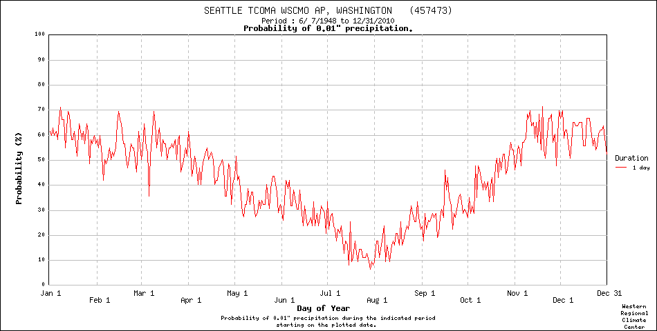
You can see that during the latter part of June we are locked into roughly a 27% chance of rain and that this value holds into the July 4th weekend. But then the Northwest magic occurs, during the next two weeks the chance of precipitation plummets roughly in half (approximately 14%) and then by the of the month it is less than 10%. We become, amazingly enough, one of the driest places in the U.S.!
Don't believe it? Here is the probability of precipitation at Phoenix, Arizona--their chance of rain is over ten percent in late July...in fact it is close to 20%! So you want to escape showers in mid-summer, Seattle is the place to be! What does Arizona have they we rarely have during this period? Thunderstorms. Anyway, if we still had a state tourism office, this would be a major reason to visit the NW in the summer--drought.

During the past 63 July 4ths, 18 had measurable precipitation (more than .01 inches) at Sea-Tac with largest being 0.57" in 1992. 13 July 4's had a trace. So...roughly half of the July 4ths at Sea-Tac has some wet stuff coming out of the sky!
Beginning with today, here is the latest visible satellite image. Most of the region is clear except of the NW part of Washington State and southwest BC. Radar shows a few residual showers--these clouds should progressively lift northward and dissipate later in the day. So for most of us, a very pleasant Friday with temperatures rising into the upper 60s and lower 70s. Take a hike if you are off today!

Saturday will be even better and clearly the best day of the weekend...full sun and temperatures in the lowland rising into the lower to mid 70s as a weak ridge builds over the region. Want real warmth?--head to eastern Washington where mid to upper 80s will be found.
But then things will go downhill. A weak Pacific front will push through Sunday morning, bring clouds and some showers. (see forecast map of 24-h precipitation ending 5 AM on Monday).

The worst conditions will be on the western slopes of the Cascades and in the Puget Sound convergence zone over the north Sound. If you are planning to go camping--be prepared for some showers. And temperatures will drop back into the 60s on Sunday. But you can escape this murk and rain...head to eastern Washington and Oregon, or south of Eugene, Oregon. The lower eastern slopes of the Cascades will probably be quite decent as well if you really want a hike.
And then there is July 4th. There should be some residual clouds in the morning, but they should evaporate during the day for a generally sunny afternoon and evening, with temperatures rising back into the lower 70s. Warm, dry conditions continue into Tuesday and Wednesday.
Finally, there was a question about taking a distance-learning class in meteorology at the UW. We do have one:
and those of you who really are gluttons for punishment, I am teaching Atmospheric Sciences 101 in the autumn. Anyone can register as a non-matriculated student and the UW also has very good deals for retired folks. Enjoy the fourth.


