Why is it so hard to forecast lowland snow?

| comments

Meteorologists can get windstorm forecasts right nearly all of the time.  We hit the record high temperatures in July 2009 nearly dead on.  We can give you a skillful forecast of a marine push in the summer.

But snow forecasts, although improving, are often in error.

Why?   Well, there are reasons....a lot of reasons.


(1) You've got to get the amount of precipitation right--really right-- or you have a very bad snow forecast.  On most days, the forecasts hardly talk about the amount of precipitation, just the probability of precipitation.   Most people don't care whether .1 inch or .4 inch of precipitation falls...they would hardly notice it.  But a difference like that would be HUGE for a snow forecast.  Around here there is typically a 10 to 1 ratio of snow versus precipitation in the form of liquid water.  Thus, .1 inch of precipitation would be .1 inch of rain or, if cold enough, 1 inch of snow.  (Precipitation is always reported in terms of liquid water--so snow has to melted before measuring it).  So the difference between .1 and .4 inches of precipitation, which you would be oblivious to of if it were rain, would be the difference between 1 and 4 inches of snow.  That you would notice.

Getting the amount of precipitation exactly right is very hard, much harder than getting the probability of precipitation correct, thus making the snow forecast difficult.  I can tell you why in a future blog.

(2)  But it is worse than that.  The majority of time our temperatures are marginal for snow...we are right on the edge of rain or snow.  The reason...all the warm water (e.g., the Pacific and the Sound) close by.    On most days a few degree error would not even be noticed (like the difference between 58 and 61F), but that is a big error on marginal snow days.  It is very hard to reduce the error under a few degrees.


(3)  But it is even worse than that!   The temperature of the air is affected greatly by the evaporation and melting of precipitation.  And that is dependent on the intensity of precipitation and the relative humidity of the air below!   Remember:  virtually all of our precipitation starts as snow.  Usually it melts before it reaches the ground, but if the intensity is great enough, the evaporation and melting of the snow can cool the air below so that the freezing level (0C) and snow level (about 1000 ft below the freezing level where all the snow does melt) progressively head towards the surface.  So we need to get the intensity of precipitation right, the initial freezing level right, the relative humidity of the air below the precipitating clouds right....you get the message.  And this is hard.

(4)  And there is more.  To get the depth of the snow right, you also need to know the characteristics of the snow--is it dense or light?  That depends on crystal type and temperatures, which can cause the ratio to vary from 5 to 1 for wet snow to 20 to 1 for dry stuff.

(5)  There is another problem.  Snow is so infrequent and takes such unusual conditions to occur that meteorologists have less practice and experience that for more typical weather.  Why unusual?  Well, it is easy to be warm and wet around here (warm being in the 40s and 50s) for air coming off the Pacific,  pretty easy to be cold and dry (when we have high pressure over or to the east of us).   But it takes a lot of doing for us to be cold and wet.  The set up has to be just right.  Meteorologists are like anyone else:  you gain skill with practice.   Only old timers have lots of cases in their heads...and even that is not good enough since the modeling and observation systems have changed so much.

(6)  Still think it is easy to forecast snow?   Well, local meteorologists have more problems to deal with: a multitude of local effects.  The potential for snow is generally much less near local water bodies, particularly near sea level.  Chances increase greatly up on hills...even 200-300 ft can make a world of difference.   We have gaps that allow cold air to move through the mountains (like the Fraser River gap allowing cold air into NW Washington).  Convergence Zones (like the Puget Sound convergence zone) produce areas of enhanced precipitation and sometimes snow.   And their are dozens of local effects I haven't mentioned.

You get the picture.  Snow prediction is hard, real hard, particularly around here.   Forecasting winter snow back east,  say in  North Dakota, is a cake walk---you KNOW is will be cold enough.  Huge simplification.

So unless you are a Subaru advertising executive....have a little sympathy for the poor NW weathermen when a snow forecast goes wrong.  And keep in mind, a lot more technology is coming:  ensemble-based snow prediction, better use of the new dual-polarization radars, and more.  Meteorologists will make progress....and then we can attack even harder problems, freezing rain and shallow fog.

Major Storm Hits

| comments

This storm has so many interesting and intense features I just wanted to update everyone on the action.  Here is the latest infrared satellite photo--simply impressive.  You can see the swirling clouds around the low center, which is now crossing northern Vancouver Island...exactly what the models have been saying for a few days.  Cold unstable air is circling around from the west (the pattern of cloud and clear skies that has a mottled appearance). 

It appears that last night's runs underpredicted the strength of the system a bit...the pressure at Solander Island, on the northern Vancouver Island coast dropped to 962 hPa.  This is a very intense low for our neck of the woods.  The more intense storms on record only get down to the low 950s.

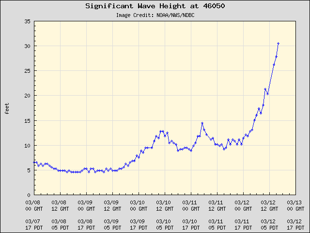
And the wave heights did not disappoint.  Some of the buoys have shown significant wave heights of over 30 ft!  Here are a few examples at buoy 41 off the WA coast and buoy 50 off the Oregon coast:


As I noted in previous blogs, the NWS Wavewatch III model indicated the potential for a big wave event...it was correct.

By the way, if you ever want to check out coastal conditions a really great site is SurfWA.

And the Langley Hill radar on the WA coast provided its value again, indicating the approach of the front from offshore.  Look at radar image from around 6 AM this morning...the front is seen offshore...the line of convection that has a series of intense elements (cores) and weaker areas (gaps).  Classic ocean frontal signature.   And by tracking it we knew exactly when this key feature was going to make landfall hours ahead (more on this in a future blog).


 And winds?  On the coast, winds of up to 50-70 mph were commonplace, such as the 60 kts at buoy 41 off the central WA coast:


More impressively, we are experiencing one of the strongest wind events of the past few years over NW Washington and SE Vancouver Island.  Winds at Trial Island, just off of Victoria have gusted to at least 60 knots (69 mph).  Buoy 88, over the eastern side of the Strait to 50 kts (see below)


Winds are fairly strong (30-40 mph) over Puget Sound, but weaker over land.   Here are the 7 AM winds from the Kingston Ferry...winds (sustained) to 36 knots. Note how much weaker the winds are closer to the shore where they are coming off of land.  Water is aerodynamically fairly smooth and allow strong acceleration.

Anyway, an impressive storm and well predicted.   It is perhaps ironic that we have gotten so good at predicting major Pacific storms coming off the ocean, yet have so much trouble in getting minor snow events correct.  Twenty years ago we were unable to forecast major cyclones coming off the ocean...we not only can do that now, but have great skill in determining the resulting  local wind patterns.  Two decades have changed everything.  Don't forget that when you listen to a weatherman jokes or view a Subaru commercial ("you don't need a weatherman if you have a Subaru").

Storm Update

| comments

Its showtime.   The coastal storm is now rapidly intensifying offshore and winds are increasingly over the coast and over NW Washington.  The latest runs indicate a similar path as previous model forecasts, with the low crossing the northern portion of Vancouver Island.  But the storm is now forecast to be weaker by about 10 hPa (the low is now predicted to be in the low 970s as it makes landfall, instead of the low 960s).   Still a serious storm, but a significant notch lower in intensity.

Here is the latest infrared satellite image. You can see the developing storm with a cloud free notch on its western side...the low center is near the apex of that notch.

We also have water vapor imagery (I rarely have shown this on the blog).  At this wavelength we are seeing atmospheric water vapor, with the dark areas indicating dry conditions in the upper troposphere.  Such darkening is a good indicator of rapidly developing systems.


 Along the coast pressure is falling and winds are rising to 40 kts and more.  To illustrate here are the pressure and wind observations at buoy 46041 off the central Washington coast.

Here is the forecast sea level pressure chart for 4 AM this morning. 975 hPa low moving northward off our coast and intense coastal pressure gradients.


We still expert big winds over northwest Washington, particularly the western side towards San Juan Island and Victoria.  Here is the sustained wind forecast for 8 AM tomorrow (Monday) morning.  The dark blue are winds of 45 kts and there are even red (50 kts).  Strong, but lesser winds, over Puget Sound.  These are very intense conditions for the inland waterways.  Gusts will be higher.


The coast will get hit hard around 3 hrs earlier.   Here are the sustained winds at 5 AM--very strong winds along the coast (50kt sustained and higher).

The NWS Wavewatch 3 model is still predicting waves of 8-9 meters (roughly 25 ft)...see chart below for 8 AM Monday.


With low pressure (which results in higher water level) and high tides at 4-4:30 AM, water levels will be quite high during the morning.  If you are going storm watching on the coast, keep safe--some coastal areas will be inundated and logs can be thrown around by the turbulent waters.

And did I mention the moderate to heavy rain over the lowlands and heavy snow in the mountains (over a yard of the white stuff in the Olympics for example).

Major Coastal Storm

| comments

Forget the snow showers and other minor weather annoyances.   We got bigger fish to fry.   A major cyclone will rapidly develop on Sunday and then move northward off our coast, crossing the northern portion of Vancouver Island.  A storm that will produce very strong winds and substantial waves along the Northwest coast, but pass far enough out to lessen the the threat of a major windstorm over most of the interior.

Here is the latest UW WRF forecast (12km domain) for 7 AM on Monday.  Most of the major modeling systems...including the ensemble systems...agree with this solution, so there is a good chance reality will be similar.  A very strong low center of 963 hPa, with intense pressure gradients around it.  Large gradients down the Strait and along the Oregon coast as well.  Shift this low 150 miles to the east and we would have real problems over Puget Sound.


Here is the forecast SUSTAINED wind speed (in knots) at the same time. 50 kts along the coast and well over 50 knots south and east of the low center.  That area is sometimes called the "poisonous tail of the bent-back occlusion."


Lets examine a zoomed in section for western Washington:  you can see there will very strong winds over NW Washington, particularly towards Victoria.  I don't know whether I would take the Victoria Clipper on Monday! (I bet they cancel). 50 kts and more (red) along the Washington coast.


As the low approaches Vancouver Island, the winds along the northern third will be extreme, with hurricane force gusts.  Here is the forecast at 10 AM Monday.  Wow.  Solander Island may well see winds over 100 mph.


Keep in mind that the low could shift east or west a bit from this forecast..but probably not much.

Of course, such a fierce storm will kick up substantial waves, although the rapidity of its development and its quick motion will work against the really big stuff.  Remember big waves require strong winds, with large fetch and long duration.  We have the first, but lack a bit in the second and third.  Here is the forecast from the NWS Wavewatch III model for Monday at 1 PM.  8-9 meter (26-29 foot) waves along the coast.  Not a good day to be fishing out there.  But a good one to head to the shore to watch big waves and to thrill in the winds. (Editorial Comment: I still believe we undervalue the value of storm tourism along the coast--and the attraction of a storm, tsunami, and shipwreck museum out there.  The coastal hotels and B&Bs should be packed on Sunday night with people ready to experience a big storm.  Why head to Oklahoma to see a tornado when you can view something grander and lots more dependable).

The amazing thing is that we can predict such storms.  Essentially it hardly exists now, and on Sunday it will develop explosively....we call such storms meteorological "bombs."   Here is a surface map (isobars...lines of constant pressure at the solid lines, colors are temperature) at 1 PM on Saturday and every 12 hrs so you can appreciate how quickly this event forms out of a minor trough:


Right now the incipient trough is WEST of the tip of the Aleutians.  Its extraordinary we can make these predictions...and be right so often.

And did I mention snow?  The mountains will get around a foot today and Sunday and several feet on Monday and Tuesday with this system.  No water problems for us next summer!

Lenticular Clouds

| comments

Spectacular Lenticular Cloud Downstream of Mt. Rainer taken by John Caldwell
A close up by John Caldwell:
My discussion of the weekend weather and lenticular clouds is found at KPLU: http://www.kplu.org/)

Today there were wonderful displays of lenticular clouds (a.k.a. mountain wave clouds) downstream of both the Olympics and Mt. Rainier.    In addition to the stunning picture by John Caldwell shown above, I have included a few others for your viewing pleasure.   First one from the cam on top of my building, facing towards the Olympics:

Or one downstream of Mt. Rainier, again from my building:


A far better picture taken by Kevin Freitas in Tacoma was found online at this website:


You could see these lenticular clouds from space as viewed in the high-resolution visible satellite photo right before sunset.

And here is one from Dale Ireland's famous cam in Silverdale:


Why do we get such features?  They occur when air, often near saturation, approaches a mountain barrier.  Pushed up by the mountains, the air goes into an oscillation, with the waves propagating both downstream and upward.  Here is a schematic of the process:


The clouds are often lens shaped because that reflected the vertical velocity patterns produced by the mountains.  And there are often multiple plates or disks when there is structure to the moisture profile.

To see what the air approaching our region looked like today, here is a vertical sounding at Quillayute, near the Washington coast at 4 PM today.  Red is temperature and blue indicates dewpoint.  The closer they are the near to saturation the air.  The numbers of the left indicate  pressure (500 is roughly 18K feet, 700 around 10K feet, etc).  The air is close to saturation above 18K feet, with winds from southwest.   Good situation for lenticular clouds.

Did the super-hi resolution WRF model (4/3 km resolution) simulate these clouds?  You know the answer!  Here is the simulated cloud field at 4 PM.  You see a veil of high clouds with the mountain wave clouds embedded in them.   Pretty impressive forecast (12 h ahead).

Finally, if some of you are VERY lucky you might sneak a peek of the aurora tonight...but its a race against the approaching clouds.

Will You See the Aurora Tonight?

| comments

I have gotten several emails about this, so let me provide some brief guidance.  The short answer:  probably not because of clouds.

There was a major solar event yesterday and with clear skies several of you saw a nice display last night.  In fact, Greg Johnson has captured last night's event on his web cam video (click on image to see video)


The event peaked last night and based on the Kp index, seems to be declining (see graphic). 


According to the guidance from the NOAA Space Weather Center, another solar event should cause a new peak in the Kp index sometime tonight (sometime after 10 PM):  Here is their latest forecast (in GMT--subtract 8 hrs for PST):

As shown from the graphic below, it needs to reach the 5-7 level for us to see much--something they are predicting for tonight.


But there is a problem for us...skies around here are no longer clear...we are getting considerable high clouds coming around the offshore ridge.  Here is the latest infrared satellite picture:


You see the problem.

The weather prediction models also forecast clouds and here are the simulations of what a satellite image would look like at 1 AM and  4 AM.  Yes, there are thin, high clouds in the forecast.  Better if you go south and east...but going south gets you away from the aurora.


Maybe we will luck out...there will be a thin spot in the clouds.  Viewing a good aurora is an amazing experience.

A Potential Source of K-12 Science and Math Teachers

| comments

 I have an idea...tell me whether its crazy.

The U.S. has a substantial problem with securing enough K-12 teachers with good knowledge in STEM (Science, Technology, Engineering, and Mathematics) subjects (one study of this problem).  This problem extends from a shortage of highly educated high school math and science teachers, to elementary school teachers with poor backgrounds in math and science.

Schools like the University of Washington have large numbers of students in STEM subjects, including students in my field, atmospheric sciences.  Even the weaker students in our STEM majors have stronger science and math backgrounds than many K-12 teachers.


Believe it or not, many of these UW STEM majors are NOT finding jobs in technical areas.

So, my question is:  wouldn't it be a REALLY good idea to facilitate the entrance of interested UW STEM majors into K-12 teaching?

I am undergraduate adviser in my department and I asked our undergraduates whether any would be interested.  I was blown away by the response...nearly a half dozen were enthusiastic about the possibility...and we are a very small department.

I talked to a few chairs of science departments--I received very positive feedback.

Sounds good so far, right?

Next, I checked with the UW College of Education.  It turns out that there is no program at the UW that will allow a non-education undergraduate major to get a teaching credential as an undergraduate

 I sent a few emails over to the leadership of the College of Education and they invited me over to talk.  I was told that the only path now for an educational credential for a STEM major is to return to the UW AFTER graduation for a fifth year as part of their Masters in Teaching (MIT) program.

I check with about a dozen students...having to pay for a fifth year is a real turn-off for them, considering the high cost of education right now.  Lets face it, you don't make big money in teaching for paying off debts.  They really want to do the whole thing in four years. 


So I suggested the following to the UW College of Education.  Let us establish a program whereby STEM majors would take education courses and do student teaching in their senior year (or distribute this over the last two years if possible).  STEM departments might have to make some adjustments (perhaps reducing our requirements a bit), but this is completely doable.  Students would receive both their STEM degree and teaching credentials after four years.  Let me be a bit controversial here...if the UW and other Ed Schools are ok with Teach for America, where students are given FIVE WEEKS of ed training before thrown into a classroom, surely they could work something out if they have an undergrad STEM major for a whole year.

I believe such a hybrid STEM/education program would be a huge success and could grow to hundreds of students.  The folks in the College of Education are willing to consider this idea, but noted they would need resources to create such a new program.  This would be money very well invested.  They told me they would hold a meeting on this subject sometime during the spring.

Is this a good idea?  I did some googling and found that several states have started or will start such a program.  It would help supply very qualified high school math/science teachers and could greatly improve the math/science backgrounds of elementary and middle school teachers.  To me this would be a home run for everyone involved and could be another way for the UW to contribute to our state.

Double Convergence Zone and Snow Hits the Area!

| comments

As last night's run correctly forecast, the front did not bring any snow to the lowlands.  As noted yesterday, it was a really interesting situation in which a small change in the configuration of the front caused a huge change in the snow prediction.  An indication of how snow often requires getting everything right around here, particularly when temperatures are marginal.

But we did get some snow today  after frontal passage and in fact it is snowing over NW Washington as a write this blog.

Today, as the front moved past, the winds turned northwesterly on the coast--the direction that sets up the Puget Sound convergence zone.  Did you know that convergence zones are often double?   One in the lee of the Olympics and the other in the lee of the mountains of Vancouver Island?   Here is a nice visible satellite shot today that shows this clearly:

You will also notice how CLEAR is it north and south of the convergence zones...that is due to air sinking down the slopes of the two barriers.  The picture also clearly shows the retreating front, stretching from the north Cascades across NW Oregon.  You can also see the double convergence zone in the surface winds:
 Here is the radar image at 1 PM:  you can see the convergence zone and some of the frontal precipitation.


The air cooled down behind the cold front and in the areas of heavier precipitation within the PS convergence zone melting and evaporation pushed the snow level down to the surface.  You can see some of the convergence zone cooling in this plot from Seattle SNOWWATCH at noon...mid-30s in Mountlake Terrace and Lynnwood within in the convergence zone precipitation zone.  Ten degrees warmer to the south.
Within the convergence zone many saw snow showers and then continuous snow--up to an inch in places.   Here is the proof from WSDOT cameras:


The image looks like the arctic!


Tonight the convergence zone has weakened, but a band of showers is moving across NW Washington--with lots of reports of snow, freezing rain, and ice pellets.  Enough to melt the crystalline heart of the Salt Guru.  Here is the radar image and a snowy shot from a Bellingham cam to show what is happening.  Some snow showers will continue across the region into mid-mrning and then end for the day over the lowlands.


Dog Spotted Again: A report by someone last night at Horizon View Park in Lake Forest Park.   Another person claimed to see our dog, all trimmed and cleaned up on someone's leash at the playground at Terrace Creek Park

 
Support : Creating Website | Johny Template | Mas Template
Copyright © 2011. The Weather - All Rights Reserved
Template Created by Creating Website Published by Mas Template
Proudly powered by Blogger