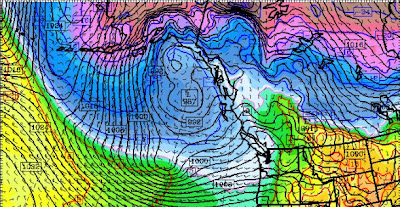
Here is the latest UW WRF forecast (12km domain) for 7 AM on Monday. Most of the major modeling systems...including the ensemble systems...agree with this solution, so there is a good chance reality will be similar. A very strong low center of 963 hPa, with intense pressure gradients around it. Large gradients down the Strait and along the Oregon coast as well. Shift this low 150 miles to the east and we would have real problems over Puget Sound.
Here is the forecast SUSTAINED wind speed (in knots) at the same time. 50 kts along the coast and well over 50 knots south and east of the low center. That area is sometimes called the "poisonous tail of the bent-back occlusion."
Lets examine a zoomed in section for western Washington: you can see there will very strong winds over NW Washington, particularly towards Victoria. I don't know whether I would take the Victoria Clipper on Monday! (I bet they cancel). 50 kts and more (red) along the Washington coast.
Keep in mind that the low could shift east or west a bit from this forecast..but probably not much.
Of course, such a fierce storm will kick up substantial waves, although the rapidity of its development and its quick motion will work against the really big stuff. Remember big waves require strong winds, with large fetch and long duration. We have the first, but lack a bit in the second and third. Here is the forecast from the NWS Wavewatch III model for Monday at 1 PM. 8-9 meter (26-29 foot) waves along the coast. Not a good day to be fishing out there. But a good one to head to the shore to watch big waves and to thrill in the winds. (Editorial Comment: I still believe we undervalue the value of storm tourism along the coast--and the attraction of a storm, tsunami, and shipwreck museum out there. The coastal hotels and B&Bs should be packed on Sunday night with people ready to experience a big storm. Why head to Oklahoma to see a tornado when you can view something grander and lots more dependable).
The amazing thing is that we can predict such storms. Essentially it hardly exists now, and on Sunday it will develop explosively....we call such storms meteorological "bombs." Here is a surface map (isobars...lines of constant pressure at the solid lines, colors are temperature) at 1 PM on Saturday and every 12 hrs so you can appreciate how quickly this event forms out of a minor trough:
Right now the incipient trough is WEST of the tip of the Aleutians. Its extraordinary we can make these predictions...and be right so often.
And did I mention snow? The mountains will get around a foot today and Sunday and several feet on Monday and Tuesday with this system. No water problems for us next summer!


