

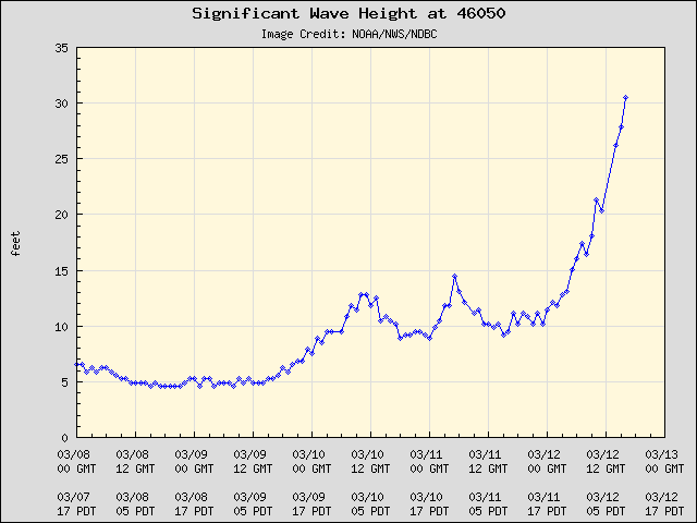
And the wave heights did not disappoint. Some of the buoys have shown significant wave heights of over 30 ft! Here are a few examples at buoy 41 off the WA coast and buoy 50 off the Oregon coast:

By the way, if you ever want to check out coastal conditions a really great site is SurfWA.
And the Langley Hill radar on the WA coast provided its value again, indicating the approach of the front from offshore. Look at radar image from around 6 AM this morning...the front is seen offshore...the line of convection that has a series of intense elements (cores) and weaker areas (gaps). Classic ocean frontal signature. And by tracking it we knew exactly when this key feature was going to make landfall hours ahead (more on this in a future blog).


More impressively, we are experiencing one of the strongest wind events of the past few years over NW Washington and SE Vancouver Island. Winds at Trial Island, just off of Victoria have gusted to at least 60 knots (69 mph). Buoy 88, over the eastern side of the Strait to 50 kts (see below)

Winds are fairly strong (30-40 mph) over Puget Sound, but weaker over land. Here are the 7 AM winds from the Kingston Ferry...winds (sustained) to 36 knots. Note how much weaker the winds are closer to the shore where they are coming off of land. Water is aerodynamically fairly smooth and allow strong acceleration.

Anyway, an impressive storm and well predicted. It is perhaps ironic that we have gotten so good at predicting major Pacific storms coming off the ocean, yet have so much trouble in getting minor snow events correct. Twenty years ago we were unable to forecast major cyclones coming off the ocean...we not only can do that now, but have great skill in determining the resulting local wind patterns. Two decades have changed everything. Don't forget that when you listen to a weatherman jokes or view a Subaru commercial ("you don't need a weatherman if you have a Subaru").


