
Here is the latest Forest Service map of fire incidents over the region--all of the them are east of the Cascade crest, mainly in Oregon.


The most prominent smoke plume is not from the largest fire-- the High Cascades fire, which is now encompassing over 100,000 acres near Madras, Oregon--but from the Dollar Lake fire, 16 miles south of Hood River (roughly 3000 acres). The winds are clearly from the east and you can see the smoke plume moving WNW towards Portland. If you look carefully you can see the smoke from a small fire over the Olympics.
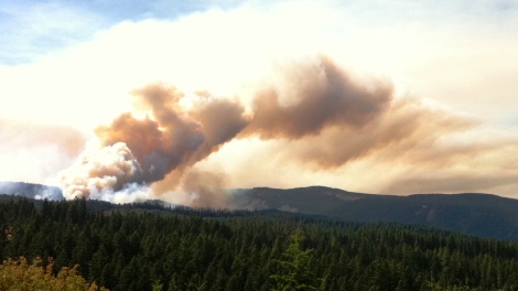
Here is a nice shot of the smoke from north of the Gorge looking south and another near Mt. Hood.

Both of these fires were initiated by lightning strikes.
The local wildfire problem is probably going to get much worse during the middle and end of next week. No rain is in sight and after a minor cooling on Monday and Tuesday, the heat should really rev up mid-week as the ridge over the western U.S. greatly amplifies into a huge atmospheric blocking pattern. Here is a sample forecast for next Wednesday...wow. And there is no end in sight.

West of the Cascades we should see the entire region (away from the water) moving into the mid-80s, with a number of daily high temperature records falling.
A major concern is that the burnable surface materials ("the fuels") are drying out rapidly. Here is a Forest Service figure showing you the moisture content of the "1000-hr" fuels---the bigger, thicker branches and debris. Darker red indicate seriously dry fuels and this is only going to get worse.


In short, we are going into one of the warmest September periods we have experienced in a long time and fire danger is getting serious. The only good thing is that there won't be much lightning.


