
Here is the storm total precipitation ending 10:30 AM on Monday from the new radar....notice the enhanced precipitation on the windward (SW) slopes of the Olympics:

In science, major advances in understanding often come with a new instrument, one that casts light on a previously unobserved phenomena. Certainly, that is true of meteorology; through new understanding and additional data from new sensors, the skill of prediction increases.
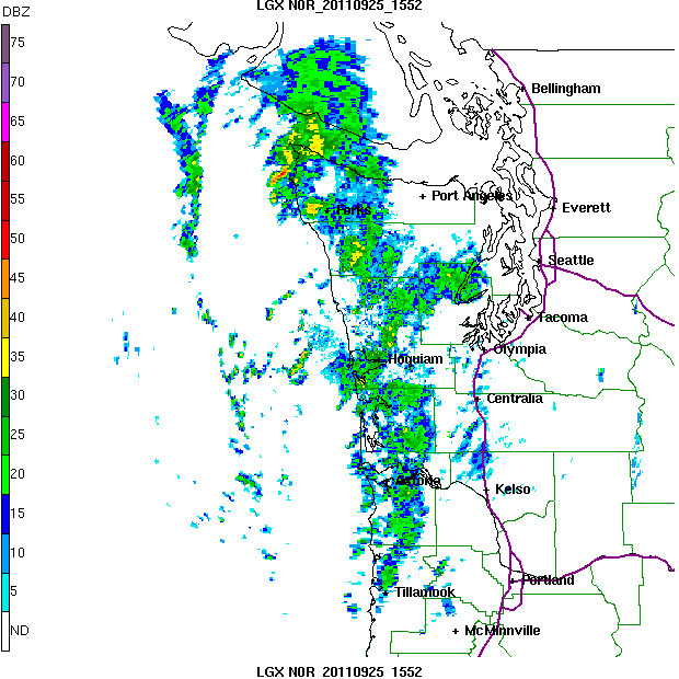
The frontal system that passed through during last night and today was observed from beginning to end by the new Langley Hill radar---lets take a look at only one viewpoint: the reflectivity at the lowest elevation angle (.5 degrees). As we have talked about many times in this blog, such reflectivity is closely related to precipitation intensity.
First, consider the image at 5:34 PM yesterday. Note the precipitation intensity (reflectivity) is given in dbz and yellow is very heavy stuff, green a lot lighter, etc. Looking offshore we could see the approach of the Pacific frontal system (something we could not do before). During the day yesterday (Saturday) the skies over Puget Sound clouded up and some light showers formed as the air over the western interior destabilized at midlevels--producing lots of altocumulus castelanus. You can see the light showers in the radar, indicated by the north-south linear features. Not forecast well. This was not frontal precipitation, but rather the instability was initiated by the approach of the upper level trough associated with the front.

Four hours later around 8 PM the offshore precipitation was approaching rapidly and some light showers remained over the western slopes of the Cascades,

As the evening progressed the band reached the coast, as shown by this image at 1:44 AM. Look how nicely the radar shows the band from Vancouver Island to south of Tillamook, Oregon. The location of this radar was chosen very, very carefully to allow such a comprehensive view. Behind the band the precipitation is spottier and more intense, indicative of convective precipitation.


 ?
? And finally the situation after the front around 5 PM on Sunday...a few convective showers over the Pacific. Showers and sunbreaks.

Seattle School Board Candidate Events
There are two important gatherings to listen and talk to Seattle School Board candidates:
Wednesday, Sept 28th-7:30pm
The Stranger's School Board Candidate Debate
Town Hall - 1119 8th Avenue, Seattle
NOTE: The event is FREE but tickets are required.
Click here for ticket information.
Friday, September 30th 6-8pm
West Seattle Meet & Greet Happy Hour with Candidates Marty McLaren & Sharon Peaslee (and I will be there too!). Refreshments, of course.
TOPIC: Improving Math, Science and STEM in SPS
7020 18th SW (north of SW Myrtle)
Donations appreciated. - all are welcome


