
 Today, was the first day since mid-February that we reached the normal high....three weeks! February was the seventh coldest at Sea-Tac since 1948. I suspect that if we looked at the period from Feb 15 though March 7th, it would be in the top three cold years at this location.
A series of storms is now on tap and the first one is off our coast. Here is nice infrared satellite image this evening.
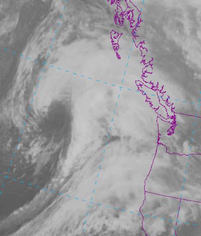 Infrared (IR in the business) pictures tell us how much infrared radiation the earth and clouds are radiating in a certain wavelength range in which the atmosphere is relatively transparent (called a window region). For IR images the wavelengths observed are typically 10-12 microns.
Cold clouds are shown as white, warmer objects dark. Since temperature usually decreases with height, cold clouds are generally high and vice versa, so we can tell the height of clouds with such imagery.
You see that well defined hook? The low center at the surface is right in the middle of this. And the cold front is associated with the long narrow cloud feature extending to the south.
This low center will move up the coast west of Vancouver Island..so no major windstorm here.... (see graphic for pressure pattern at 10 AM tomorrow)...
 but there is another behind it for Thursday and this one is coming in much closer. Strong winds are in the cards with the next system. Remember the general rule of thumb: to get strong winds over Puget Sound the low center must cross the coast between the NW tip of the Olympic Peninsula and the middle of Vancouver Island.


