
There have been some complaints about the recent snow forecasts in some quarters. The Seattle Times will run a story tomorrow "Forecasts for Snowfall in Seattle Goes Cold", several of you have commented about poor snow forecasting of this event, and even one prominent local TV weathercaster noted that sometimes he has to admit to making a mistake (about the snow over Seattle) and then proceeded to blame it on the models (and showed the UW model output for good measure!). Let me give you my take on this.
Before we evaluate the forecast, what actually happened. Well, the region did get snow and some locations a lot of it. Based on the official National Weather Service numbers, the heaviest snow (up to .5 to 1.5 feet) fell in a line stretching from Skagit County across Whidbey Island out to Victoria. On the northern Olympic Peninsula Sequim had 4.5 inches,Port Townsend 5 inches, and Port Angeles a bit over 9. Snow decreased toward Bellingham 1.5 inches and southward to Marysville (3 in) and Everett (4.5 inches). The immediate Seattle urban area had roughly .5 to 1.5 inches, with snowfall rapidly increasing to 3-9 inches on the eastside. Snowfall increased south of Seattle (Kent, Auburn, Southcenter, Sea Tac) to 4-5 inches. 3-5 inches from Tacoma to Olympia. Very little snow over the southern Kitsap Peninsula.
So it snowed, and in many areas it was appreciable. I5 was closed for a while near Mt. Vernon and crippled near Sea Tac last night.
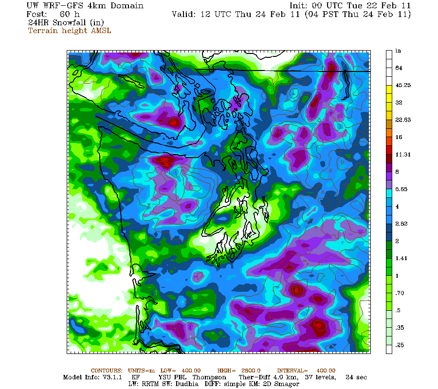
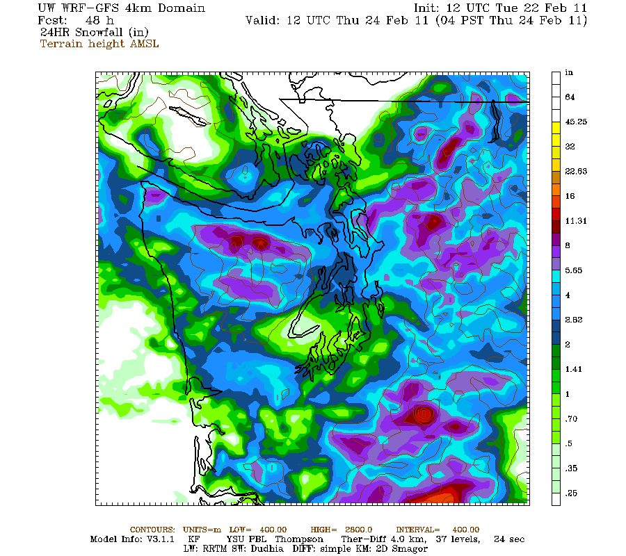
Let us consider how the UW WRF model did, since this is important guidance to both the National Weather Service, local TV folks, and yes, even me. Let me show you the 24h predicted snowfall for the period ending 4 AM this morning for several model runs starting days ago. Let see how consistent the 4-km resolution model guidance was and how it changed in time. You be the judge!
Here is the forecast initialized (started) at 4 AM on Monday. Note the lack of snow over Seattle and the Kitsap (due to rainshadowing off the Olympics). Heavier snow north of Everett and over the N. sides of the Olympics. Moderate snow over the eastside communities and heavy snow over the mountains. NOT BAD!.

The forecast made 12-h later. Similar situation
In the forecast begun 4 AM on Tuesday, the Bellingham snow threat has declined. The Skagit snow band was there, the Kitsap-Seattle dry band is there but weakened. But too much snow was evident over North Seattle.
Twelve hours later a distinct snow band was positioned over Seattle. Clearly, not right.

And here is the forecast from 4 AM Wednesday morning. The Seattle snow band had weakened and heavier precipitation had moved north. Better, but not perfect, of course.
 Now there are a few things you should take away from this.
 First, the model (and the others the NWS and I were looking at) was serious about snow; although the snow distributions changed from run to run, they all indicated a serious threat. Second, they all agreed the mountains would be hit hard...and they were. Most of them showed a lessening of precipitation over the Kitsap and southern Seattle, and substantial snow over the eastern suburbs. Most indicated enhanced snow in some kind of east-west band, but the position varied. This was a crucial point....it was clear that the greatest threat was in a zone of convergence between northeasterly coming from the Fraser River Valley (and surrounding low terrain) and southerly flow moving up the Sound. But there was NOT agreement exactly where this would be. There was uncertainty for this feature.
It also turned out there was uncertainty about where the low pressure center controlling a lot of this action would be positioned.
To get this prediction right the forecast had to simulate all the following correctly: the downslope off the Olympics , the flow through the Fraser Gap , the position and intensity of the low , and upper level trough approaching the region, among other features. All interacting in a very non-linear way. And it was worse than that. Most of the showers were from convection--isolated snow shower that are very much hit and miss. It was clear there would be a lot of banding and variability in the snowfall. Folks, getting all this right is beyond our technology and science.
So was this forecast a failure? I don't think so. Even though we did not have confidence where that intense snow band would set up, we could tell you it could set up somewhere resulting in very heavy amounts. We could tell you the mountains would get large amounts and that serious snow would hit the eastside. We could tell you about the rainshadowing over Kitsap and Seattle as being a probable element. And the snow on the north side of the Olympics. We gave a modest snow range over Seattle (roughly 1-6 inches depending on whose forecast you looked at) to cover the uncertainty.
Will we eventually do better than this? You bet...and we are working on a technology at the UW (called Ensemble Kalman Filter data assimilation) that might do so, but this is a few years off. And the new coastal radar will paint out the critical flow structures offshore that we can't see now.
This snow forecast is a vast improvement on what we could have done only a few years ago. And a critical issue it reveals is the necessity for my profession to learn how to effectively communicate the uncertainties in our forecast. To paraphrase an erstwhile Secretary of Defense: we need to tell you about the known unknowns.
And in a future blog I will discuss the shameless and occasionally irresponsible hyping of this event by a few media outlets, including their breathless description of sudden icing that supposedly would befall yesterday's commute...just like Nov. 22nd! Complete nonsense.


