The Storm

| comments

Its here.... A beautiful looking storm in the infrared and water vapor satellite imagery (first and second images below). The dark color in the water vapor satellite imagery indicates dry air descending into the low, a sign of strength.


Here is a the short-term forecast for 11 PM tonight...an impressive 966 mb low! There are a lot of isobars and very large pressure variations that produce strong winds over the Pacific Ocean.

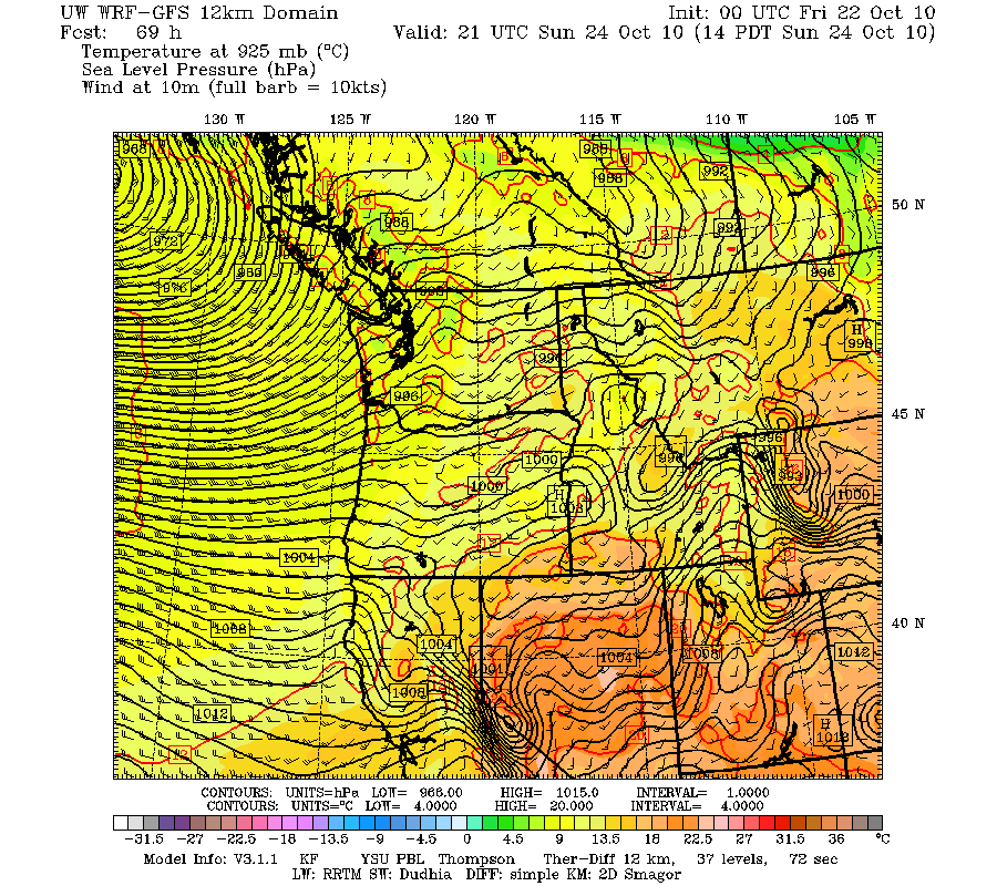
As forecast the winds have really accelerated offshore and along the coast, with sustained 30-40 mph, with gusts of 50-60 mph. Here are the maximum gusts at Destruction Island...right off the WA coast...gust to 54 kts-- 62 mph. Lots of wind gusts above 50 mph over the ocean. The waves are increasing rapidly...now approaching 20 ft seas offshore--and they will rise further.


Right now the winds are climbing over NW Washington (Strait of Georgia and eastern Strait)--here is the sustained wind forecasts for 1 AM (30-35 mph with higher gusts)


The Smith Is reporting station died, but here is from buoy 48088 at the eastern entrance to the Strait of Juan de Fuca. Peak gusts are at 35 kts and rising.


But this is NOT going to be a major wind event in Seattle...even though some TV stations (unnamed ) are talking about it.

And of course it is WET outside,with steady rain over the region...here is the latest radar--green is moderate rain, yellow is heavy. A very nice rainshadow NE of the Olympics.

The heavy rain should be done by sunrise, with showers tomorrow.

Computer models are having a hard time deciding where the low is going--we will see.

Meteorological Earmarks and the U.S. Senate Race in Washington

| comments


There has been a lot of talk in the U.S. Senate race in Washington State about earmarks, and I thought I might give my perspective based on some actual experience with them.
Patty Murray (Democrat)

If you had asked me a few years, I would have been against them, but my mind has changed, based partly on my experience with the coastal radar. I now believe that earmarks are a useful tool, if used sparingly and with judgment.

Dino Rossi (Republican)

Consider the coastal radar that will be installed next September on the central Washington coast. Without earmarks this extraordinarily important device, one that will save lives and greatly enhance our lives, would not have happened.

A classic argument against earmarks is that all appropriations should go through the normal process, with budget requests from agencies vetted by congressional committees. Sound good. But for over a decade many of us tried to go this route in pushing for the coastal radar. The case was compelling but some folks in the National Weather Service opposed it and letters from Congressmen and Senators fell on deaf ears.

Nothing happened until the big storm in December 2007, after which Senator Maria Cantwell took a personal interest in the project after listening to her constituents in coastal Washington. Senator Maria Cantwell

Subsequently, with the aid of Senator Murray, Senator Cantwell was able to secure an EARMARK for the first two million dollars for the radar acquisition. And the rest is history. Next September we will be able to see, for the first time, the structure of approaching weather systems from off the Pacific. The folks in Gray's Harbor County and surrounding areas will be able to plan their lives with the guidance of the radar. Fishers and marine interests will have the protection of the radar while they do their work. And this would not have have occurred without the intervention of our U.S. Senators.

My conclusion. Washington D.C. bureaucracies sometimes don't have a good understanding what is happening and needed out in the field, in communities hundreds or thousands of miles away. Our Senators and Congressmen/women have an intimate acquaintance with their area and know where the acute needs that slipped through the cracks. Therefore, we need earmarks.

Yes, I know there have been some abuses and some earmarks have been problematic. But my reading through the earmark lists suggests that the majority of them are well-intentioned attempts to fix problems or to deal with issues that the government bureaucracy missed.

It seems entirely appropriate that a few percent of the U.S. budget should go to earmarks. Perhaps there are reforms that could make this fairer, such as insuring that all states get an equal shot based on their populations, irrespective of whether their congressional folks are well positioned on critical committees or in leadership positions. But a flat rejection of earmarks does not seem reasonable and from my perspective earmarks were absolutely critical in securing a critically needed piece of meteorological hardware for our state.

Forecast Update: The Sunday storm looks similar to what we expect last night. Strong winds over the ocean and right along the coast. Not much over Puget Sound during the day on Sunday, but it will blow to the north of the Strait of Georgia and the eastern Strait of Juan de Fuca.

UW Dawg Dash:

At 9:30 AM on Sunday the UW Dawg Dash will take place (fun run to support scholarships and other good works) and I have been asked to be the official starter (http://www.promotionevents.com/dawgdash/) I believe the idea is that a meteorologist might placate the rain gods with some sort of professional incantation. At this point I have been unsuccessful--the latest model runs show showers that morning around that time. Perhaps some incense will help.


Major Coastal Storm and Big Waves

| comments


It is become increasingly clear that our offshore waters will be hit by a very powerful low pressure center (what we call and extratropical cyclone in the business). The result will be hurricane-force gusts over the eastern Pacific and 30-40 ft waves striking our coastline. The interior should be generally spared with one exception: Northwest Washington and the Strait of Georgia, which will get 20-45 kt winds.

In reality there will be three major weather events:

The first is the weak system moving through right now....a bit of rain and windy offshore, but nothing major.

The second is a stronger, somewhat wetter system on Saturday morning.

But the real McCoy is on Sunday morning--a deep low offshore, with a very wet front moving through Sunday morning.

Lets cut to the chase. Here is surface charts for Sunday at 2 PM:


This is a 961 mb low..quite deep. However, the last few runs have taken it farther offshore--which makes it less of a threat for western Washington and Oregon. Here is a closer in view at the same time. Lots of isobars (lines of constant pressure), which results in strong winds offshore.


Here are the model surface (10 meter above the surface) winds at the same time. Offshore there are sustained winds of 45 knots and the gusts would be much stronger. Actually, the strongest winds on the coast will be late on Saturday, when the associated occluded front moves in (see figure). Sustained winds on the coast could hit 45 knots with higher gusts. Great weather for storm watching.!

These strong offshore winds will raise the sea and wave reaching 30-40 ft will move towards the coast. Here is the output from the NOAA Wavewatch III model, which predicts wave heights using the forcing from the atmopsheric models.

If this storm was a few hundred miles east of its predicted position we would be talking about a major damaging even and the weather channel would be flying in one of their storm folks....but fortunately that won't happen (if the models are right). I should note a rule of thumb of local meteorologists: to get strong winds over Puget Sound and the southern interior the low pressure center must cross the coast south of central Vancouver Island (my book has more on this).

Want to see the storms lined up on the satellite imagery? The first frontal band is on us. The comma-shaped system offshore is Saturday morning, and the huge, pregnant cloud mass farther offshore..THAT is the big one.

I don't believe anything yet...but

| comments


I don't want to get anyone excited
.

And because of Typhoon Megi there is a loss of predictability over the Pacific. So the chances are it won't happen.

But with all of that said...look at the latest forecast for Sunday morning at 8 AM!

An extraordinarily deep low center just off Vancouver Island. 964 mb! And each model run brings the storm closer!

And look at the winds offshore in the next plot. Sustained winds offshore of 55 knots and more and certainly hurricane-strength gusts!


It could all disappear in the next run. But if it is still there in tomorrow night's forecasts, I would get excited. At this point we are only talking about very strong winds over the Pacific and the coast and strong winds over the Strait of Georgia. Not Puget Sound and south.

Want Warmth? Take a Hike!

| comments

Last night was a classic fall example of the development of a lower atmosphere inversion (temperature increasing with height). Here are the temperatures above Seattle during the past six hours (from the Seattle profiler at Sand Point, heights are in meters, temperature in C). BIG INVERSION! Temperatures increase by rougly 10 C (19F) between the surface and 800 m (2600 ft). That is roughly the height of Tiger Mountain in Issaquah. We are talking 64F at the top of Tiger Mountain and the forties at the trail head!

As I have explained in the past, these inversion are associated with clear conditions during most of the night, allowing infrared radiational cooling to space from the surface. Eventually the surface cools enough so that fog forms and at low levels there is some fog around the region...but you could rapidly hike above it. And you wouldn't have to hike very high. Here is a cam shot at the Summit in Bellevue at roughly 1200 ft (thanks to Peter Benda) where you can see some fog at low levels.

The sun will burn off the fog today and the inversion will be lost as the surface heats and warms the air adjacent to it.

The weather forecasts for this weekend are rapidly shifting, but a downhill plunge is certain.

Major Change to Stormy Conditions Ahead

| comments

I generally like to wait until I am sure about things before advertising a major change and now I am. The models are all going for a major shift to stormy and wet weather this weekend.

But don't worry...we have a few more days of sun and warmth ahead!

Three days--with sunny afternoons, highs in the lower 60s, and dry...but with fog in the morning. Yes, it is fog season and you get the fog because of the clear skies (clear skies allow radiational cooling to space).

The source of our beautiful weather....a high amplitude ridge of high pressure over us (see the examples for tomorrow and Wednesday below). But then something is going to happen...and you can see a sign of it in the second upper air chart...a trough will be moving in later in the week and in force over the weekend.


In contrast, here is the upper level chart for 11 PM on Friday. No more ridge. A strong trough offshore and a very strong jet stream heading right towards us in the Pacific (note the winds are parallel to the lines and the greater the number of lines, the stronger the winds).


And here is the 24- precipitation ending 5 AM on Saturday. Wet!

On Saturday there will be showers and then another system on Sunday! And lots of winds over the eastern Pacific. More later...

Fog Season

| comments


You know when the fog season is for the western WA interior? Right now. But the foggiest periods differ at other locations in our region.

Check out this figure, which shows the number of days of heavy fog (1/4 mile or less visibility) by month for a variety of locations.For Seattle, October is the foggiest month and the same is true for Olympia. You will notice that Olympia has much more dense fog than Seattle.

On the coast the foggiest month is August.

East of the Cascades at Spokane and Yakima, December.

Some people are surprised by all this...wouldn't the foggiest period be in the middle of the winter..during the rains of November through February? And for many locations the LEAST foggy period is not in the middle of summer, but in spring.

But if you think about it, it all makes sense. Most of the fog we get around here, and particularly the dense type, is radiation fog...which is generally produced by relatively cloud-free conditions in the middle and upper troposphere. Such conditions are often associated with high pressure and little rain. Long nights help it along, as does a moist surface. On relatively clear nights the earth can radiate heat to space and temperatures can cool to saturation...which leads to fog.

Fall is really good...the nights are getting longer, there is some occasional showers that moisten the surface, but there are still plenty of cloud-free nights to allow good radiational cooling to space. West of the Cascades, October is a sweet spot for all this.

Sunday Morning Satellite Photo (10:45 AM)--You can see the fog over the lowlands

On the coast they get some of this fall magic, but they also get some of the low clouds that hang out along and offshore of the coast during the summer.

Eastern Washington tends to be relatively warm in the summer and early fall and late spring, with little fog. But during the winter, the "bowl" of eastern Washington fills up with cold air and fog.

During the next few days, we will have warm and dry weather, but watch out for fog in the morning, particularly in river valleys. And as it get colder REALLY watch out for fog, since fog is often associated with roadway icing. The biggest weather killer in the Northwest...it is not wind or flood or storms...it is ice on the roadways....but more about that some other time.

The Meteorology of the Chilean Mine Rescue

| comments


Now that all of the miners are safe, it is interesting to think about some of the meteorological aspects of the disaster--and of the misinformation provided by the media.

Some of the media suggested that the miners could get the bends from "rapid decompression", but this is nonsense!

The level of the mine entrance, where the drilling is taking place, is at roughly 2400 ft above sea level, and the miners were trapped at a level a few hundred ft above sea level. Clearly, the pressure was higher where the miners were--roughly 8 % higher. And it took them about 15 minutes to make the change as they were lifted out. This is nothing to worry about! Virtually all of you experience this change many times each year. An example: drive to Snoqualmie Pass (elevation roughly 3200 ft) from the west. The last fifteen minutes you gain roughly the same elevation in the same amount of time! Or when you take off in a plane, take a long lift ride while skiing, take that gondola ascent on vacation, etc., you experience the same or worse!

Then there was the "steam" coming out of the hole (click on picture to see video):


Why the cloud coming out of the hole? The temperature down in the mine was very warm (90-105 from various reports) and there were sources of moisture down there. The air had sufficient water content that when it hit the cool nighttime air, it was cooled to saturation--thus the fog. It looked to me that temperatures were fairly cold during the evening rescues---40s F perhaps from the jackets people were wearing. A small contribution could also have come from the expansion cooling of the air as it rose.

The region surrounding the mine is very, very dry--in fact one of the driest places on earth...the Atacama Desert (see map). Some locations have never observed rain, and in others they receive perhaps a few hundredths of an inch per year. Why so dry? Sinking air from a subtropical high, the high Andes preventing moisture form moving from the east,

Mars or the Atacama?
and the coastal mountains preventing moisture movement from the west. Plus an inversion aloft that stops the air from moving over the coastal mountains.

And talking of media issues...which country is wrong in this map?

The mine site from space


LOCAL WEATHER ALERT: Looks like dry conditions for the next 4-5 days with considerable sunshine!

Contrails!

| comments

Here is a marvelous picture from the NASA MODIS satellite showing conditions this afternoon over the Northwest (you can see the Columbia River directly below). There are some high cirrus and cirrostratus, but what caught my eye was the extraordinary show of jet contrails (click on the image for a better view).

Contrails occur because composition in jet engines produces water vapor and small particles. The water vapor is injected into the very cold upper atmosphere, where the vapor rapidly condenses into small water droplets or ice crystals. Particles produced by combustion can help this condensation process.

Contrails are promoted by an atmosphere close to saturation--so that is why contrails are particularly evident on days with cirrus or cirrostratus around (indicating upward motion and air at or close to saturation). Below is this afternoon radiosonde sounding (balloon-launched weather instruments) at Salem, Oregon, temperature is red and dewpoint is dashed blue. Above 500 mb (roughly 18,000 ft), the temperature and dewpoint are relatively close, indicating an atmosphere close to saturation.


Several times of year I get emails from people claiming that contrails are really chemtrails, which have been injected into the atmosphere by some dark government conspiracy. Obviously complete nonsense, and my attempts to point out the weaknesses of chemtrail theories rarely convince them. It is similar to those folks who feel that Elvis is still alive--you can't convince them otherwise.

Update Sunday Morning

| comments


Here is the latest 24-h rainfall map from Seattle Rainwatch. Heavy rains continued last night and the focus was in a band stretching from the SW side of the Olympics through south Seattle into the foothills. A number of locations have received 2-3 inches with 3-5 inches on the western slopes of the Cascades. During the last 24-h (ending 8 am) Shelton has had 3.8 inches, Quinault 5.35 and the NWS has a flood warning out for the Skokomish River.

But things are about to change....the latest radar shows the wet front band is about to move through central Puget Sound

and the latest visible satellite image shows not only the frontal band...but clear skies behind (see images). Unfortunately, improvement will be slow for central Puget Sound where a convergence zone will set up today. Here is the forecast precipitation ending 11 AM:


and the forecast cloud cover at 2 PM:


So if you want bright sun today and you are in western WA..you can have it...just get out of the convergence zone. That is what I am going to do!

Heavy Rains

| comments

Driving home from downtown Seattle, I experienced very heavy rains and street flooding.

A good time to check out Seattle Rainwatch (http://www.atmos.washington.edu/SPU/), which has been funded by Seattle Public Utilities. Here is the latest 24-h rainfall:Some areas in the lowlands have gotten 2-2.5 inches of rain, with nearly the entire lowlands receive more than .5 inches. Except....almost no rain in some areas northeast of the Olympics in the rainshadow. It is very typical for the Hood Canal and Kitsap area to get hit by heavy rain during southerly and southeasterly flow as the air is forced upwards by the Olympics. Remember, you can NOT trust the radar precipitation amounts over the mountains, where substantial blockage occurs.

Looking at the current radar image, you can see the heavy rain from Seattle southwards and the rainshadowing to the north.
Temperatures have warmed tonight in many locations as a warm front has pushed northward. We are in fact in the middle of a plume of warm, moist air, known as an atmospheric river (see graphic of total warm vapor).

Later tonight a cold front will approach (yes, with more rain) and will move through tomorrow morning. Want dry conditions and sun tomorrow? No problem...head north and west for earlier breakout. But a warning...a convergence zone will form in the north Sound tomorrow afternoon, so avoid the zone between Everett and north Seattle if you don't like clouds!

Picture of the Day

| comments

Here is a marvelous satellite picture, taken 2:30 PM this afternoon. You can see the line-up for this weekend in this visible satellite image (click for a larger version). The first cyclone (low pressure center) is off the coast--you can see the spiraling clouds (the low center is in the middle of the spiral). A front radiates from the low and the clouds is rapidly approaching the coast.

Further offshore you see a vigorous, younger system--note the spiral is not complete yet. The thin line of enhanced cloud extended roughly east-west south of the young system is a rope cloud, a line of cumulus and cumulonimbus that mark the position of the cold front. And north of the young system is a large field of open cellular convection, convective clouds associated with cold air moving over warmer water.

And here is another pretty graphic...the latest 24h precipitation ending 5 PM on Saturday. Heavy rain on the southwest side of the Olympics and the Willapa Hills of SW Washington (and Vancouver Island and the north Cascades) and a beautiful rain shadow to the northeast of those mountains. Those folks in Sequim may be golfing tomorrow while the rest of us get wet.

Bottom line: satellite imagery and model output are sometimes so attractive you could hang it up on your wall!

Heavy Weather Ahead

| comments

The weather has turned very nice lately (see plot of temperatures versus normal max and mins), with cool, crispy mornings and sunny, warm afternoons. Some trees have started to turn colors and leaves are already wafting to earth. Just perfect. But more active weather is on the way...but not before our pleasant period continues a while longer.

Thursday will be a repeat of today, but later on Friday a strong system will approach and another will head our way on Sunday. Here is the predicted surface chart for 11 PM on Friday--a strong low west of N. Vancouver Island and LOTS of pressure gradient...and associated strong winds over the offshore waters. As the low moves inland you can expect strong winds to develop in the Strait of Georgia as well.


Here is the forecast sustained wind field at 8 PM (the gusts will be far higher). Lots of sustained 35 knot winds, with gusts probably reaching 40-45 kts.

Associated with the low and strong winds will be a strong current of moisture and fairly heavy rains will fall over the Olympics and mountains of Vancouver Island Friday night (2-5 inches!) and moving into the Cascades on Saturday ...see graphic below of 24-h precipitation ending 5 PM on Saturday.

Don't water your grass. Hiking in the Cascades on Saturday--particularly in the morning-- will require Gortex.

And another low pressure system...with landfall somewhat farther north...will occur on Sunday, bringing more rain to the area. But don't worry, a stretch of sunny, warm weather beckons next week.

TV Weathercasters

| comments


A question that I get asked all the time (including yesterday, which stimulated this blog) is what do I think of TV weathercasters? Who is the best one? And similar questions.

The truth is that the quality of these folks vary widely and many are not even meteorologists. And their forecasts tend to follow the NWS closely.

One thing is remarkable--the only scientific discipline to have a representative on virtually every news broadcast is MY field---meteorology. Quite an opportunity! TV weathercasters are often consider the station scientific experts...which has its ups and downs as I will note below.

I like to use the term TV weathercaster, even though many, if not most, call themselves meteorologists. The truth is that many, if not the majority, are NOT meteorologists...if by that you mean someone who has an actual degree in the subject. They looks good and talk well on TV, which is a real skill, of course. But it drives me crazy seeing people without a real background in the topic call themselves a meteorologist. Should TV medical reporters be called doctors? Or TV financial reporters be called economists?

Those with the strongest backgrounds tend to do the weather during the week, with the weaker folks (with a few exceptions, like Shannon O'Donnell of KOMO) doing the weekends. Some of the weekend types are a real problem, point to the wrong features on satellite pictures or misinterpreting the radar imagery (no names!).

I teach atmospheric sciences 101 and on several occasions I had asked my students (for extra credit) to write down the forecasts of the TV weathercasters from all of the local stations. Then we did a statistical analysis comparing the TV folks to the National Weather Service (NWS). The result: there was no statistically significant difference among the forecasts. Bottom line: the TV weathercasters don't stray far from the NWS forecasts, and they probably shouldn't. The NWS forecasters have degrees, many years of experience, and are receiving updated training. I occasionally have my issues with NWS forecasts (like a slow update cycle, not wanting to change forecasts too rapidly, and lack of emphasis on strong-range forecasting), but they are experienced pros. And they are willing to go on rotating shift to give us 24-h forecasts, which we all should be thankful.

A maddening aspect of the TV weather business is the weather hype that news directors seem to think as mandatory. Here in Seattle, snow is hyper-hyped. And one station even has a professional weather hyper, Jim Foreman of KING TV, who I love to tease. "Pinpoint forecasts", "County by County Forecasts", "Severe Weather Center", Doppler this and that, you have heard it all! Sometime I would like to visit a "Severe Weather Center"--but perhaps it would be too dangerous. And some of the graphics on air are impressive, but entirely confusing--like the "fly-through" 3D clouds and precipitation animations that are so popular on some stations.

The American Meteorological Society has a program to certify TV weathercasters--the AMS Seal of Approval--which has recently been updated to REQUIRE that the certified have real degrees. Other organizations, like the National Weather Association, also have certifications that require less background.

Here in Seattle we are very fortunate to have a very good group of TV weather folks. Many have real degrees (from the UW!) including Jeff Renner, M.J. McDermott, Shannon O'Donnell, and Rich Marriott. Steve Pool was not only tutored at the UW (by me), but works closely with Scott Sistek, who got his degree at the UW. Steve has been around long enough to know the local ropes. Scott S. also has a very good weather blog. Rebecca Stevenson took the weather course at Mississippi State and sat through the UW senior weather forecasting class. In short, the Seattle market has very good people, except for some of the unnamed and less experienced weekend folks. Portland also has some excellent weathercasters, such as Mark Nelsen, who is also a degreed meteorologist.


One of the more controversial aspects of TV weathercasting these days is that a small number of them have been energetic global warming "skeptics." An survey of more than 500 TV weathercasters found that one in four of them say there is no global warming, with 27% agreeing with the statement "global warming is a scam". Most of what these people are saying makes no sense, and quite frankly TV weathercasters generally have little background in climate science. My advice--go elsewhere for guidance on this issue.
 
Support : Creating Website | Johny Template | Mas Template
Copyright © 2011. The Weather - All Rights Reserved
Template Created by Creating Website Published by Mas Template
Proudly powered by Blogger