
First, here is a wonderful MODIS satellite image that shows the smoke yesterday very clearly:

And here is the image this morning from the GOES satellite (visible, high-res)

This smoke is above the surface in the middle troposphere and is coming from the southwest. Examining the flow aloft it really appears unlikely to be coming from any of the western U.S. fires...and I will prove that now.
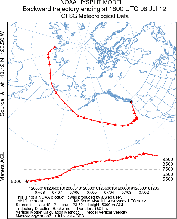
The NOAA Air Resources Lab has a wonderful facility online-their HYSPLIT model in which you can computer air trajectories in time. Well, I tried this for a point over Seattle at 5000 meters...and traced back the air parcel trajectory back in time over the past 180 hr.
Here is what I got using HYSPLIT. The air over us can be traced back to Asia at low levels. (Think about that when that next coal-ship leaves a Northwest port to Asia--we ship the coal one way and pollution comes right back!)

In fact, some other modeling systems, such as one using output from ECMWF global model were suggesting the same thing--there are large areas of smoke over Asia that are moving our way (see figure below...aerosol optical depth is a measure of the effects of the smoke on visible light)


Take a look at a MODIS satellite image showing smoke, with the red dots showing fire locations--pretty murky.

I believe many of you...particularly those near the coast and northwest Washington will be above to see the smoke, particularly at sunset, where the sun should look redder than normal. Here is a shot from the cam on top of my building at the UW (the smoke layer is evident). In fact, I went to Richmond Beach Park on the Sound tonight...the smoke layer was much more dramatic than this photo suggests, and the sun was quite orange-red before it set.

Here is a picture of the smoke near from near the top of Mt. Baker by Lowell Skoog. Amazing image.


Sunday night update: here are the trajectories for air ending over Port Angeles, WA at 5000 meter at 11 AM Sunday...still coming from Asia.
SUBMIT YOUR WEATHER PHOTO FOR THE 2013 WASHINGTON WEATHER CALENDAR
The UW AMS Student Chapter is partnering with KING 5 News to create the 2013 Washington Weather Calendar. A photo contest is OPEN and I would like to encourage everyone to submit your best weather or nature photos of Washington State to the photo contest. In particular, we are looking for "images of weather, wildlife and natural signs of seasonal change on land, in the air, or underwater." There is a *$200 cash prize for the winning cover photo* and winning monthly photo entries
will receive a free calendar. The deadline to submit photos is July 31st.
As the charitable partner of the project, the UW AMS Student Chapter will
receive a portion of the proceeds from the calendar sales.

*To submit photos and for more information, please visit this website*:
http://www.king5.com/community/Submit-a-photo-for-the-KING-5-Weather-Calendar-160272225.html


