
To "warm up" this blog, lets start with the temperatures at Sea-Tac the last two weeks as well as the normal highs and lows:
 Only two days of the last 14 have reached the normal highs, and none have exceeded normal. Today we had a ridge (see upper level map for this afternoon) over us and the clouds finally dissipated during mid-afternoon
 ....very nice for a while. Here is an educational video of today's clouds. First we start with the low murk coming out of the south, then mid-afternoon it breaks and you can see the large wind shear in the vertical, with westerly winds aloft. Later in the afternoon, high clouds start pushing in aloft and if you look carefully you will see a 22 degree ice cloud halo around the setting sun.
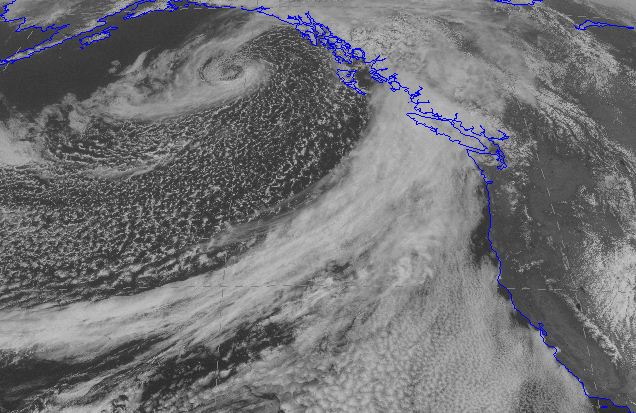
But it won't last. A moderately strong front is bearing down on us and tomorrow will dawn cloudy with rain by midday. Here is the visible satellite image for this afternoon. Very nice front stretching from Vancouver Is. to the the southwest. A large field of low clouds off of California (very typical in spring). You can tell they are low because they don't push past the coastal mountains. Behind the front you can see the speckled instability clouds (open cellular convection in the biz) associated with cold air and a nice little low is spinning around in the Gulf of Alaska.
Now the depressing part.
You see the deep trough over the Gulf of Alaska in the upper level weather map above? Such troughs are associated with low -evel cold air. That trough is going to move south and the settle over the eastern Pacific for a long time. I mean a LONG time. Here are the forecasts for Friday afternoon and Monday morning:

 Upper level troughing dominates the entire period! Let me put it diplomatically....this is NOT a warm pattern for us and it will produce highly anomalous cold and precipitation into central and northern CA.
Well, what do my friends in the National Weather Service have to say? Here is the 6 to 10 day temperature forecast probabilities. It is probable that whole West Coast will be colder than normal and northern CA and southern OR WAY colder than normal.

And precipitation for the same period? Do you have to ask?


