
Sitting in Seattle right now, its 30F and big aggregate snow flakes are slowly drifting down outside of my window. That plus a nice cup of tea and a successful forecast--life doesn't get much better than that.
But it won't last unfortunately.
Right now a warm frontal zone is moving in overhead...that is producing the precipitation, but it is also producing warming aloft over the region. Here is the latest infrared satellite picture. You can see the main front offshore (band extending SW-NE) and the warm front is the stubby appendage extending NW-SE over us. It will only give us 3-6 hr of precipitation.

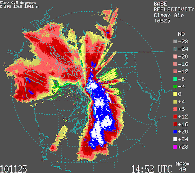
Here is the latest (6:42 AM) radar--in clear air mode, because the precipitation is light. You can see the precipitation (snow) and also an area just east of the Olympics is not getting anything. The reason--there is rainshadowing (really snowshadowing!) because the flow aloft is out of the northwest. So the folks on Kitsap with all the power outages are not getting much snow....there are balances to life evidently.
Temperatures are warming aloft. Here are the hourly temperatures soundings (temp plot in the vertical) here in Seattle from the profiler. These temperatures are really virtual temperatures (don't ask...just subtract about 1C for regular temperature, and yes they are in C). Height in meters. You are looking at plots starting at midnight (2508) to 6 AM (2514). The clear message is that temperatures are warming and we now have a layer near freezing in the lowest several hundred meters--this is a layer of precipitation melting. These are wet snowflakes.
 Here is a different view of the temperatures and winds above us from the profiler...called a time height cross section:
 You can see the warming southerly and southwesterly flow (look at the wind barbs) above us and warming is evident..yesterday above us the virtual temperature was -8C at 500 meters, now it is -1C (really -2C actual temperature). This snow is not going to last long..a few hours at most. Clearly, the warming is happening a few hours faster than expected by the models last night. So I would not give the snow much more time now...hour perhaps over Puget Sound. But it could hold in longer over NW Washington, where cooler flow exiting the gaps will maintain the snow for a few hours more.
This is good for DOTs and holiday travel around the west....temperatures are now climbing above freezing and wet snow will end in a few hours. Good for holiday travel. And the end to an early major cold snaps around here--one that will go into the record books like 1955 and 1985.


