Sometimes I look at the computer forecasts and just have to say WOW!. Take a gander at the sea level pressure forecast over the NE Pacific on Thursday--an amazingly intense low center dropping below 950 mb. And the SUSTAINED winds SW of the low center are roughly 55 kts (other plot)--certainly with hurricane force gusts. Look how close the isobars are (and how strong the corresponding winds are) for a vast area of the Pacific. Just plain impressive. They don't call these storms hurricanes because they aren't tropical, but they pack a bigger punch. Huge size and big winds. And very, very dangerous to be near them on the water.
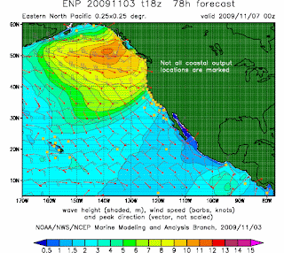
And can you imagine the waves? Well, you won't have to imagine anything..they will hit our coast. Wave development requires strong winds, large ocean area to work on (fetch), and time. This storm has it all! The NWS runs the Wavewatch3 wave model, which is driven by the output from the atmospheric model forecasts. I have included some sample forecasts. Huge waves develop--reaching roughly 40 feet--and these waves propagate as swell towards our coastline. It will get pretty amazing along the Washington coast this weekend...I am sure the NWS will be providing marine warnings of 20-30 foot waves.
You won't have to watch Deadliest Catch on TV or watch a DVD of the Perfect Storm to see big storm waves...Westport or Ocean Shores will do just fine.


