Cold Wave Over the Lowlands

| comments


Other than a good snowfall in the mountains and I90 eastbound being temporarily closed due to spun out cars--things are quieting down right now--for a while.

It is now become clear--with consistency among model runs and between models--that we will be entering a cold period starting late this weekend, with Monday and Tuesday bringing the coldest air since early December 2009. And it is sure that there will be strong northeasterly flow flowing through the Fraser River Valley, across Bellingham, and out across the San Juans and that this flow will strike the N. Olympics peninsula with a vengeance.

What is less sure is the snow over the lowlands, from Seattle southwards. And I don't want to overhype things...the cold will be brief, the snow light if it comes at all, and normality will return well before people have to travel for Thanksgiving (I have just lost the interest of several TV stations around here!)

The big Kahuna goes first..the cold wave. Arctic air will first start leaking into the area on Friday through the Fraser and other gaps and then push southward over the region late Sunday. Here are a few images of the model output for Friday afternoon and Saturday am showing near surface winds, and the surging air from the interior of BC. They are going to be strong! Heading over the northern San Juans, into Vancouver Is and then southward towards the Strait.

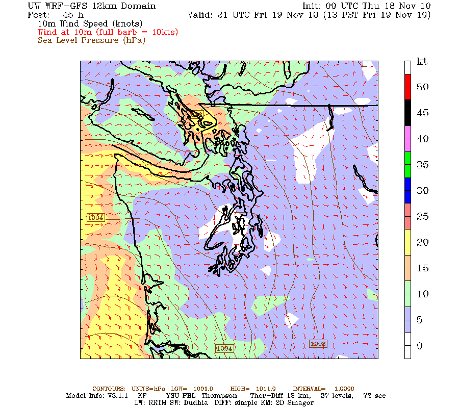
Initially (Friday and Saturday), the cold air will be mainly over the gap-wind areas.

Here are pressures, winds, and temperatures at low levels at 7 PM Friday. Blue colors are roughly cold enough for snow. You will also notice a substantial low pressure center over the SW part of the state.


Saturday afternoon...still too warm for snow over most of the western lowlands.


But on Sunday the low goes south and the cold air follows. We are then at the temperature transition point and there will be some light precipitation left. Yes, a chance of snow showers in the lowlands on Sunday, but nothing major and lots of uncertainty.


And Monday afternoon, cool air has made it over us. But there will be little precipitation and thus little snow.


Monday and Tuesday might see highs limited to the 30s! and Monday and Tuesday morning temps could easily fall into the 20s...and even the teens in outlying cold locations. Good time to remove hoses from faucets so they won't freeze up and other protective actions. Protect vulnerable plants. But I don't expect really damaging temps--and keep in mind this is early so the soils are relatively warm.

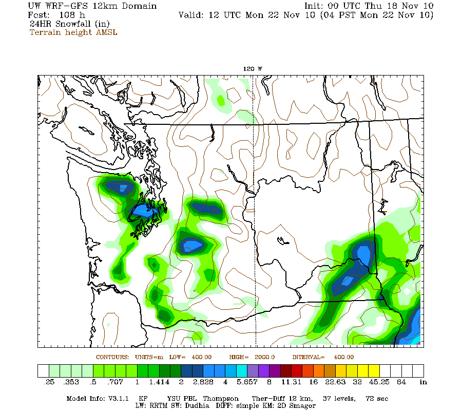
What about lowland snow? On Saturday it will be limited to NW WA and the Fraser outflow region, so Bellingham, San Juans, Vancouver Island, and the north Olympic peninsula. You will undoubtedly find some TV station remote crews there. Here are the 24-h forecast amounts ending 4 PM Saturday. Also some snow in the mountains.


Sunday we have a battle going on...the cold air is moving in, but the moisture is moving out. And you need both for snow. Here is what the model thinks for the 24-h ending 4 AM on Monday. Seattle and snow lowland locations do get some...but folks, I would not bet on any of this. The next series of runs will undoubtedly have the snow in a different pattern. And after that we go dry and cold. Sorry.


So be prepared for some light snow on Sunday, as I am sure the Seattle DOT and WSDOT will be. The model runs on Saturday will be a far more dependable guide than what we have four days out. If you want to read more about what it takes to get snow around here and read about some of the great NW snowstorms, check out Chapter 4 of my book.

Windstorm Factoids

| comments

Wednesday morning update: looks certain we will get major cold in western WA Monday-Wed next week and a real chance for light snow in the lowlands from Seattle south on Monday. And snow over the weekend on the N. Olympic Peninsula...more tonight!

We had quite a blow last night, although for most it wasn't more than the kind of windstorms we get a few times a winter. However, as I will mention to below, there were some subtleties here....for example, as I will explain there really was two distinct wind events going on. Also, later in the season there would have been far less damage and power outages. This was the first storm of the season and there was plenty of decayed and vulnerable branches ready to to...and the leaves still on many trees makes it worse! And there were plenty of careful construction folks who did not prepare for strong winds or forgot to finish their work (like a portion of the new departmental bicycle shelter that blew away!)

200,000 lost power last night and there were some impressive wind reports:

North Bend, WA--sustained 36 gusts to 60 mph
Port Townsend-50 mph
Tumwater-40-45 mph
Sea Tac-49 mph
Eastern Strait (buoy 46088): 56 mph
Wenatchee 63 mph
Mission Ridge 105 mph
Stevens Pass 117 mph
Whidbey Is NAS 61 mph

As I describe in my book, one of the most entertaining aspects of this and other windstorms is the firework show that occurs when the winds start blowing. Lightning? Nope. The multicolor displays are caused by transformer fuses or cutouts (see picture) When a circuit get grounded by a branch or some other object, these fuses can blow--cutting off the circuit with a bright flash. Then the associated neighborhood goes dark.
Want to watch a video of the fun? Check this out:

http://www.youtube.com/watch?v=LXLpL1Ai0bY

Now the winds of yesterday were really concentrated in several areas:

1. A surge of strong westerly winds in the Strait as the low center moved by and the winds aloft aligned with the Strait. I call this a westerly Strait surge and they can get much stronger than Monday's event. One took out Ivar's Mukilteo Landing Restaurant in 2003.

2. Strong southerly and southwesterly winds in the southern to central Sound. This had associated with two things...the strong low passing to the north and strong lee troughing off the Olympics (more on this in another blog)

3. Very strong NW wind aloft associated with the passing low and its associated upper trough. This provided the strong winds at mountain stations.

4. Strong downslope winds hitting the lower portions of the eastern slopes.

Our high resolution models did get most of this right. To prove to doubters--here is the wind forecast (sustained winds) for 10 PM on Monday made more than 36 hr before (multiply by 1.5 to get gusts).


What about snow?

First, there will be heavy snow in the mountains. Feet of it. Be prepared if you are driving over it...you may need chains.

Over the lowlands, the big threat over the weekend will be NW Washington and the northern parts of the Olympic Peninsula. The latest runs will bring cool, air from the BC interior through the Fraser and other gaps in the Cascades...starting later on Friday. Vancouver, Blaine, the San Juans,Vancouver Is., and northern Olympics could get some snow very late Friday into the weekend. Serves those smug folks in the Sequim rainshadow right!...this time they will be on the windward side as strong NE wind head right towards them.

Is it Going to Snow Over the Lowlands?

| comments


Several of you have asked the potential for cold and snow this weekend, and this morning the National Weather Service put out a special statement regarding the possibility of a change to more winter-like conditions. And today, I got several calls from the media about it. And yes, the local TV stations are already talking about it online and on air. It is never good to get excited about snow too early--there are a few ways to get snow in the lowlands and so many ways for it to go wrong.

Anyway, we are now close enough to the weekend, and the models are in good enough agreement, and I am comfortable talking about what I see happening.

Bottom line: forget lowland snow this weekend but lots of snow in the mountains this week. Strong NE winds will blow through the Fraser Valley into Bellingham and NW Washington and colder air will spread over the region on Sunday and Monday. Clear evidence of the classic La Nina pattern. Maybe snow on late Monday or Tuesday, but too early to be sure. At this point, the Mayor can keep his snowplows in the garage and Jim Forman of KING TV can get his famous parka dry cleaned this weekend. And there will be loads of active and interesting weather during the next week!

But lets start with tonight. A low pressure center is now passing north and northeast of us, bring a strong N-S pressure difference and gusty winds (see image). During the past hours winds have gusted to 30-40 mph over the area, with some minor damage. Nothing special in November. Perhaps more special are the stronger (30-65 mph gusts) winds predicted for tonight and tomorrow morning over the eastern slopes of the Cascades. My lights are flickering right now and my Uninteruptable Power Supply (UPS) is going on and off!

But the weather fun is just beginning!!

During the next two days the upper level pattern is going to change radically--to one reminiscent of many La Nina winters--one with a very high amplitude ridge over the eastern Pacific and troughing and cold air in our area. Here is the situation on Wednesday morning aloft. Huge N-S ridge extending to the Aleutians and a high-amplitude trough to its east.
At the surface, there is a strong low center NW of the tip of Vancouver Island and REALLY cold air move southward into northern BC.

On Wednesday and Thursday trough and low slowly slip southward. And a strong,cool, moist flow hits the Cascades and Olympics...the result? Several FEET of new snow at pass level and above (see one 24-h period below ending 5 AM Thursday). Good for Thanksgiving skiing!

But then the weekend. The low slowly weakens and moves south. No cold air over us on Saturday. On Sunday at 4 AM the surface pressure pattern and low-level temperatures (shaded) and winds (the barbs) are shown below. The cold air is still mainly stuck in British Columbia--with one exception---air starts flowing through the Fraser River Valley into Bellingham and NW Washington, accompanied by strong NE winds (see figure)

The problem for snow lovers is that the precipitation over the weekend falls as rain over the lowlands since the air is too warm. And then when cold air moves in later on Sunday , things have dried out. Here is the predicted snow for the 24-h ending 4 AM on Monday. The only snow is over far NW Washington and southern BC. Remember this is sustained winds..really roughly 20 minute sustained winds..you must multiply by at least 1.5 to get gusts.


The situation changes on Monday and Tuesday, but that is too far out to be sure about anything. The cold air will be in place and showers could bring snow in a convergence zone or other feature. And the upper level pattern looks much more like the canonical snow pattern. So keep tuned. And consider that there is still some uncertainty for the forecasts over the weekend...we are still days out and a modest shift in positions of some features could have a significant impact.

By the way, there was a lot I didn't mention...like strong SE winds over NW Washington on Wednesday and Friday..and the strong coastal winds with the low on Friday. Or the strong westerly wind surge into the Strait of Juan de Fuca tonight. My colleagues at the National Weather Service will be worn down when this week of active weather is done!

A Weather Fact That Can Save Your Life

| comments

NOTE: I will be posting about snow and cold tonight...bottom line: no or very little snow in the lowlands. Media hype has begun, so beware!

On the chilly Thursday morning, as I got on my bicycle, I noticed some frost on the grass even though my thermometer read 36F. How could this be? It turns out that such a situation happens all the time and understanding this effect can keep you safe while driving and biking.


The evening before the skies had been quite clear (see satellite photo)


Clear skies allows the surface to cool off rapidly be emitting infrared radiation (the atmosphere does the same thing but is not as effective). The long nights of the fall season helps, as does light winds...and we had them all that night. The result? The surface cooled more than the atmosphere above, producing a surface-based inversion (an "inversion" of the normal situation of temperature cooling with height)--see the figure below.


On such clear nights a large difference in temperature can occur in the lowest few feet of the atmosphere, with ground sometimes 1-5 F cooler than the air at the official height of temperature measurements, which is at 2 meters or roughly 6 feet. I have walked around my house at night with a thermometer to demonstrate the effect (my neighbors must think I am a touch crazy) and found cases when my shoes are 5F cooler than my chest! So when a TV weathercaster gives you the surface temperatures they ARE NOT at the surface, but rather at 2 meters! Thus, the temperatures at the surface can be substantially cooler than the official or other reports.

So if you hear the weather report and the temperature is 35F and we are in one of those low-wind, clear situations, frost or ice IS possible at the surface and you better be careful. Many cars have thermometers that provide the outside temperature on your dashboard. These sensors are a few feet up and can be warmer than the surface for the same reason as noted above. So if your car thermometer says 33 or 34, there could be frost at the surface.

Now there are other complications of course....after a warm period, heat from below the surface can keep the surface above freezing on these nights--but I would not depend on this. And bridges have no heat coming up from the ground below and they are generally the first places to have frost or ice.

And for those of you thinking that a little ice or frost at the surface is nothing to worry about, consider this. Roadway icing undoubtedly kills and injures more NW citizens than ANY other weather phenomena....windstorms, floods, hail, tornadoes, you name it!

If weather is going to take you out it will probably be some roadway ice somewhere!

We are now entering the core of the roadway icing season...so be careful! WSDOT is quite knowledgeable about this threat and pretreats some roadways to prevent ice formation, but they can't be everywhere, so you have to protect yourself.
If you want to learn more about this demonic threat, check out my website on roadway icing: http://www.atmos.washington.edu/~cliff/Roadway3.html

Is Seattle Ready for Snow?

| comments

During the past few days there has been a great deal of media attention regarding Seattle's updated plans for dealing with lowland snow in the city. At a recent press conference, a comprehensive city response plan was discussed and the Mayor made it clear that the city had taken wide-ranging steps to be prepared.


This whole discussion is very timely considering the latest weather forecasts for later next week--the atmosphere is moving towards a La Nina-like pattern with ridging in the eastern Pacific and cold air plummeting southward. (Don't get too excited yet---most of the time cold and snow forecasts more than a week out don't materialize for reasons I can discuss in another blog). But I am sure Jim Forman of King-5 is waterproofing his famous ski parka.

Last month I was invited to talk to the Mayor's staff and some of the department heads (as well as Metro staff) about the potential for snow this winter. Let me tell you, these folks are serious about dealing with snow and preventing a repeat of the disaster of December 2008. And their newly released snowstorm plans are impressive in many ways and many of the mistakes of 2008 will not be repeated.

First, they will aggressively pre-treat roadways BEFORE the snow hits so it will not bond to the pavement. They will use salt on roadways after snow falls to encourage melting. They will plow the snow to the sides instead of into the center of streets (snow in the middle of the streets creates major barriers preventing turns, the snow melts and then refreezes as ice in the traffic lanes, and many other bad things). No more packing the snow down and sprinkling some sand on it. They are going to coordinate with METRO to get the buses off streets on which they will only get stuck. They are going to triage the roadways, as noted in their snow map below. They are making it clear that only main routes will get treated and plowed. This makes sense--with limited resources you have to use what you have to open the city rapidly to buses and commercial traffic. Then, with main roads clear and the main bus routes running you take on the side streets.


Clearly, Seattle must triage since they have only 30 snowplows, which is not nearly enough to clear a city this size--so SDOT has to work smart. (FYI--Denver has 68 plows but they get nearly 60 inches of snow a year, roughly 6 times more than we do, but we have more of an ice problem).

So we are in a much better place than two years ago and Mayor McGinn and City of Seattle staff are highly motivated and working hard to be prepared.

But let me provide some suggestions considering the meteorology of Seattle snow events.

Seattle snow generally falls on relatively warm ground that initially melts the snow into slush before it refreezes. That is why we frequently have an ice problem after snow events. You have to plow it off rapidly before it freezes, and if you can't do that you need to pretreat to stop it from bonding to the concrete so when it does freezes you can scrape it off. And you need to get salt on top of any frozen roadways to encourage melting.


So rapid response is key. And so is getting the vulnerable buses off the roads...particularly the trolley buses and the double buses, both of which are disasters in snow.

Now the city has 30 plows. Lets say that 25 are available at any one time (which would be very good I would think). And lets assume that they plow at 20 mph. So they could cover at best roughly 500 miles of roadway an hour. How many miles of roadway lanes are included in the routes outlined in the map...my rough estimate is 1200 lane miles. So it would take 2.5 hours to cover the city--and that is optimistic. If the snowfall is relatively light (.5-1 inch an hour) this might be ok, but if the snow is heavy (several inches per hour) there is going to be trouble. My suggestion: have a smaller core set of major streets that get priority in heavy snow. Get those clear, keep them clear, and steer the buses to those streets.

If snow is forecast and some people absolutely need their cars, they might be encouraged to move them to major parking lots near major streets and bus routes...like those at Magnuson Park, Northgate Mall, the UW, etc.

Now a major worry is Metro bus service. As noted above, the trolley buses need to be pulled at the first sign of snow (they skid, move off the overhead lines, and are like dead whales) as should the articulated (double) buses that jackknife on snowy hills. Let SDOT clear the roads to bare pavement and then those buses can be used. Core, protected snow routes, need to be established (I think they are going to do this). And service needs to be increased above normal frequency on those routes. People might have to walk a bit, but they will be able to get home.

Now a sore point for me is Metro's bustracker software. This should be a critical element for snow situations, allowing people to see where the buses are (and aren't). In December 2008 the Metro bus tracking site completely failed under the load of potential bus riders. They have made some moderate upgrades (roughly three times the capacity), but those will probably not be enough, particularly now that many people have internet on mobile devices. Getting a properly size server would not be that expensive and should have been more of a priority.

The other problem is the ancient bus tracker technology Metro is using. Instead of using GPS, which is modern and now inexpensive, they are using an old fashioned radio system that is not only undependable, but which is guaranteed to give poor results when the buses go off their normal routes. Metro knew they had this deficiency two years ago and haven't dealt with it. These days, accurate positioning of buses is essential and is desperately needed in snow situations.

Finally, there is an important element of personal responsibility. Moving your car down the hill is one. Having a snow shovel and some salt/deicer is another. Some neighborhoods (like mine) are planning to have a large supply of deicer to take on the worse street sections in our area. Sort of like the snow version of the block watch program.

Anyway, a great American city was unnecessarily crippled during the December 2008 due to poor planning and operations. To be fair, that event was unusually prolonged...but such events do happen here every decade or so (e.g., Nov 1985). The city seems far better positioned today to deal with snow.

And parenthetically snow forecasting has never been better. But keep in mind that forecasting snow is the most difficult local prediction problem. Why? Because we have to get BOTH temperature and precipitation right? Because we have to get the AMOUNT of precipitation right. And because our area is often right on the edge between rain and snow. The Olympics of forecasting!


The Cascade Subsidence Zone

| comments

Suncadia Resort

There is a a nice (if somewhat tony) resort on the eastern side of the Cascades in Cle Elum called Suncadia (see picture above)--and the management really pushes the sun angle in their advertisements.

And a major new solar energy array is going to be installed during the next few years in our state: The Teanaway Solar Reserve, costing over 300 million dollars! Guess where it will be--right outside of Cle Elum.


So what is this all about? Why Cle Elum?


I believe the reason is that there is a band of territory on the eastern slopes of the Cascades that is one of the sunniest places in the region...one with more than 300 days of sun a year.

You can get a hint of what is going on by looking at a few satellite images....here is a sample.
If you look closely you will frequently see a roughly N-S band of clearing or less clouds east of the crest, and Cle Elum and vicinity gets a piece of it.

Why does this exist? The flow over the region is generally westerly...air coming from the west. Western Washington get the marine clouds and storms, and the clouds and precip are enhanced as they rise over the western slopes of the mountains. But east of the crest the air is descending strongly and that tends to cause the clouds to evaporate--giving you the clearing. The bowl..the lower areas of eastern W--are sunny enough in the summer, but tends to fill with fog and low clouds in the winter.

So if you want the most consistently sunny location you go for the eastern slopes, far enough away from the crest not to get any of the blow-over from the western side.

You guessed it--that location includes Cle Elum. Now there are surely other locations with similar benefits on the slopes to the north and south....but Cle Elum has certain benefits...like I90.

But don't think sunny Cle Elum is paradise...they do have one issue. Wind, and lots of it. Suncadia during some periods might be called Windcadia....but that is only an attraction for meteorologists!

When is a record, REALLY a record?

| comments


This week we have experienced several weather records. On Monday, Seattle had the wettest November 1 since record keeping began (1.45 inches) and on Wednesday it had the warmest November 3 on record and tied the ALL TIME daily record for any day in November. A reporter called up this week asking whether "all this weird record breaking" is a sign of something...like global warming.

The truth is that there are records and then there are records.

Breaking daily records happens all the time.

Heavy rain is associated with storms and for the relatively short records available for major stations (roughly 60 years at Sea Tac) is not hard for a few days to be missed. Then if you get a decent storm on that day...you break the all-time daily record! Really not the remarkable.

Let me demonstrate this to you. Here is a plot of the daily record precipitation at Sea Tac Airport (blue line) and the daily average (green). You notice how spikey and irregular the plot of record precipitation is. In November some days have daily records of 3-4 inches, while some are substantially less than an inch. Breaking the record on one of the low days is no big deal...any moderate storm could do it. Is that a record to be touted in the press? I don't think so.


On the other hand a record like Wednesday's high temperature is more significant. We tied the all time daily record for the month--of ANY day. But perhaps not as significant as one might think since the temperatures really plummet after the first week of the month. So most of the month really doesn't count.

Want to see that? Below is a plot of the daily records for November, and the temps so far from the National Weather Service web site. The first four days have some fairly toasty records..with a peak of 74F on November 4 (occurred in 1949) and now November 3 as well. But from the fifth on there is not a single day the temperatures got in the 70s and the records rapidly drop into the lower 60s. Bottom line: we have had a number of years where the first week of November has had some pleasantly warm temperatures, but then it ends decisively after November 5. The record mimima are really uneven after November 10th.

Finally, it is useful to keep in mind that the temperatures are rarely normal. Normals usually represent the average of above normal and below normal temperatures. Want to see proof? Here is a plot of the actual temperatures the last two weeks (dark red line) and the average highs and lows. The high temperatures are rarely normal but are found below (early part of the period) and above (later part) of "normal." The two week period probably has an average maximum close to normal. You see how much that tells you.

Kind of like kids in a some high schools...very few are average! (sorry, couldn't help myself)

Record Heat

| comments

Today was just extraordinary around here...Sea Tac got to 74F, which tied the ALL TIME RECORD HIGH TEMPERATURE for the month. That is a big record to tie.

But Sea-Tac was not alone...Vancouver, Wa got to 72F, which also tied its all time record November temperature.

Astoria at 73F set its all time record November temperature, as did Salem at 74F.

Renton got to 75F...I could go on and on. And all under full sun. Perfection.

The reason for this warmth...we started with relatively warm air over us and that was supercharged by strong downslope easterly flow across the Cascades.

You could tell we had good downslope flow by eye...notice how clear the Cascades were? That is a sign of dry, downslope air (my book discusses how this works). Here is a image of Mt. Rainier courtesy of the Puget Sound Clean Air Agency at 9 AM this morning. You see how clear it is? The excellent definition of the terrain?


I hate to gloat...but the UW ensemble-statistical forecast system (www.probcast.com) really nailed it the high temps today. When it comes to warm, clear days it is unbeatable and did for better than the National Weather Service or its statistical aids.

Tomorrow's record high is 74F, which we won't get near and then the records drop down noticeably into the mid-60s. There have been a number of nice first weeks of November, but they rarely last into the second week.

And remember...by ANY measure...rain, wind, you name it...the worst week of the year is the last week of November. I will prove that in some later blog. So by early December we are through the worst. You don't believe me I suspect.

The offshore flow is weakening a bit and tomorrow should be a bit cooler (mid-60s). But this is still 10F higher than normal.

A weak front will move in on Friday, with some light showers and more rain and clouds on Saturday.

Heat Wave!

| comments

Wednesday morning update: strong easterlies (up to 30 kts) are pushing across western Washington aloft with very warm air with the easteriles. At the surface it is in the mid 40s...a few thousand feet aloft it is 15F warmer! Temperatures will surge this morning to amazing levels for November as the warm air mixes down.


Well, sort of. Today was considerably warmer than normal and tomorrow will be a revelation of warmth. Highs today ranged from 63F at Seattle under full sun to 65 at Boeing Field and 64F at North Bend. It was above 60F almost everywhere. Normal? Around 55F! And it is going to be much warmer tomorrow. And with a little wind thrown in at a special neighborhood!

Here is a graphic for the last month of average highs and lows and the observed temperatures at Sea-Tac:You can see today's unusual warmth, but averaging the highs and low over the entire month we really came very close to normal. So no complaints. La Nina cold doesn't start until the new year. Precipitation is another story--we were about two inches above normal (5.24 inches in the rain gauge). That is consistent with La Nina.

Now tomorrow is going to be a big step up in warmth. Why? We are developing an offshore difference in pressure (higher inland, lower offshore) and easterly winds are increasing aloft. Want the proof? Here are the winds aloft (and temperature) above north Seattle. Such flow brings warming as air is compressed as it sinks down on the western slopes of the Cascades. The increasing pressure difference and winds moving across the crest, will strengthen as they descend the "Stampede Gap" into the Enumclaw/Black Diamond/Maple Valley area--so things will get breezy there overnight. Here is the forecast winds for tomorrow AM:And really strong winds will be found over the western exit of the Strait of Juan de Fuca. This is a good example of something books often get wrong...usually the strongest winds are in the exits of gaps and Straits...not in their middle or where they are narrowest.

Back to warmth...here are the temperatures predicted by the local high-res computer model run at the UW. Wow! Temperatures in the upper 60s and lower 70s all over the place in western Washington. In fact, it is warmer west of the Cascades then to the east.


What about probcast? (www.probcast.com)--the super high tech probabilistic prediction system. This is exactly the kind of situation in which it does well. And it is going for 71F at Sea-Tac tomorrow--and from the map plenty more of that around the region.


Now I am not telling you to skip work tomorrow or playing hookie from school, but tomorrow will be glorious...sun, warmth, trees in full blaze of fall color. And the weekend? There may be some gaps...but rain will be back.

Will Weather Influence Tuesday's Election?

| comments


Is it possible that weather could influence the outcome of Tuesday's midterm election? If so, can we make any predictions based on current weather forecasts?

The general wisdom is that bad weather favors the Republicans since supposedly some key Democratic voting blocks (e.g., the elderly) are more weather sensitive than the rest of the population. Republicans are supposedly less influenced by rain for reasons that escape me.

It turns out that the academic literature is very thin on this topic and I could only find one refereed article in the Journal of Politics by Gomez, Hansford and Krause ("The Republicans Should Pray for Rain: Weather, Turnout, and Voting in U.S. Presidential Elections"

According to this paper, which examined turnout in 14 presidential elections using 22,000 weather stations, there ARE statistically significant results:

Heavy rain reduces voter turnout by roughly 1% for every inch of rain above normal. Snow reduces turnout by .5% per inch. Furthermore, Republican presidential candidates gain 2.5% of the vote for every inch of rain above normal, and .6% for every inch of snow.

Now an inch of rain is quite a bit of precipitation, only occurring during major storms (like Monday in the NW) or in thunderstorm areas.

Furthermore, these results were for presidential elections where people are generally highly engaged and motivated. What about midterm elections like Tuesday's? If we assume that people would be less excited than for presidential runs would one expect the influence of precipitation to be greater for this election?

And what about the influence of the greater proportion of absentee ballots and of extended balloting times (some places in the U.S. allow voting in the weeks before the election)?

These are serious and weighty questions.

So lets play politics.

Here is the forecast precipitation for 12-h on Tuesday ending at 5 PM PDT (8 AM PDT). Most of the U.S. will be rain free (good for Democrats) and the only area with serious rain is in the southeast (eastern Texas, Louisiana, and Mississippi). No serious snow across the lower 48 states.

Are there any close races that could be turned? Here is a map by political expert Karl Rove on the U.S. Senate races. It appears that there are no senatorial races that are close in the rain areas--there is either no race or they are heavily Republican. Here are Tuesday's temperatures across the lower-48: mild conditions are expected.


Thus, Patty Murray will be favored by better weather than expected on Tuesday, since the heavy rains of Monday will be over by then--thus people will be more likely to mail those last-minute ballots (only Pierce County still has polling stations here in Washington State). Might she be saved by the rapid movement of tomorrow's pineapple express?

The same picture is generally true for the House races, the rain will be mainly over Republican strongholds.

If the conventional wisdom has any basis or if the the Gomez study is applicable, the the weather forecasts are generally favorable for the Democrats, although the impact will probably be small. But as Gomez et al state, some close races HAVE been determined by weather.

Less Flooding Risks

| comments

The trend of the computer models is to produce less rain over the Olympics and North Cascades--mainly due to the fact that the band of strong, moist flow will be moving through the area more quickly than forecast a few days ago. Here is the latest computer model forecast (24h precipitation ending 5 AM on Tuesday)--2 to 5 inches over the Olympics. This is enough to flood the Skokomish, and perhaps a few other river, but not the serious threat of earlier runs. The north Cascades also is getting less of a hit, so the Skagit and Stillaguamish will probably remain in their banks.


The advertised storm in the Pacific has developed rapidly...you can see from the satellite picture below that is huge an intense. The center of the low is in the middle of the swirling clouds. The times the clouds circle around the low, the deeper the storm in general. Still expecting 40-50 ft waves in the Gulf of Alaska from this monster.


Here is the latest Pacific analysis for nearly the same time. 939 mb low...that is really deep.

Sunday should actually be a pretty good day around here, especially after the current front moves by. You can see both this front and the relatively cloud-free area just offshore in the above satellite picture.
 
Support : Creating Website | Johny Template | Mas Template
Copyright © 2011. The Weather - All Rights Reserved
Template Created by Creating Website Published by Mas Template
Proudly powered by Blogger