Heat Wave

| comments

You are not going to believe what is going to happen today. After weeks of far colder than normal weather, a veritable heat wave will begin today. But first consider where we have been (see graphic). Yesterday, was the first day in weeks with both sunshine and normal temperatures...but today we will enjoy temps far above normal...reaching 70F in some locations. We now have high pressure inland and a low offshore (graphic), such a situation produces offshore flow and moves down the western slopes of the Cascades. In fact,the profiler winds in Seattle shows strong southeasterly winds above us...and warm air aloft. An inversion near the surface is apparent (temps increasing with height near the surface)...but that will burn off quickly. With offshore flow the foothills areas are often the warmest, since they are front line to the air that has warmed as it sinks (compression by higher pressure increases temps). In fact, the temps this morning show this effect...look at the plot of temps...it is warmer in the foothills than near the Sound.
Anyway, today will be in the upper sixties to low 70s, tomorrow will be similar, and Tuesday should also be above normal. And did I say it would be dry during this period? A transition to cooler temps are in store for Thursday...with some rain.

ps: I will be talking about north Sound weather at the Everett Public library (downtown everett) today at 2 PM...

State Budget Cuts and Atmospheric Sciences

| comments

Many of you have read about the State budget and the proposed severe budget cuts at the University of Washington. The implications of these cuts are now becoming clear...and the effects on teaching atmospheric sciences in our department are very disturbing.

I am not talking about faculty and staff pay, which will be frozen. Or the inability to fill retiring faculty or to avoid major staff cuts....those will happen...and in fact we have already laid off one staff member. What really bothers me are the implications for the students who wish to study atmospheric sciences.

Some examples:

This fall I will teach atmospheric sciences 101--the big (240 student) introductory class--something a really enjoy. Normally, there is myself and 3 TAs, which allows us to not only have the lectures, but small sections where students get to closely interact with an instructor, who know them as a person. With three TA's we can also grade complex homeworks (weather map analyses, calculations, etc) and provide substantial personal feedback. Becuase of the upcoming budget cuts I will lose two of the TA's...radically reducing our ability to do the above and substantially undermining the student's learning experience. This will be particularly true of the weaker students who need more personal help. The students will lose a great deal.

But I will tell you an impact that is even more worrisome...the student's who will never get into the UW who want to major in atmospheric sciences. I am the undergraduate advisor and see the lists of students who have applied or have been accepted to the UW and who have indicated my department for their future major. This year something has really changed....FAR more students are on the waiting list. Students who would have easily gotten into the UW in the past are now being told there may not be a spot for them at the UW. Something has changed...far fewer students are being accepted--clearly the UW is going to admit far less students this year because of the budget cuts (in fact the Seattle Times suggested that 10K fewer studens for all higher education in our state). For student's interested in atmospheric sciences, the results are really devastating. The UW has the only atmospheric sciences dept in not only the entire State, but the entire Northwest. So for many, especially those who can't afford to travel out of the region or to pay for out-of-state tuition, this is the end of their career in meteorology, and for many the termination of their chance fortheir dream profession. I had one student who called last week who sounded like he was desperate and nearly in tears over his wait list situation. And I had no good options for him.
I could give other examples, but the above are powerful illustrations of the substantial harm that will be done if higher education sustains the huge hits in the Senate and House (even worse) budgets.

There is a way to deal with this....allow the higher education institutions to increase tuition beyond 7%, using some of the money to insure that students with need are taken care of. This is the higher tuition-higher aid model. Currently, UW tuitition is substantially below its peers. By allowing tuition to rise, but with radically increased financial aid, a large portion of the budget cutbacks could be offset, allowing the UW to keep our current registration numbers and saving instructional support (like TAs). Money will not be removed from other hard-hit state programs. Time is short now...if you want to help, email or contact your state legislators, asking them to support this tuition-based solution.

snow on the hills

| comments

Someone asked about snow this morning...yes, it is cold enough that I would not be surprised to snow mixed in at higher elevations in the lowlands (above 500 ft)....the latest profiler in Seattle shows a freezing level of 1500 ft, so there could be snow down to 1000 ft below that...and precipiation could cause the freezng level to drop a bit.

Endless cold and strong winds at Camp Muir

| comments

The extraordinary cool March continues.... the climatology (red-average max, blue-average min) at Seattle versus observed temperatures shows the sad situation (image). During the last month only 3 days have reached or exceeded the normal maximum temperature, while over half the days have had minima below the normal lows. We should have highs in the mid-50s now.An underlying cause of the cold air has been the persistence of a certain atmospheric configuration, with a ridge over the eastern Pacific and a trough somewhere over our region--and this pattern is not going away soon (see example for later this week). This very persistent pattern results in a cold northerly flow and embedded troughs aloft (weather disturbances) that move in this northerly flow giving us intermittent cold precipitation. Last spring was also very cool...and I had some fun with the "barbeque index" last year to quantify the cold (the barbeque index is the number of days in spring reaching at least 60F, last year had the least number of such days from mid-March to mid-June since 1918!). Another major anomaly this year is Spokane's snow...with added snow this week, this is that city's snowiest winter on record. There was a strong pressure gradient at the surface at this time.

The next question you have is why is this happening? La Nina years have a higher frequency of such configurations...and this has been a La Nina year...so perhaps some of the blame can rest with the colder than normal sea surface temps over the tropical Pacific that are associated with La Nina. But even with that said, the cold pattern this year has been unusually persistent.

One of you (Mbeebe) noted the strong winds at Camp Muir...at 10,000 ft on Mt. Rainier.. this morning with winds gusting to 140 mph. Check the following link to see the winds at this site (
http://www.nwac.us/products/OSOMUR). Now it was windy in the lower mountain stations....but nothing like this. The strong winds accompanied a strong frontal passage this morning (see surface pressure, wind and near surface temp plot attached for 10 AM), in which the winds switched to northwesterly as a trough pushed through (image). The computer wind prediction (sustained not gusts) for 10 AM shows strong NW winds..but far less than occurred. Clearly, the observed trough aloft was strong than predicted---assuming the Camp Muir obsevations are reliable.

Storms of the Pacific Museum

| comments

What does the Washington coast have in spades? ... great storms. And people are very interested in severe weather. How can we provide a wonderful education resource on this topic, give a major boost to the economy of the Washington coast, and offer a wonderful recreational experience?

Imagine a "Pacific Storms Museum" in Westport (or some other coastal town). A facility with exhibits on past great storms (like the Columbus Day Storm), explanations of the structure and nature of major Pacific storms, pictures and videos of strong events--perhaps even a surround-type experience for a strong event. An exhibit describing the effects of strong storms on the forests. A weather station with the latest readings. A room describing local shipwrecks. And, of course, a gift shop. This facility could also include an exhibit on tsunamis.

This museum could be a major educational and tourist attraction that would bring
tens of thousands --even hundreds of thousands--of visitors a year to Westport or some other lucky town...and could have a nationwide draw. And it could be an economic boom for the region.

But the fun doesn't stop there. People spend thousands of dollars to
go storm chasing in the midwest (I have a friend who is in the business...and it is booming even in bad times). Imagine storm weekends or longer in Westport. They could experience the weather themselves during the November-February season, enjoy lectures from weather experts and locals, enjoy special "storm meals" at local restaurants (perhaps even illuminated by storm lanterns), and stay in local B&Bs and hotels. Perhaps even field trips to see blowdowns or shipwrecks. I tell you..this could be a very large attraction, at least as big as Lewis and Clarke museum near North Head and the marine museum in Astoria....and probably much bigger. What do you think? How could this idea be improved? How could we get started on this?

The Washington coast have a tremendous resource--the storms--and my
intuition is that there is a very viable business model for a "storm industry" . Then as long as you have this free-spending crowd, there are lots of other things local shops can sell them..like coastal art, watercolor paintings, and yes...teeshirts. It has always bothered me that people drive all the way to Cannon Beach for a quality beach experience. Why not much closer and something much more authentic?

PS: Arthur Grunbaum, who leaves on Gray's Harbor, suggested a version of this to me a few years ago...so he deserves the credit (or the blame).

Snow Returns

| comments

The mountains will be getting plenty of snow..but there is a chance the lowlands--particularly above 500 ft--could see some snow mixing in tomorrow AM. The latest WRF-GFS run in fact has light amounts over portions of the lowlands (see graphic for 3-h snow ending 11 AM), while the MM5-NAM keeps the lowlands snowfree. The biggest threat should be over the Kitsap and lower hood canal areas as a developing low center moves towards us from the south (see graphic). Temperature will warm during the day...so rain will dominate in any case. And it should be quie a wet day over the western portion of Washington. The below normal temps continue.

Snow! (In the Mountains)

| comments

One of you asked about the snow in the mountains...well, the snowpack has recovered quite nicely the last week or so...take a look at the map. Southern and central Cascades..western slopes and crest..are now above normal. The northern Cascades and Okanogan have gotten some...but still are about 25-35% below normal.
We had a cold winter and the spring is no better. Look at the temps at Sea Tac versus climo...generally below normal temps. In fact, of the last 100 days, approximately 75 have been below normal. So the complaints I have heard are well founded. I really hope we don't repeat last spring, which according to my Barbeque index, was the coldest since 1918! Two cold springs in a row will not only be bad for my vegetable garden, but would really be a downer. Good for water supply and late season skiing though.

The Storms of the Pacific Museum!

| comments

What does the Washington coast have in spades? ... great storms. And
people are very interested in severe weather. How can we provide a wonderful education resource on this topic, give a major boost to the economy of the Washington coast, and offer a wonderful recreational experience?

Imagine a "Pacific Storms Museum" in Westport (or some other coastal
town). A facility with exhibits on past great storms (like the Columbus Day Storm), explanations of the structure and nature of major Pacific storms, pictures and videos of strong
events--perhaps even a surround-type experience for a strong event. An exhibit describing the effects of strong storms on the forests A weather station with the latest readings. A room describing local shipwrecks. And, of course, a gift shop. This facility could also include an exhibit on tsunamis.

This museum could be a major educational and tourist attraction that would bring
tens of thousands --even hundreds of thousands--of visitors a year to Westport or some other lucky town...and could have a nationwide draw. And it could be an economic boom for the region.

But the fun doesn't stop there. People spend thousands of dollars to
go storm chasing in the midwest (I have a friend who is in the
business...and it is booming even in bad times). Imagine storm
weekends or longer in Westport. They could experience the weather
themselves during the November-February season, enjoy lectures from
weather experts and locals, enjoy special "storm meals" at local
restaurants (perhaps even illuminated by storm lanterns), and stay
in local B&Bs and hotels. Perhaps even field trips to see blowdowns
or shipwrecks. I tell you..this could be a very large attraction, at least as big as Lewis and Clarke museum near North Head and the marine museum in Astoria....and probably much bigger. What do you think? How could this idea be improved? How could we get started on this?

The Washington coast have a tremendous resource--the storms--and my
intuition is that there is a very viable business model for a "storm industry" . Then
as long as you have this free-spending crowd, there are lots of other
things local shops can sell them..like coastal art, watercolor paintings, and yes...teeshirts. It has always bothered me that people drive all the way to Cannon Beach for a quality beach experience. Why not much closer and something much more authentic?

PS: Arthur Grunbaum, who leaves on Gray's Harbor, suggested a version of this to me a few years ago...so he deserves the credit (or the blame).

Doppler Radar

| comments


This is lots of talk about Doppler radar...but the interesting thing is that most of you NEVER see the Doppler part. That will end right now! Normally, the only radar images you see show you where it is precipitating. More technically, the normal radar images show you reflectivity...how much of the microwave radar beam is scattered back to the radar. Heavier precipitation generally has a higher reflectivity...so that is why radar is useful.
But you don't need a Doppler radar to see precipitation. A Doppler radar has an additional capability...it can measure the velocity of the precipitation particles towards or away from the radar. And since precipitation is pushed around by the winds, that give you information about the winds. TV stations tell you about their super Doppler radars, their pinpoint Dopplers, their Storm-Tracker Dopplers, and for a short time a decade ago...their Wappler Doppler radar. At one point, there was a pinpoint, severe-weather center, storm tracker Doppler radar! But they never ever show the Doppler imagery on TV. I should correct myself..when KING 5 got their own radar, Jeff Renner showed the Doppler velocities for a few days. It was taken off VERY quickly, never to return. OK, want to see what you are missing?
Tonight there is a very nice convergence zone over central Puget Sound (see image). A nice example...and most of you probably recognize the band of cloud extending across the Sound (see image). Next, take a look at the Doppler velocity image (image). Both are for the lowest radar angle (.5 degree above the horizontal). Enough to drive you to drink?
Cool colors (e.g, blue and green) show velocites towards the radar and warm colds (yellow, red) indicate velocities moving away. The radar is located in the center of image at Camano Island. So air is moving towards the radar in the Strait of Juan de Fuca (since the colors are green and blue) and away from the radar in the very north Sound (see the small area of yellow). Those are northerlies. And you see the gray area over the Sound? There is no velocity towards or away from the radar....this is the center of the convergence zone. Anyway, it is lots of fun and not a little challenging sometime to figure out the wind directions from the Doppler image...since it is only giving you one component of the wind (towards or away from the radar). I bet you now understand why this is not shown on TV...my colleagues at the TV stations would spend all their time explaining the images!

Ferry Weather

| comments


If you ever do any boating...or just interested in weather over the water...few web sites are more educational than the Ferry Weather web site (http://i90.atmos.washington.edu/ferry/Ferryjs/mainframe1.htm). Many of the Washington State ferries have weather sensors on them and send the information back to WSDOT and the University of Washington in real-time (see screenshot). At the UW we plot the winds and temperatures on this web site...and add nearby land observations to complete the picture. As you see by the second image...one thing is clear...winds are generally stronger over the water than over the land...often by 50-200%!! Why is that? Water is much smoother aerodynamically than the land..with its trees, buildings, and hills, and this rougher surface slows the winds.

I am sure you have noticed this effect when you drive across one of the local floating bridges (which have weather instrumements as well). As you can see from the image, when land is upwind of a ferry, the winds really drop. I have seen winds blowing at 30 mph in the central Sound...and only 5-8 mph in harbor. When air goes from land to water the wind speed does eventually speed up...takes a few miles to do so, as higher momentum air from aloft is mixed down. The ferry weather web site is heavily used by recreational boaters, the WA State Ferries themselves, and commercial shipping. It is also invaluable for meteorologists to learn about the details of our local winds.
Today is a nice example...a Puget Sound convergence zone has developed (see radar image wind SW-NE band across Puget Sound). Look at the Ferry Weather...you can see it clearly..with northerly winds on the Kingston run and southerly winds on the Bainbridge run.

The "Weak" Front

| comments


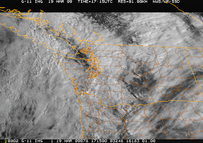
OK...that turned out not to be such a weak front. There was no indication in the models we would have such a sharp transition and with no coastal radar we could not see it coming. A convective line formed on the front with very heavy precipitation...take a look at the radar..you can see the reddish color of very intense precipitation. The observations at the top of the UW Atmos. Sci building shows the dramatic nature of the transition...substantial wind shift, sharp pressure trough, sudden drop of temperature and increase of humidity, and increase in winds to 30 mph (see figure). Or look at the Seattle profiler (image)...a very sharp shift from southerly to SW winds and big temp decline. Finally, you can see the line in the visible satellite imagery if you look carefully (image).

Weak Front

| comments

A weak front is moving through today...with good rainshadowing over Sequim and Port Townsend right now. It will move through this evening, with cooler air in its wake. Tomorrow should be mostly dry....which is unfortunate since I will be at the NW weather workshop all day tomorrow (info on this at right). Then another weak front Saturday night/Sunday AM, with a chance of showers on Sunday. Wish we had some exciting weather coming....nothing on the horizon.

Snow expose and other items

| comments

The Seattle Times has a nice story on the poor snow removal of the December 2008 snows. Check out:

http://seattletimes.nwsource.com/html/politics/2008885019_sdot19m.html

and KIRO TV is doing their storm special again at 10 PM.


Nice example of rainshadowing today NE of the Olympics (both in the radar AND the visible satellite picture). Those retirees in Sequim may be golfing in the sun right now, while I had to bike in in the rain! The models handle this kind of situation well...take a look at the 3-h precipitation ending 10 AM....

Cold Wave

| comments


Over the weekend and Monday I was busy giving public talks...but I am back again. Nice to meet several of you.

Many have complained about the cold temps...and in general we have seen substantially below normal temps during the past two weeks in western Washington. Above you see the temps for Seattle, Yakima, and Spokane...with the normal highs and lows shown. Except for one day, the Seattle max temps have all been below normal--most well below normal. Eastern Washington was cold early in the period, but the last few days have been near normal. On the 12th Spokane's temp fell to near zero, and Yakima had several days in the teens. It does look that a moderating period is ahead though.

On the road, several people asked me about the interpretation of the weather radar images...so let me try that a bit (see image). What is shown is reflectivity...a measure of how much the target (precipitation) scatters the radar signal (which is in the microwave part of the spectrum). Grey is drizzle (5-10), reds are light rain (15-25), green is moderate rain (30-35), and above that is either absolutely pouring...or wet hail. The concentric range circles are 100 and 200 km from the radar. If you look at the upper left corner you see some additional information. This radar picture is for an elevation angle of .5 degrees, which means the radar is canted slightly up from the horizontal. Thus, the beam is sweeping out a conical surface as it rotates...or in other words...the beam gets higher and higher the farther out it gets from the radar. How how? The second row of numbers tell you. The radar is at 196 meters, and the beam gets to 1068 and 1941 meters by the first and second range circles. That beam is way overhead by the time it gets to the south Sound for example. So shallow drizzle can be missed for such locations.
Now why don't we see the mountains on the radar? Special software remembers where the mountains out and removes that part. In the right corner you see max=44 ..that means the maximum reflectivity anywhere in the domain was 44.

Rain shows up better than snow on weather radar. And big raindrops show up better than small ones. Anyway, enough radar 101.

On Thursday night at 10 PM KIRO TV is repeating their hour-long special on the Dec 3-4, 2007 windstorm/rainstorm, if you are interested.

Snow

| comments


Snow piling up at Silverdale this morning (thanks to Dale Ireland cam)

Huge flakes are falling around the area right now. In the central Sound it is really not accumulating at the surface because the temps are too warm...but cams in the south sound show perhaps a 1/2 inch. It is much worst on the Kitsap and near Hood Canal...take a look at Dale Ireland's cam in Silverdale(attached). This is what the models were indicating last night. The precipitation is front a a warm frontal band associated with the incoming system and temperatures are just cold enough for very wet snow (see radar).The snow is full of large aggregates (many crystals stuck together)...that is why they are so large (the surfaces of the snowflakes are melitng and wet...and this acts as a sort of glue to allow them to stick to each other). This happens in marginal temp situations, like we have now.

The Seattle profiler temp soundings show how temps are just at freezing above us (subtract 1C from the values shown--this is actually something called virtual temp which includes moisture effects). Evaporation and melting of snow from aloft helped to push us over. Anyway, enjoy it...it won't last. The warm front will move warmer temperatures into us in a few hours and end the snow for everywhere except near the Olympics...and even there during the afternoon.Want to see where the warm front is at the surface..check out the surface obs and look towards the Astoria area....southerly flow in the upper forties on the N. Oregon Coast and easterly flow in the 30s along the central WA coast. The warm southerlies will move northward this morning.And later it will get breezy later today...although the latest model runs indicate the low will be crossing Vancouver island sufficiently north that Puget Sound will be spared the strong stuff.

9:30 Am..the air is warming rapidly aloft and it is raining...

PS: I am heading to Bainbridge today (Eagle Harbor Books) at 3 PM today to talk weather..and Olympia tomorrow (see info to the right). Will have to shovel my driveway first!
 
Support : Creating Website | Johny Template | Mas Template
Copyright © 2011. The Weather - All Rights Reserved
Template Created by Creating Website Published by Mas Template
Proudly powered by Blogger