Annular Eclipe Cloud Update

| comments

Sunday noon update:  the warm front is moving through and the rain is ending over western WA.  Some breaks and thinning of the clouds can be expected during the next few hours.


An annular eclipse--the sun is not completely covered by the moon
Tomorrow (Sunday) between roughly 5:30 and 7:30 PM PDT an annual eclipse of the sun will be occurring over the U.S. West Coast.  Even if it were clear, we (Washington State and northern Oregon) would only get a partial, off-center eclipse since the prime viewing swath will be south of us (see map).

 You can go to a wonderful eclipse calculator created by NASA (found here) to see what proportion of the sun is covered and when.  For Seattle, the answer was about 83% starting around 6:44 PM (time is in UTC/GMT).

Will you see it?  I don't have particularly good news, but I can offer a slight bit of hope.

Here is the official National Weather Service sky cover forecast for 5 PM Sunday:

If this is correct, then most northwesterners are in trouble...need to head down to far SE Oregon, CA, or Nevada.  But the NWS forecasts tend to be a bit broad brushed and smoothed.  That is why you come to this blog!

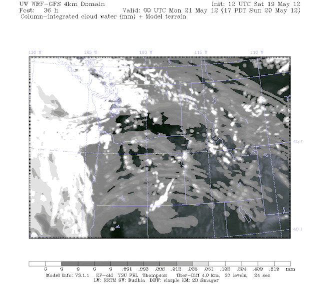
What about our latest WRF weather model runs?   Here is the predicted cloud liquid water integrated from the surface to the top of the atmosphere at 5 PM and 8 PM Sunday..  Bright white would be thick clouds, gray--thin clouds.  If you believe this, there is a CHANCE for a thinning of the approaching clouds along a swatch over the southern and eastern portions of Washington. 


We can also produce a simulation of what an infrared satellite image would see if the model solution was correct.  Here it is for 5 and 8 PM.  Lots of clouds, but there some gaps and thin spots.  Forget the coast.


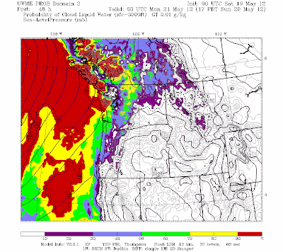
Finally, we have our ensemble prediction system that gives cloud probabilities.  Here are the probabilities of low clouds (surface to 3000 ft)--there still could be higher clouds above.  Clearly, the message is don't go to the coast or north.  Head south and east to improve your chances.

Bottom line:  a system is approaching tomorrow and there will be considerable cloudiness.   But there is a chance that some of you over the southern and eastern portions of the region might get lucky.   Or fly to Reno if you want to be sure!  Tomorrow afternoon go to the visible satellite animation (found here) and you will know the story.  


Mysterious Ocean Precipitation Under Clear Skies

| comments


For a number of days, starting on Friday, the new Langley Hill coastal radar has been showing lots of precipitation offshore, some if it heavy.  Yet the skies have been clear or nearly so.  Then on Wednesday the rain disappeared.  What is going on?   And let me warn you now...these mystery showers are going to come back!

First, let me show you what I am talking about...here are two radar images for 8:38 PM on Friday and 6:49 PM on Tuesday.  Lots of apparent rain offshore, but very little over land...very strange!


And lets compare these radar images to the visible satellite imagery at nearly the same time:


All that rain is not coming from clouds!  So if this is not some sort of alien intervention, there must be another explanation!  And there is.

Last weekend and early this week the land surface temperatures have been relatively warm, and most importantly the lower atmospheric temperatures have been warm.  But the surface temperatures of the eastern Pacific have remained quite cool--roughly 50F.   With warm temperatures aloft and cool sea surface temperatures, a low-level inversion (temperature warming with height) formed over the ocean.    We don't have a balloon-launched radiosonde over the ocean, but I can show you the simulated conditions from the UW WRF modeling system there.  The red line is temperature and you can see a shallow, cool marine layer surmounted by an inversion.
So why is this important?  It turns out that such low-level inversions can bend the radar beam downward towards the surface...we call this superrefraction (see figure).   Radar beams are generally bent a bit (refracted) by the normal atmosphere, but inversions greatly enhance this refraction, enough so that the bean is bent back to the earth.  In fact, under inversion conditions (like this weekend), the refraction is so complete the radar beam is trapped near the surface (this is called ducting).

It appears that the radar beam from the Langley Hill radar was not viewing precipitation in the air at all, but rather intersecting the sea surface and reflecting back!   The ducting allowed the radar beam to skim the surface for hundreds of kilometers. To see this, look at this radar image I got from my colleagues in the National Weather Service...the radar beam was hitting and returning from coastal terrain way down the Oregon coast.

This problem was only apparent for the lower radar scans (.2 and .5 degrees above horizontal).  For the higher scans..1.5, 2.5 and higher...there was nothing out there--consistent with the superrefraction mechanism.  Today I was on a conference call with NWS radar experts in Norman, Oklahoma.  They told us they had never seen such a profound, sustained superrefraction/ducting event...one for the record books.

The thing is, this is not the end of this issue.   When we get warm again, the mysterious ocean rain will be back.  The TV weathercaster folks will have to keep this in mind when they show the coastal radar imagery.


Annual Solar Eclipse Forecast

The event will be centered south of us, but the event will occur around 6 PM on Sunday.   Unfortunately, it looks like most of our region will be clouded over at that time.  Sorry.  Will update on Sunday AM. 


U.S. Climate Versus Weather Computers: Climate Wins

| comments

Why is the U.S. government provide hugely more computer resources for climate prediction than weather prediction?  And why is far more emphasis given to climate prediction research than weather prediction research and development?

In some past blogs I talked about the unfortunate lack of computer resources available to the National Weather Service (NWS), resulting in the U.S. trailing behind many international numerical weather prediction centers.  This lack of computer resources undermines the ability of the NWS to run high-resolution weather models, to move effectively into probabilistic weather prediction, to enhance hurricane prediction, and much, much more.  Far smaller nations, with much more benign weather, such as England and South Korea possess weather supercomputer facilities that dwarf ours.
The cost to the American people  of  inferior weather computer resources is substantial, both economically and in saving lives. 


While  U.S. operational weather prediction is provided inadequate computer resources, climate prediction, including studies of potential human-forced global warming, ienjoys the availability of huge supercomputers, with capacities hundreds of times larger than that available for weather prediction.

It is not a little ironic that great emphasis is placed on acquiring state-of-the-art petaflop supercomputers for climate change, while in a year of a dozen billion-dollar weather disasters, the NWS is not given critical tools needed to protect the American people.   Someone has their priorities wrong.

Let me give you a few examples.    As noted in an earlier blog, the National Weather Service operational computer system has 4992 processors for a total computational capacity of .07 petaflops (a petaflop is one quadrillion floating point operations per second).   Keep this .07 petaflop number in mind.

The new 1.1 petaflop GAIA computer just acquired by NOAA
Now consider a few of the climate computers purchased by the U.S. government and associated agencies.

Lets begin with the 1.1 petaflop GAIA computer recently acquired by NOAA, a machine sixteen times more capable than the NWS weather prediction computer.  This machine will be dedicated to climate research (see an article here on this machine).

The National Center for Atmospheric Research, an entity mainly funded by the National Science Foundation, is now completing a 70 million dollar facility that includes the new Yellowstone computer, capable of 1.5 petaflops.    This machine will be used mainly for climate research (article here).  A great irony is that this machine uses HUGE amounts of power, power that will come from coal-fired power plants that emit lots of CO2.

NASA Pleiades supercomputer
Or consider the new "Discover" supercomputer acquired by NASA's Center for Climate Simulation (NCCS) that has .32 petaflop capacity, nearly 5 times that of the NWS forecast machine.  The Discover machine is dwarfed by NASA's new "Pleiades" supercomputer (1.3 petaflops) that is being used for climate simulations and other NASA needs.

I could go on and on naming other supercomputers owned by the U.S. Department of Energy and others that are used for climate research--it would be a very long list.  The bottom line is that the computational power available for climate simulations, for understanding and predicting climate change over the next few decades to a century, absolutely dwarfs what is available for predicting the weather and for understanding how weather systems work.  

This makes no sense.

Imagine if one of the petaflop machines was made available for weather prediction.  The forecast skill of the U.S. global weather models could be substantially increased--providing skillful forecasts further out in time.  We could run models with enough resolution to get the fine scale structures of hurricanes and other storms.   A new age of probabilistic weather prediction could begin, with high-resolution ensembles providing uncertainty information for local weather features.  The impact would be huge, saving hundreds of millions or billions of dollars in economic impacts from severe weather, protecting lives, and improving the functioning of our air traffic control and highway systems.   Real and profound benefits.

Now don't get me wrong.  Understanding and modeling climate change is important.  But there are dozens of supercomputers in the U.S. that are quite capable of this task--and remember  that climate simulations don't have to be done within a set schedule like weather predictions.    And there are many groups around the world doing the same type of global climate simulations--and quite frankly all the better models get essentially the same results.  There is a vast overkill in pushing computer resources for climate prediction, while weather prediction is a very poor cousin.  And consider the fact that with all the supercomputers available for climate prediction, the uncertainty of the predictions for the next century has remained essentially unchanged.  The reason...adding more physics and interactions in the models adds uncertainty since the problem is getting more and more complex.

Why is this gross imbalance happening?   That is something I will leave to the comment section of this blog.  But it is clear that leadership in NOAA, the Department of Commerce, and in other Federal agencies have let this go on too long, to the detriment of the American people. Our congressional representatives and others need to intervene.  The U.S. Office of Management and Budget (OMB) needs to evaluate this situation more carefully.

And don't forget that improved weather prediction is critical for dealing with climate change.

Mankind is doing very little to stop anthropogenic global warming--we are going to do the experiment.   We are ALREADY doing the experiment.  Thus, adaptation will be critical and what is more important for adaptation than improved weather forecasts?  If climate extremes will increase under global warming we need to be able to predict them in the short-term to protect people and property.   Furthermore, there is no better way to improve climate models than to improve weather models, since essentially they are the same.  You learn about model weaknesses from daily forecast errors in a way you can't do in climate predictions.

Climate Computer Support
Weather Computer Support

We can do BOTH climate and weather prediction, but more balance in resource allocation is needed.

PS:  Probcast, the UW high-tech probabilistic prediction system (www.probcast.com), is back up!  The software is now on my department servers, so it should be far more dependable.

PS:: My lost dog was spotted in Mountlake Terrace (the person was pretty sure about this)-- near the intersection of 238th place SW and 52nd Ave.  If you live around, let me know if you see her!  (see right panel for more information)

Cold Records with Warm Temperatures

| comments

On Saturday it became toasty here in Northwest, with many locations gets into the 70s and lower 80s.  Yet a number of locations exprienced daily minimum temperature records in the morning--here is the proof from the National Climatic Data Center records website.  The blue dot indicate a tie for the record and stations with an x set a record.


To see what was going on, take a look at the vertical sounding at Spokane, WA for 5 AM on Saturday morning.  With high pressure we had clear skies (good infrared cooling) and light winds (less turbulent mixing of warm air from above).  Thus, air near the surface cools efficiently at night.  The air temperatures aloft have warmed considerably the past few days, much of it due to compressional heating from sinking air in the high.  Thus, we have had surface-based temperature inversions (temps INCREASING with height). During the day, the surface is heating from the sun and the warm air is getting mixed down to the surface, thus temperatures soar.


The combination of cold air at the surface in the morning, and warm air aloft that mixed down during the day, was a huge diurnal range between the high and low temperatures---concrete-cracking range.  Consider a few examples.  Pasco went from 32 to 79:  47 F change!
 While Olympia, went from 34 to 79.  45F increase.  A few stations exceed 50F.
I don't much about plant physiology, but I wonder how plants tolerate such temperature swings.

And happy mothers day....Moms may need a sweater in the morning, but a short-sleeve shirt will be mandatory this afternoon, as many enjoy highs reaching into the upper 70s and 80s.

Summer in May

| comments

It is a climatological oddity of Northwest meteorology that we often get a period of very warm, dry weather sometime in the second or third week of May, followed by a retreat into the dismal June Gloom.  Well folks, we are about to have the heat wave--one that will bring near 80F temps to Seattle, 85F to Portland, and near 90F in Medford.  The latest National Weather Service forecast for Seattle says it all:


The interesting thing is that for the last few days we have had fairly cold air over us, and with relatively clear skies and good radiational cooling to space, temperatures have fallen well below freezing in the cooler spots.  For example, it got down to 19F in Redmond, Oregon early Thursday morning---here are the minimum temps that morning...plenty of 20s and sever teens!
The was so cold aloft that considerable instability was produced as the surface was heated by the strong May sun....producing some impressive cumulus development.  Take a look at the UW cam image at around 7:30 AM and three hours later...you can see the destabilization due to surface heating:


During the next few days you will see progressive warming...lets look at the predictions by the UW WRF model for 5 PM on Friday, Saturday, and Sunday.  The light pinks and whites are in the 70s and higher.  You don't need to be much of a meteorologist to understand what this means....


White hot!   Clearly, the mothers in the NW are particularly deserving this year.  Amazingly, it s our fifth good weekend in a row.  And Monday will be warm as well.  Even your tomato plants will be happy.

Final reminder for those near Portland...I will be talking at OMSI Science Center in Portland at 10 AM, looking into the future of weather prediction.   The lecture is free, although the Oregon Chapter of the American Meteorological Society will be raffling off a fancy weather station and one of my books.   This chapter is one of the biggest and most active in the U.S. and recently they had some highly controversial sessions with both sides of the global warming debate.

The Windiest Place along the West Coast

| comments

As the U.S. West Coast enters the warm season, one area is getting very windy, particularly during  the afternoon and evenings.   Day after day this region will be hit by 20-30 mph winds, often with higher gusts.   A region, where the afternoon is often too windy to be on the beach, with wind-driven sandy stinging and making life unpleasant.  Give up?

It is the coastal zone stretching from southern Oregon into northern California, and out a hundred miles or so into the ocean.

Here is the sustained wind forecast of the UW WRF model for 5 PM this afternoon.  Notice the greenish area along the West Coast, with sustained winds of 30 kts or more?

Now examine the closer view from the 12-km domain.  Strong northerly winds stretch from just north of Brookings, Oregon (on the southern OR coast) to just north of San Francisco. You will also note a large change in sea level pressure over than area (solid lines), which has a lot to do about why we have strong winds there. 

So why the strong winds in this area during the warm season?  In the spring the East Pacific High strengthens and moves northward.   At the same time, the desert southwest of the U.S., warms and pressure falls.   So with rising pressure over the NE Pacific and falling pressure over the U.S. Southwest, an area of very strong pressure difference develops between them....over northern CA and southern Oregon.   Large pressure differences result in strong winds.

But as the infomercials always say, WAIT, THERE'S MORE!  The area of large pressure difference produces northerly winds over the coastal ocean, which in turns leads to upwelling...water coming up from below in the coastal ocean.  Those upwelling waters are COLD.  So we have very cold water offshore, and the land gets warm during the day.   The result is a large temperature gradient (peaking during the warmest time of the day), which enhances the pressure gradient even more, producing a super sea breeze.     So the morning is windy, but the afternoons are savage.

Lets take a look at the coastal winds for the past few days.  Here are the peak gusts at Buoy 46027...just offshore of the CA/OR border.  Wow...winds right now are gusting to NEARLY 45 knots (52 mph).


Or how about Cape Arago, Oregon (not far from North Bend)?  Almost 35 knots over land.  Can you imagine what that would be like on beach?   Similar winds are also found at Crescent City, CA (see below).


The northerly summer winds are so strong along the southern Oregon coast that a lot of trees are bent southward.  Want proof?  Check out this picture taken at Brookings:


I better stop before I get into trouble with the Brookings, Oregon Chamber of Commerce.  You might think this would be a good area for wind turbines, but the lack of transmission facilities and excessive strength of the winds might make it a poor choice.  But the cold water does help produce lots of coastal fog and that gives us the magnificent redwoods, which depend on fog drip for summertime water.


A reminder for those near Portland, Oregon...I will be giving a free public lecture on the Future of Weather Forecasting at the OMSI science center (more info to the right or here), at 10 AM on Saturday.

Soil Temperatures and Gardening

| comments

The question that many amateur gardeners like myself often ask is:

Why are my seeds not germinating and rotting in the soil?
When will the soil be warm enough to sow my seeds or transplant my plants?

Well, I don't pretend to be an expert in this, but I suspect it has something to do so with the temperature of the soil.

You can purchase or adapt a thermometer for taking soil temperature measurements
Lets talk about soil temperature and how this compare to air temperature, a subject that is interesting beyond gardening.

The first thing to keep in mind is that the temperatures you hear about on TV or read about in the newspaper are for the air temperature, in shade, at a height of roughly 2 meters (6 feet).   So when meteorologists talk about surface air temperatures...that is what we mean.  And such temperatures SHOULD be taken above native vegetation, which is increasingly rare.

Now the temperature of the ground surface is often quite different than the air temperature.  During sunny days, ground temperatures can be much warmer than the air temperature (10-40F is not unusual), and on a cold, clear winter nights, when the ground radiates heat to space, the ground temperature can be 1-8F cooler than air temperature.  After relatively warm periods, heat conduction from the warmed soil below can keep the surface temperature warmer than the air temperature at night.

Several of these characteristics are evident in this plot of surface and ground temperatures at the WSDOT road weather site at Silica Road (near Quincy in eastern Washington, along I90) for Sunday.  Time advances to the left in this figure.   The road temperature zoomed up to roughly 105F, while the air temperature was in the low to mid 60s!  Wow.  And last night the air temperature was cooler than ground temperature as the former dropped in the upper 30s.

 Such super-large temperatures changes just above road surfaces lead to the famous water on the road mirage (see my book for details on this).


Now what about the soil temperatures?  The deeper you go into the soil the weaker the daily temperature variation becomes, with the soil temperature increasingly  reflecting the average temperatures of the weeks and months before as one descends.  Here an example of the soil temperatures at roughly 1 inch (2.4 cm), 6 inches (15 cm), and 12 inches (30 cm).  Lots of daily variation in the top inch (in this case a range of 30F), but only a 2F range at 12 inches.  And you can see it takes a while for the warming to propagate down into the soil.   Go down 5 feet or so and the temperature hardly varies throughout the year.

So what are the current soil temperatures around the State?   Lets look at soil temps at 8 inches down from the highly useful Washington State University AgweatherNet .  Here are the values today...mid 50s over western Washington and the mid to upper 60s over the western portion of eastern Washington (60 and above are in yellow).

Now lets examine  the 8-inch deep soil temperatures in Seattle since January 1 (see graph).  A steady rise until the cold spell this week, and now it is rising again with the warmer days. Roughly upper 50s F.


 Ok, so what does this have to do with the germination of vegetable seeds....and particularly why my bean seeds are just rotting in the soil?

Take a look at the typical soil temperature required for germination of various seeds (see below).  Big variations.   Here in western Washington we are now good to go for corn, spinach, carrots, and peas (not shown, but ok at 50F).  But beans need soil temps in the 60s.  Boy did I make a mistake planting those too early!   Next time I will check the soil temperatures before I sow. 

Vegetables or not, soil and ground temperatures are fascinating, and during the winter knowledge about them can save your life when roadway icing is threatening.

Warmth Returns

| comments

You don't need to be a meteorologist to know that we have been substantially cooler than normal the past five days--on both sides of the Cascades.  Here is a sample from Seattle and Pasco.  Roughly 5-10F below normal on the max temps.
 The reason?  A persistent trough over the Northwest, as shown by this upper level map (500 mb).   You will notice that while we have a trough, the central/eastern U.S. has had ridging, and yes, their temperatures have been well above normal, a pattern we have


seen a lot of this spring. Here is the mean and anomaly (difference from normal) temperatures for the first three days of May.  We are cold and purple--that seems appropriate, purple for cold, and that is the UW Husky color.  The eastern U.S. is brown, with warm anomalies approaching 8F.


But this will change as ridging is now occurring aloft, as illustrated by the latest European Center upper air prediction for Sunday at 5 PM.   This ridging will hold at least through Monday, so expect lots of sun and much warmer temperatures on Sunday and Monday--in fact, many of you will be in the 70s Monday afternoon.

Here are the latest UW WRF model forecasts for surface air temperatures (remember these are for 2-m above the surface).   On Sunday, mid-60s on BOTH sides of the Cascades (except for NW WA and coastal residents near the water, sorry).

And 70s in that Willamette Valley, a natural hot box due to its isolation from the ocean influence.

But as good as Sunday will be Monday will be spectacular, with seventies extending to Seattle and the torrid Willamette Valley getting near 80F. 

Finally, let me end by noting that we have had strong Puget Sound convergence zones over the past few days, with some being unusually broad.   A few samples from the Camano Island radar for your amusement.   The nice thing about such situations is that you know where to go to escape the rain.


Let me end with a reminder that I will be giving a talk in Portland (OMSI Science Museum) at 10 AM on Saturday on the future of NW weather prediction.  More info to the right.  I will bring a few books to sign as well.


Pioneer Weather Complaints

| comments

Some things never change.

One can not be considered a Northwesterner if you don't grouse about our endless cool, showery weather during Spring.  And it turns out that our pioneer ancestors---more than 150 years ago--were doing the same thing.

Let's go back to 1855 and the town of Steilacoom on Puget Sound's waters.  In a hard-hitting commentary in the Puget Sound Courier published at the end of May,  Honest John Tompkins chastised his fellow citizens for their "growling" about the weather.


He noted that Spring 1855 started out well:

"Throughout the almost entire month of March last, the people everywhere in the Territory, were rejoicing at the beautiful summer-like weather ... Every one seemed to be perfectly happy and contented, and there was not a countenance to be met with between the Columbia River and the Straits of Fuca, that was not the index of a joyous heart."

But then the weather shifted:

"Well, March went out, April came in, and with it, cold, wet, disagreeable weather, and a universal spirit of discontent, and a disposition to "growl""

"Throughout the entire month, and even up to this, the last day of May, it has been precisely the same, and some amongst us profess to be so thoroughly disgusted with the weather .... that they threaten to leave the Territory altogether."

Well, I have heard that one before....people threatening to move to California or some other warmer clime! 

By the end of May the weather had improved and Honest John made the false claim I have heard so often....the idea of balance...if the weather is bad for a while, it will surely be good later (and vice versa).  That some kind of omnipotent weather god is ensuring that the yin and yang of weather will be in rough equilibrium.   Sounds profound and true.  It isn't.  And I must admit I have heard some TV weathercaster types saying the same kind of thing.

"Is it not fair to presume or reasonable to expect, that there will be a large number of wet disagreeable days in the Spring, if there be but few in the Winter, the season in which it was natural to expect them? Most assuredly. And again, now that really fine weather has broke upon us---may we not reasonably anticipate, for a series of months, the same clear and bracing atmosphere, the same un-cloudy days, and deliciously cool nights for which the summers of Washington Territory are so justly and widely celebrated?"

Then Honest John takes on God's work in putting the complainers in their place.  The kind of work I try to model in my blog.

"Men from New England... You have "growled" a good deal at the weather this Spring, have you not?  ... a few short years since, among the bleak hills of your native States, you shivered beneath the fierce Northern blasts that swept from their summits, for five long winter months in each, and then that for three more you were almost constantly subjected to those damp, unwholesome, and consumptive-engendering fogs which are driven by the raw East winds, from "Newfoundland's Banks" into every "nook and corner of the Northeastern section?" 

I wish I could write like that.  "Damp, unwholesome, consumptive-engendering fogs"!!

And then he took out the heavy guns for those from the warm, tropical southeast:

"Men from the "sunny South!"...  for you are ... no freer from blame. Has not the truth many times occurred to your minds ... that the enervating influence upon both mind and body of your own tropical climate, and the sluggish vapors arising from your extensive swampy lands, impregnating the entire atmosphere with contagious diseases, are more to be feared and deprecated, than the rains and comparatively cold weather of Washington Territory"
Early Steilacoom
 He ends his reproach to complainers by noting:

"let us have no more of your foolish and wicked repinings at the season." 

Wise words for all of you to remember.

But some of you insist on complaining.  Surely, the spring of 2011 was worse than any of ancient memory.   Fine, let's check the numbers, with the assistance of Mark Albright, past State Climatologist.

The average temperature in 1855 for April/May was 51.6 F at Steilacoom which lies between SeaTac and Olympia. The April/May 2011 mean temperature averaged over SeaTac/Olympia was 48.0 F, considerably cooler than Steilacoom experienced 157 years ago in 1855. The coldest April at Steilacoom over the 19 years between 1850 and 1868 was 45.2 F in 1859. This is warmer than the 44.6 F recorded in April 2011 at SeaTac/Olympia.  (Please...no global warming skeptic comments!)

So complainers among you take heart...last spring's cool/dampness was far worse than the weather that unsettled our tough, stout pioneer ancestors.  

This spring is a pussycat in comparison.


Support : Creating Website | Johny Template | Mas Template
Copyright © 2011. The Weather - All Rights Reserved
Template Created by Creating Website Published by Mas Template
Proudly powered by Blogger