Snow expose and other items

| comments

The Seattle Times has a nice story on the poor snow removal of the December 2008 snows. Check out:

http://seattletimes.nwsource.com/html/politics/2008885019_sdot19m.html

and KIRO TV is doing their storm special again at 10 PM.


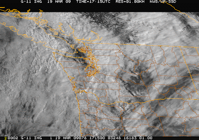
Nice example of rainshadowing today NE of the Olympics (both in the radar AND the visible satellite picture). Those retirees in Sequim may be golfing in the sun right now, while I had to bike in in the rain! The models handle this kind of situation well...take a look at the 3-h precipitation ending 10 AM....

Cold Wave

| comments


Over the weekend and Monday I was busy giving public talks...but I am back again. Nice to meet several of you.

Many have complained about the cold temps...and in general we have seen substantially below normal temps during the past two weeks in western Washington. Above you see the temps for Seattle, Yakima, and Spokane...with the normal highs and lows shown. Except for one day, the Seattle max temps have all been below normal--most well below normal. Eastern Washington was cold early in the period, but the last few days have been near normal. On the 12th Spokane's temp fell to near zero, and Yakima had several days in the teens. It does look that a moderating period is ahead though.

On the road, several people asked me about the interpretation of the weather radar images...so let me try that a bit (see image). What is shown is reflectivity...a measure of how much the target (precipitation) scatters the radar signal (which is in the microwave part of the spectrum). Grey is drizzle (5-10), reds are light rain (15-25), green is moderate rain (30-35), and above that is either absolutely pouring...or wet hail. The concentric range circles are 100 and 200 km from the radar. If you look at the upper left corner you see some additional information. This radar picture is for an elevation angle of .5 degrees, which means the radar is canted slightly up from the horizontal. Thus, the beam is sweeping out a conical surface as it rotates...or in other words...the beam gets higher and higher the farther out it gets from the radar. How how? The second row of numbers tell you. The radar is at 196 meters, and the beam gets to 1068 and 1941 meters by the first and second range circles. That beam is way overhead by the time it gets to the south Sound for example. So shallow drizzle can be missed for such locations.
Now why don't we see the mountains on the radar? Special software remembers where the mountains out and removes that part. In the right corner you see max=44 ..that means the maximum reflectivity anywhere in the domain was 44.

Rain shows up better than snow on weather radar. And big raindrops show up better than small ones. Anyway, enough radar 101.

On Thursday night at 10 PM KIRO TV is repeating their hour-long special on the Dec 3-4, 2007 windstorm/rainstorm, if you are interested.

Snow

| comments


Snow piling up at Silverdale this morning (thanks to Dale Ireland cam)

Huge flakes are falling around the area right now. In the central Sound it is really not accumulating at the surface because the temps are too warm...but cams in the south sound show perhaps a 1/2 inch. It is much worst on the Kitsap and near Hood Canal...take a look at Dale Ireland's cam in Silverdale(attached). This is what the models were indicating last night. The precipitation is front a a warm frontal band associated with the incoming system and temperatures are just cold enough for very wet snow (see radar).The snow is full of large aggregates (many crystals stuck together)...that is why they are so large (the surfaces of the snowflakes are melitng and wet...and this acts as a sort of glue to allow them to stick to each other). This happens in marginal temp situations, like we have now.

The Seattle profiler temp soundings show how temps are just at freezing above us (subtract 1C from the values shown--this is actually something called virtual temp which includes moisture effects). Evaporation and melting of snow from aloft helped to push us over. Anyway, enjoy it...it won't last. The warm front will move warmer temperatures into us in a few hours and end the snow for everywhere except near the Olympics...and even there during the afternoon.Want to see where the warm front is at the surface..check out the surface obs and look towards the Astoria area....southerly flow in the upper forties on the N. Oregon Coast and easterly flow in the 30s along the central WA coast. The warm southerlies will move northward this morning.And later it will get breezy later today...although the latest model runs indicate the low will be crossing Vancouver island sufficiently north that Puget Sound will be spared the strong stuff.

9:30 Am..the air is warming rapidly aloft and it is raining...

PS: I am heading to Bainbridge today (Eagle Harbor Books) at 3 PM today to talk weather..and Olympia tomorrow (see info to the right). Will have to shovel my driveway first!

Approach low and winds

| comments

Today was the kind of typical Seattle weather that has been nearly absent this year, wet, showery, and windy. Makes you feel normal again. A front is moving through now and the rain should back off soon. But the real fun is later tomorrow afternoon.
A developing low center will approach tomorrow afternoon and move north of us around dinner time (see attached). As a result, rain will come back in late tomorrow morning and the winds should pick up during the afternoon...peaking between 6 and 10 PM. Some locations could see gusts to 50 mph, such as over the Sound and waters of NW Washington. As the low moves past strong westerly winds could develop in the Strait (see graphic).
And did I mention the snow? Yes, the mountains will get loads of it...but tomorrow morning, a low freezing level and southeasterly winds could leave the western Kitsap in several inches of snow (graphic).

Major Weather Changes Coming

| comments

Today will be the last sunny, dry day for a long time. You can see the changes aloft as thin cirrus moves in aloft and contrails fill the sky. Contrails are a real sign of an approaching system since the air has to be close to saturation for them to form...the extra water vapor from combustion supplies the water needed to produce saturation and cloud droplets.
A weak front will approach tonight....and rain should start in the lowlands after midnight. The front should get through around breakfast time and then there will be a few hour break before the next...and stronger...frontal system moves in. Both of these fronts will bring considerable snow to the mountains. Colder air will move in behind the second front on Saturday night...and a few snow showers could reach the lowland hills on Sunday AM. But no big accumulation.
On Sunday, a low center will approach from the SW and this will bring more rain to the lowlands and snow to the mountains on Sunday afternoon. The low will bring strong winds to the northern Oregon coast and then breezy conditions over the Puget Sound lowlands on Sunday night.
The rest of the week remains cold and wet..with the mountains picking up lots of snow.

How Snowy? How cold?

| comments

The National Weather Service released some interesting snow statistics yesterday....this winter was the snowiest since 1971-72 and the 8th snow-filled on record.

TOP TEN SNOW YEARS AT SEA-TAC (OCTOBER 15 - APRIL 15)

SNOWFALL SNOW YEAR
67.5 1968-9
63.6 1949-50
27.4 1950-1
26.9 1971-2
24.2 1955-6
23.3 1953-4
22.9 1965-6
22.8 2008-9 (35 DAYS REMAINING)
21.4 1948-9
20.3 1985-6

As of 11 March, 2008-2009 now ranks as the 4th snowiest year in
Spokane with 88.9 inches of snowfall. Only 4.6 inches more snowfall is
needed to become the snowiest year on record, but normal snowfall for
the remainder of the season appears to be about 2 inches, so we are
fast running out of time. Last year (2007-2008) was the 2nd snowiest
on record with 89.5 inches, so 2nd place is easily within reach.

and what about cold records?

Mark Albright noted to me that Meacham OR recorded unusually cold minimum temperatures of -11 F and -12 F the past two mornings (11-12 March 2009). Coop records were maintained at the Meacham airport from 1948 to 1976. During that 29 year period the latest subzero reading was -4 F on 5 March 1955.

Spokane yesterday(11 March 2009) reported a low temperature of 2 deg F! The only comparable temperatures in the historical record are the 3 deg on 13 March 1897 and 2 deg on 6 March 1891, over 118 years ago.

Deer Park (KDEW), 30 miles north of Spokane, reported a low temperature of -12 deg F yesterday, with 10 consecutive hours below zero! The Deer Park 2E coop site which ran from 1911-1977 never reported a temperature this cold so late into March. The coldest this late into March had been -8 deg F recorded in 1943 and 1950.

Other subzero cold spots yesterday were the Freestone Inn at Mazama with -1 F , and in the next valley north, Princeton BC in the Similkameen Valley reported -13 F the day before yesterday and -9 F yesterday. The Mazama coop site, where records extend back to 1950, has never experienced subzero cold this late into March.

But please! No comments about all this disproving global warming! One year means nothing.


PS: I will be on the road this weekend giving some talks"

Sunday, 3 PM, Bainbridge Island, Eagle Harbor Books
Monday, Olympia:

noon, Olympia, General Administration Building, sponsored by Olympia State Capitol Museum, NW Weather and Climate lecture and signing
South Puget Sound Community College, Olympia, reception 5 PM, lecture 7 PM, Kenneth J. Minnaert Center Fine Arts Auditorium, small suggested contribution

Coastal Weather Radar Receives Partial Funding

| comments


All, this is a big day for the local meteorological community and for the citizens of the state....2 million dollars for the coastal weather radar was in the omnibus spending bill passed by the Senate yesterday--and President Obama will sign it. For years the Northwest has been the only coastal area of the continental U.S. without weather radar coverage...perhaps this day will soon be over.

Major credit for this advance should go to Senator Maria Cantwell, who has been a champion of the radar acquisition, and who worked to get this item in the appropriations bill. Senator Cantwell's staff has also been very supportive, as have been other members of our Washington delegation. The radar will cost more than this amount (roughly 4 million for the hardware, plus installation and maintenance), but this is a major down payment. Hopefully, we can get a contribution of the land needed for this facility or install it on public property, and the additional appropriations that will finish the job (or perhaps NOAA could use some of the stimulus money it was given for infrastructure improvement to make this happen this year!). Many of us hope that Gary Locke, now secretary of commerce and someone certainly well acquainted with the problem, will intervene since NOAA and the NWS are under his authority.

Anyway, in this period of uncertain news, it is nice to have something very positive occur.

In 2001 we had a radar on the coast for 2 months, attached is a teaser image, showing you what we could see. In that image you can view an offshore front approaching...a feature invisible in the current radar at Camano Island (whose beam is blocked by the Olympics).

The Geography of Cold

| comments

This morning it was mightly cold out there...particularly as I biked into work. But such cold varies greatly over the area, particularly on cold mornings in winter when the winds are light. This morning was a good example (see map). At 8 AM the temps varied from the upper teens in the western foothills of the Cascades to the mid-30s over Puget Sound. The range of temperatures were somewhat limited last night by the considerable cloudiness, that lessens the ability of the surface to radiate heat to space. Thus, on some nights the range of temperatures are even greater. In my NW weather book, I describe a night when five cars of UW students and staff drove around the region in instrumented cars. We found temperatures ranging from 25 near Maple Valley to 45 near the sound. Temperatures were several degrees cooler in valleys that were only 50-100 feet lower than the crests. Tomorrow morning should be just as cold, with temps certainly getting into the mid and lower 20s. My rhodies are not doing well.
The models are in agreement that conditions should stay dry until this weekend, when some frontal systems will approach, bring rain and warming conditions. But the real excitement may be early next week, when some models are suggesting a potential pineapple express period..with heavy rain in the mountains.
F

A New Weather Survey

| comments

A month ago, we had a weather survey designed to help us understand how people deal with weather forecast uncertainty. This was valuable information, but now we have a follow up. Only take this survey if YOU did NOT respond to the survey in January! We will post results in the next couple of months from both surveys.

Here is the link, but don't try it if you did the last survey...it will mess up the statistics!

We have all the responses we need right now...thanks for all your help...

PS: Several people have asked me whether Costco still has copies of my book. The answer is yes. Unfortunately (for me), they highly discount the book....about the same as Amazon.

PS: Weather is over until this weekend...

3 PM Snow Story

| comments


The northerly arctic air is now pushing south past Seattle, with clear skies behind. At its leading edge there is a wintry mix...particularly over the eastern suburbs (see radar and satellite). Sunny, dry conditions are found behind. So if you are north of Seattle..the game is over. Protect your plants.

snow update

| comments

If it is going to snow signficantly in Seattle and the adjacent lowlands--it will be later this afternoon as the low rotates southeastward. This morning Seattle was rainshadowed by the westerly winds....and the eastern suburbs and foothills areas got a few inches. But as the low moves over (or even better south) of us the rainshadowing will weaken and the northerly winds will strengthen...that is when we will get it. You can see the enhanced cloud over the NW Olympic Peninsula...associated with the low..moving this way. The game is not over yet...although there are no guarantees here...

Snow showers

| comments


Some snow showers are moving through the area...except for the northern Sound area, which is in the rainshadow (now snowshadow) of the Olympics. The rainshadow is there because the wind are from the southwest aloft. Northerly winds will push southward today and showers will be enhanced at and north of that interface, aided by a weak upper level shortwave disturbance. Don't expect a major snowstorm, but an inch or two is possible.

More snow

| comments


This is really quite extraordinary. We could actually get more snow tomorrow. Continental air is now moving through the Fraser (see map)...the sign is the low dewpoint...very dry air. But the big push comes tomorrow morning. The computer models show a great strengthening of the cold flow through the Fraser and lower terrain tomorrow morning between 7 and 10 AM, and that this air will push southward into Puget Sound. This push of cold is being initiated by a disturbance aloft...warmer, moister air will rise over the cold air producing light snow over the Puget Sound lowlands that could add up to a few inches (see map). I hate to say this...the TV types will go crazy. This is not certain, but now looks more likely than not.

Arctic air in March

| comments

Yesterday was a fairly successful day for the forecasting community, and the NWS forecasts of light snow amounts with the CZ were on target. The predicted heavy snow fell in the mountains...and the radar really helped us follow the action over the lowlands. Do you see how valuable having the radar is? Isn't it clear why the coastal zone, with its extraordinary active weather needs it? Isn't it outrageous that they don't? Well, you know how I feel about it. My other pet peeve...the failure of Metro's bus tracker software during snow periods when the hit rate climbed...appears to be on the way to being fixed, according to Metro management who emailed yesterday with their assurances that this problem will be addressed before next winter.
A look at the latest satellite pictures shows that shower activity is greatly reduced particularly over the northern portion of western Washington. Mountain snow showers have also declined. The radar shows the weak remnant of the convergence zone across Whidhey and northern Snohomish counties, and some showers basing eastward south of the Olympics. All snow showers.
The next stage in this event will be the movement of much colder air into the region...first evident as gap flow starts to push through the Fraser gap later today...so in Bellingham and NW Washington, the cool northeasterlies should come in late today and tomorrow AM..with some snow showers possible on its leading edge. I have included a prediction for sea level pressure, temp, and wind for 2 PM, you can see the cold air and higher pressure to our north. Upslope snow showers on the NE side of the Olympics should occur tomorrow..but at this point they look light due to the dryness of the air. Monday AM and particularly Tuesday AM should be very cold..perhaps record breaking, with minima in the 20s. So protect those sensitive plants. Tuesday and Wed a major ridge develops over us for sunny, cool and dry conditions.

Finally, for all of you who look at weather charts and obs, remember we are in PDT now and the difference between GMT (UTC) and PDT is 7 hours.

Convergence Zone snow hits I90

| comments


My son is turning back from his trip to Snoqualmie Pass for his snowboard lesson. The reason....too much snow and chains are required. The convergence zone has moved south and is now aligned nearly NW-SE...with the heaviest amounts aligned on I90 at and west of the Pass. The radar shows the story...and look at the cam up there--snowy driving. Convergence zones can greatly enhanced the snow at Stevens or Snoqualmie...depending exactly on how they set up. Outside of the convergence zone, some of you getting bright sunshine (see high res sat picture).

The heavier showers are now approaching western Washington....
 
Support : Creating Website | Johny Template | Mas Template
Copyright © 2011. The Weather - All Rights Reserved
Template Created by Creating Website Published by Mas Template
Proudly powered by Blogger