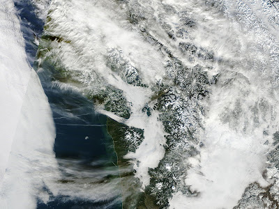
This is an ultra-high resolution image from NASA Aqua satellite....much better quality than the NWS geostationary satellites I have shown you in the past...but only available twice a day (click on the pic to see it better). You can see so clearly the low clouds over Puget Sound and eastern Washington. Look carefully and you can see fingers of low clouds pushing into mountain valleys..and even some contrails over the ocean. Also Tiger Mountain and the Issaquah Alps are apparent sticking out of the murk.
It really has been cold the last few days in the lowlands...with a lack of sun due to the low clouds. Take a look at the temps during the past two weeks (see figure). You can see that the temps the last two days has been hanging around the normal minima.

I am heading up Tiger Mt. Sunday morning..perhaps I will see some of you...want to experience some sun and warmth myself.
PS: I will be at UW Bookstore at 1 PM if anyone wants to talk in person.


