The transition to meteorological summer in the Northwest.
Often, as in this year, it happens right after July 4th, and almost certainly by mid-July, resulting in the oft-noted statement by the meteorological cognoscenti that summer starts on July 12th in western Washington. The effect is so profound, repeatable, and abrupt that we see it clearly in the climatological data. For example, here is the climatological daily probability of precipitation for Sea-Tac airport. On July 1st, the probability of at least .01 inches is still around 30%---but then the bottom drops out, and by mid-month it is in the low teens and around August 1st below 10%. Folks, this golden time, between July 15th and August 15th, is when you should plan your outdoor weddings, barbecues, and other rain-sensitive activities. Few areas are as dry as we are during that period.
But what about this year? Today and tomorrow there will still be come showers and clouds around. Wednesday, July 4th, will be the transition day, but one that should be dry--particularly around fireworks time. And then we transition to meteorological nirvana, as the persistent trough over the NW moves offshore and ridging develops over western North America.
Let me show you.
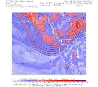
Here are two upper level (500 hPa--roughly 18,000 ft) charts. The first is for the afternoon of July 4th and the other for Sunday afternoon. You can see a large transition from a trough off the the west coast to ridging (higher heights) over western North America and strong troughing far out in the Gulf of Alaska.
This transition in atmosphere flow is supported by most major international model systems, such as the gold-standard ECMWF forecast... as shown below.
For longer-term forecasts meteorologists depend more heavily on ensemble-forecast systems in which many forecasts are run, with the ensemble mean (average) having more skill than any particular forecast. And the variability of the ensembles gives us information about probabilities. Here are the differences between the forecast ensemble means for today versus Saturday (actually the differences of the forecast means from normal..the anomalies) for the upper level (500 hPa) flow. Blue indicates anomalous troughing, green-ridging. The ensembles concur with the transition to improved conditions.
So, get our your summer clothers, buy that sunscreen, be prepared to water your garden...summer is coming.


