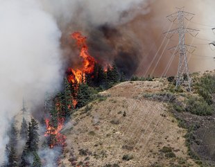
Smoke has filled much of the Northwest today, and we didn''t need any Asian smoke to assist. The latest MODIS satellite image shows a huge quantity of smoke over California and southern Oregon from local wildfires, and, of course, there is the rapidly growing Taylor Bridge fire between Yakima and Ellensburg (see below). This fire grew explosively during the past 24-h and now encompasses more than 25,000 acres. A big part of the problem has been the winds...which have gusted to 40-50 mph in places.
Here is close up of the Cle Elum/Ellensburg area...you can see the smoke...although it is a bit subtle.
Why did it explode so quickly and why am I hopeful that the driving winds will eventually decline?
The Cle Elum to Ellensburg area, as most of you know, is a very windy corridor during much of the warm season. It is downwind a major weakness in the Cascades that meteorologists often call the Stampede Gap. During a normal summer day, when high pressure dominates the eastern Pacific and lower pressure is inland, westerly winds can blow quite powerfully through the Stampede Gap into Cle Elum and down into Ellensburg. That is why there are so many wind turbines there. But the problem is that IF a fire gets started that winds can cause them to spread rapidly and explosively...and unfortunately that has happened. In some ways, this is one of the WORST places to have a fire because of the strong gap winds of the area.
Here is the pressure and winds of the past two days for around 5 PM. Classic westerly wind pattern.
Take a look at the surface (actually 30 ft) winds from the UW WRF model for 5 PM today. You can see the strong winds in the Stampede Gap and downstream.
The winds at the Ellensburg Airport came up yesterday and are still quite strong:
 |
| Ellensburg Sustained Winds |
 |
| Ellensburg Gusts |
But I am hopeful the winds will weaken around the fire, giving the fire folks a chance to bring it under control. Why? Because of the upcoming western Washington heat wave! A thermal trough will move up the coast and will result in a weakening and then reversal of the pressure gradient. Here are the forecast maps for the next two days at 5 PM to show you what should happen:
Beautiful thermal troughs and a big warm up for the west side. Low pressure moves to the west side of the mountains! As a result, the westerly winds will end overnight, being replaced by weak easterlies. Hopefully, that will enable the firefighters to get this explosive blaze under control.
Orcas Island Talk on August 29th
I will be giving a talk: Global Warming, Separating Truth from Hype at 5:30 PM on August 29th at the Orcas Center Madrona Room.


