 |
| 4AM |
 |
| 6AM |
 |
| 8AM |
 |
| 10AM |
 |
| Noon |
The forecasts seems quite solid...a few inches in the north sound, 2-4 inches around Seattle at low elevations, 6-10 inches around Olympia and south Sound, and MUCH more south of Olympia and north of Portland. Some extraordinary snowfalls around Napavine and nearby SW Washington areas--reports of 15-20 inches on the ground.
The warm front has moved northward up the Oregon Coast--warm and rain in Astoria and Portland. Long Beach (LONG2) was deluged with 1.6 inches of rain in just 5 hours between 4 AM and 9 AM as the warm front approached. During that time the temperature rose from 34 to 50 F. Now that's a warm front.
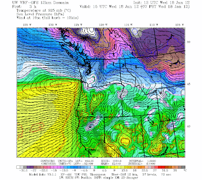
With the low moving towards the Oregon/WA border a huge pressure gradient has been created along the Oregon coast...with hurricane force winds from the south (see graphic).
Winds gusts to 99 mph at Point Blanco and above 60 mph at many locations.
And there is strong Fraser gap outflow winds moving in NW Washington (see graphic),
with true arctic air pushing to the SW. 12F in Bellingham with 20 kt winds! A lot of this flow is slamming into the Olympics, provide enhanced snowfall near Port Angeles and environs.
Once the precipitation is over this event is done...and tomorrow's system is going sufficiently south that precipitation will only reach to Olympia. Rain and warmer on Friday, washing the whole business away.


