In much of the U.S. it is called Indian Summer. In France the term is St. Martin's Summer, while in eastern Europe Old Ladies Summer and Gypsy Summer are often used. All of these names describe a warm period in the autumn that follows a period of cool weather-- in fact, some demand a killing frost before the warmth. Well, we don't get too many killing frosts west of the Cascades in autumn, so the term Indian Summer here is usually reserved for periods in mid-fall when the temperature rise to summer-like levels*. And we have real shot of this on Tuesday of next week.
Well, let me first document that we have had some cool weather--in fact the last two weeks have generally been cooler than normal, and last night there was a real chill in the air (I know about this personally, I was out searching for my lost dog in Mountlake Terrace). Here are the temps at Sea-Tac airport compared to the normal highs and lows:
During the last two weeks only one day had max temps above normal and most were far below. Today will be another cool one. But this will change in a big way.
Today (Friday) there will be considerable clouds and some light sprinkles, particularly in the central Cascades.
Saturday will be sunny and warmer...very nice...but you won't mistake it for summer--Indian or otherwise.
Sunday a weak trough will bring cooling and lots of clouds (maybe a bit of sun)
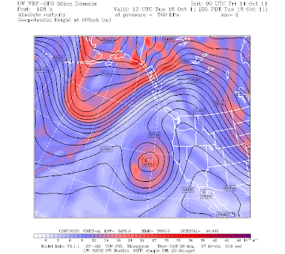
But Monday starts the warm-up and Tuesday it will be in full bloom. Want to see some weather maps? (of course you do!) Here is the upper level (500 mb) chart for Tuesday morning at 5 AM. Wow...big ridge over us...and a trough over CA that is working its way north.
Here is the sea level pressure, surface winds, and lower atmosphere temperatures at the same time. Good offshore flow with higher pressure east of the Cascades and lower pressure west of the mountains. You will notice a low pressure area near the Oregon/CA border.
With offshore flow, there will be virtually no clouds and air will be compressed as it sinks from higher elevations. Here are the predicted surface (really 2-meter) air temperatures at 2 PM on Tuesday. Temperatures above 70F over land, particularly on the eastside of western Washington and along the coast, downstream of the Olympics. Expect the warmest temperatures in the foothills...like North Bend and Issaquah.
Western Washington is warmer than eastern Washington in such situations.
So get your bathing suit ready, Tuesday will be your day. I suspect this will be our last excursion into the 70s this year...better enjoy it.
* Sequim dropped below freezing on Wednesday night.
This blog provides forecasts weather or other topics
Subscribe
Popular post
-
I didn't want to mention this, worrying I might jinx it, but it is clear that August 2012 will the driest in Seattle history. So far we...
-
Your plants know it, and so will your water bills if you have a garden. Over western Washington most places have not seen rain in roughly f...
-
Today was very warm around western Washington, with some stations (like Sea Tac ) breaking their all-time daily record. Now let me make one...
-
Wed Morning Update: The pressure differences across the mountains have weakened and the winds of Ellensburg have died down. Temperatures t...
-
It is not unusual during summer to view a satellite image like the following, with a narrow sliver of low cloud along the Northwest coast. ...
-
Well, one thing a forecaster learns quckly is humility. There is a weak upper level disturbances that is causing this light precipitation. ...
-
Click on picture for Dale Ireland's time lapse movie of today's action. Its cold, windy, with heavy rain in places. Convective show...
-
The front made it in late this afternoon and early evening as shown by the infrared satellite photo above. Winds really increased this afte...
-
A weak cold front is now moving into western Washington (see satellite and radar) imagery...with increasing clouds and a few light showers o...
-
A week ago I received an unusual call from Eric Swansen, Managing Director of the Regional Animal Services of King County. He had looked at ...
Blog Archive
-
▼
2011
(211)
-
▼
October
(15)
- Nor'Easters versus Northwest Windstorms
- The Most Dangerous Weather Phenomenon in the North...
- The Truth About Wind Chill
- Transforming Seattle Public Schools
- Jet Stream Weather
- Winning Meteorological Roulette
- Heat Surge
- Is Sequim the Sunniest Place in Western Washington?
- Indian Summer
- Tale of Two Radars: Rainshadow and Windward Enhan...
- Its All in the Timing
- Is West Coast Weather Getting More Extreme?
- Western Snow Season Begins
- Visibility Loss at Daybreak
- Sometimes a forecast goes wrong..
-
▼
October
(15)
Powered by Blogger.
Support :
Creating Website | Johny Template | Mas Template
Copyright © 2011. The Weather - All Rights Reserved
Copyright © 2011. The Weather - All Rights Reserved


