(1) Ensemble of predictions starting with different initializations (different starting points from major operational centers around the world) are producing similar forecasts (that was not true over the weekend).
(2) The forecasts from the National Weather Service models have settled down and are not changing much, cycle to cycle. There is only a slight drift north with the latest run (which makes it warmer by the way)
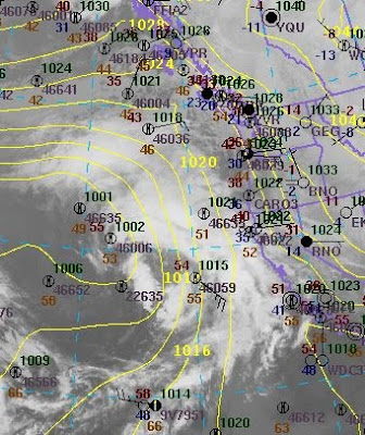
(3) A comparison of satellite imagery and observations with a model short-term (3-h) forecast looks good. No major errors in initialization or features. Here is the graphic for 7 PM (yellow are 3-h forecast pressures):

Don't be deceived, the low pressure center is NOT in the middle of the swirling clouds.
I think we have a solid forecast to work with, based on all the tools of the trade.
So, what will happen?
Today we had air that was just cool enough for snow over us and there was some light snow in a few showers that moved through this morning. No big deal.
Tomorrow the low will move northward towards Vancouver Island, with the attendant warm front moving up the coast with it. Here is the forecast surface chart at 7 PM:
 Warm air is already sneaking in (greens and yellows) at this time . And there is another problem for snow lovers on the east side of Puget Sound and Seattle--easterly downslope flow off the Cascades--the snoweater! Here are the winds for 7 PM tomorrow:
 See the easterly flow...this is bad news for snow..the descending air dries and warms. With low pressure offshore flow through the Fraser, relatively weak to start with, is moving our the Strait. Strong winds over the Pacific!
As the low and front reach us and move northward, there will only be a short period of possible snow. Cold air will be in place, and initially evaporation and melting of the falling precipitation will help keep it cool enough to snow. But eventually the profound warming aloft will win.
Here is the forecast 3-h snow at 7 PM. Some light snow along the north coast and NW Washington as well as the Kitsap region SE of the Olympics. Seattle will see a dusting. Certainly possible to be as high as 1 inch or two. And that of course would be slippery.
 Next, take a look at the surface chart at 4 AM. The low is making landfall on N. Vancouver Island and warm air has spread across western Washington. No more snow. Rain will pick up and so will the winds. The winds will strength further as the low loves north of us--20-30 mph gusts are reasonable over central Puget Sound.
 Here is the 24-h snowfall ending 4 AM Wednesday. Lots of snow over the N. Cascades and the Olympics. NW Washington gets a few inches, but not much south of Everett over the lowlands. Sorry.
 Freezing levels will rise quickly and temperatures in the lowlands will return to the 40s. The Olympics and Cascades will get crushed with snow...Mt. Baker could easily get THREE feet. And two other Pacific lows are lined up to follow this one.
Finally, I really appreciate all the feedback today on the value of long-term forecasts. I agree that it is important for people to have a "heads up" on potential high-impact events, but my profession needs to give better quantitative guidance on the uncertainty of the forecasts. We are working on it and some tools already exist.
PS: The National Weather Service is going for a bigger event tomorrow: 1-3 inches over the lowlands, which would melt during the AM hours. This is certainly within the range of possibility, although it looks high to me. So there is a range of possibilities from nothing to a few inches in Seattle. Everyone agrees it will be warm and raining by daybreak. Precipitation will hit around the commute home tomorrow. Anyway, lets see how things look tomorrow AM. Want to be sure about the situation?....leave work or school by 4 PM!


