Upcoming Drought

| comments

Washington

California

You may not believe it, but we are now starting a mini-drought here in Seattle. After a wetter than normal year, there is now no precipitation in sight until the middle of next week. And even better than that, there will also be considerable sunshine each day, which really helps lessen the midwinter blues.

This is all caused by a strong ridge of high pressure over us (see image) and an associated split in the jet stream with

disturbances and rain hitting central and southern CA (see the precipitation forecast over the next 72 h shown below).


Those poor devils in southern CA are getting hit hard, with many locations in southern CA "enjoying" their wettest or second wettest December on record. Downtown Los Angeles has received 10.23 inches this month, 8.4 inches above normal. Snowpack in the Sierras is over 200% of normal....well they wanted more precipitation!

Returning to our situation, Seattle has had 46.99 inches this year, 10.09 inches above normal. Last year Seattle had 38.17 inches...pretty close to normal. Olympia has had 55.44 inches this year, ONLY 4.89 inches above normal (yes, Olympia is much wetter than Seattle, because Seattle is rain shadowed by the Olympics). And Spokane has had 19.03 inches, 2.36 inches above normal. So this has been a relatively wet year over the state. Cascade snowpack is near normal at this point.

Finally, there is one negative with a ridge of high pressure above us this time of year--cold temperatures at the surface with lots of frost. Clear skies allows the earth to radiate energy to space through the long winter night, resulting in cooling at the surface and the development of nocturnal inversions (temperature increasing with height). The roofs are white outside my window right now. And one can also get freezing fog, so be carefully while driving if you see any fog around.

Convergence Zone Snow

| comments


As shown below, the convergence zone snow is continuing and strengthening in southern Snohomish County....some of the roads have gotten problematic.


You can watch this event unfold (and know what is going to happen to you during the next hour) by viewing the radar animation:

http://radar.weather.gov/radar.php?rid=ATX

http://www.atmos.washington.edu/weather/radar.shtml

Latest NWS Spotter Reports"

PRELIMINARY LOCAL STORM REPORT
NATIONAL WEATHER SERVICE SEATTLE WA
747 AM PST WED DEC 29 2010

..TIME... ...EVENT... ...CITY LOCATION... ...LAT.LON...
..DATE... ....MAG.... ..COUNTY LOCATION..ST.. ...SOURCE....
..REMARKS..

0600 AM SNOW 3 NE MILL CREEK 47.89N 122.16W
12/29/2010 M1.0 INCH SNOHOMISH WA NWS EMPLOYEE

SNOWING. VISIBILITY BETWEEN A HALF AND THREE-QUARTERS OF
A MILE. SNOW ACCUMULATING ON THE ROADS. ELEVATION ABOUT
500 FEET.

0700 AM SNOW 5 NNW EATONVILLE 46.94N 122.31W
12/29/2010 M2.5 INCH PIERCE WA TRAINED SPOTTER

SNOW HAD STOPPED. ELEVATION 740 FEET.

0729 AM SNOW EVERETT 47.96N 122.20W
12/29/2010 E2.5 INCH SNOHOMISH WA PUBLIC

SILVER LAKE AREA

0730 AM HEAVY SNOW NW DUVALL 47.73N 121.97W
12/29/2010 M2.0 INCH KING WA TRAINED SPOTTER

TWO INCHES IN 30 MINUTES. STILL SNOWING HEAVILY.


WSDOT is on top of this--here are some of their latest reports:

7:43 a.m., Wednesday, Dec. 29

Good morning,

Driver alerts:

  • I-5 at 164th Street SW: Several disabled vehicles are blocking the northbound I-5 exit to 164th Street.
  • I-405 near Alderwood: Multiple spinouts are blocking the two right lanes of southbound I-405.
  • I-405 near Canyon Park: A disabled vehicle is blocking the northbound carpool lane just north of the interchange with SR 527.
Seattle is pretty much untouched by this at this point....

Its Snowing! (But not everywhere)

| comments


I5 in North Lynnwood

During the past few hours it has been snowing in Everett and at Sea Tac but RAINING at Boeing Field and Renton. In fact, the snow was relatively hard around Everett to Lynnwood and is accumulating on the roads (see above). Why? There is an intense band of precipitation...very narrow... extending over Everett and environs...take a look at the radar to see:


The models were hinting at such a feature yesterday and it appears to be associated with a Puget Sound Convergence Zone. Temperatures are marginal for snow over the lowlands right now. Where precipitation is light in such situation..you get rain near sea level. But at higher lowland stations and where precip is heavy you can get snow. What is the freezing level right now? You can find that out using the Seattle profiler, a device that gives us wind and temperature aloft in real time. Here is the temperature plot (actually something called virtual temperature so subtract one degree C for regular temp):Looking at this, the freezing level is about 400 meters (roughly 1300 ft) and the snow level can drop to around 1000 ft below the freezing level (takes about 1000 ft to melt completely). Paine Field and Sea Tac are also relatively high (roughly 500 ft). All our precipitation starts as snow higher up in the atmosphere, but usually melts in the warmer atmosphere near the surface. Intensity is important because precipitation evaporates and melts as it falls, causing the freezing levels and snow levels to drop. Heavier precipitation...the freezing level drops more.

So today will be a difficult challenge. Our temperatures are marginal for snow at sea level. On the higher hills (above 300 ft) the chances of snow are increased and where precipitation is heavy the snow level could descend to sea level. So watch the radar. If the convergence zone revs up perhaps we might see a few inches near sea level in the central Sound. If not, this could be a big bust for snow lovers in Seattle. Again, this is NOT November 22! The ground temps are above freezing and air temps are above freezing. The road surfaces are not going to freeze, although slushy snow can be a bit slippery. And daytime and warmer temps are coming.

This convergence zone will probably slip south during the morning and probably weaken later...but the details are everything now.

Wednesday Lowland Snow??

| comments

Snow at the top of Seattle Hills and rain near sea level often occurs
during marginal snow situations

There has been talk for nearly a week for the potential for lowland snow on Wednesday. I will analyze the situation below, but let me make it very clear at the outset--this is a VERY, VERY different situation than November 22nd. You will not see a powerful arctic blast associated with strong high pressure in British Columbia and a major coastal low over SW Washington. Temperatures will be far more marginal. Far less icing potential. But there COULD be some interesting wrinkles....like a chance for Puget Sound Convergence Zone snow.

A frontal system is moving through now and moderate to heavy snow is falling in the mountains. Between today and tomorrow, perhaps 1-1.5 feet in the mountains (see graphic). Good for skiers, snowboarders, and anyone who likes to play in the snow.

Cascade Mountain snowpack is running close to normal now, while the Olympics are way above normal. But this is not what you are probably interested in.

Tuesday will actually be a fairly nice day over the the lowlands, but the "action" follows later on Tuesday night into Wednesday as cooler air invades the region. For the lowlands, this air has a marine origin and thus the temperatures will be marginal for snow near sea level. This is not the primo cold air from the interior of British Columbia. Furthermore, the ground surfaces are above freezing. Here is the surface chart for 10 AM on Wednesday. The shading indicates temperature at around 1 km above the surface and below freezing is shown by white and blue colors.

A weak trough of low pressure over western Washington, but no low center near the coast and no strong high pressure area and intense cold over southern BC. Where precipitation is heavy enough, some snow showers could reach the surface, but nothing substantial. Here is the forecast 24-h snowfall ending 4 PM on Wednesday:


Snow showers over SW Washington and over the eastern Puget Sound suburbs and western Cascade slopes. Some suggestion of a Puget Sound convergence zone, with enhanced snow showers over the central Sound...but only a few light showers over Seattle. In fact, the forecast winds at 10 AM do indicated a convergence zone...see below.

The Convergence Zone is only transient and doesn't do much. If the CZ is stronger than forecast then more snow could hit the Puget Sound lowlands. However, forecast temperatures are predicted to peak near 40F on Wednesday. This looks marginal to me...only heavy precipitation and the cooling associated with it...something that is not predicted... could bring several inches of snow to Seattle.

We will continue to monitor the evolution of this event, but right now it does not look serious event near sea level. Eastern suburbs could get few inches. Not an icing situation during the day...


Nor'Easter!

| comments

Narragansett, RI at 1:15 PM December 26th, Courtesy of Neil Stuart

Nothing really exceptional during the next few days around here weatherwise (except for some strong winds today!), so I thought I might comment on the active weather on the U.S. East Coast...a Nor'easter or Northeaster as the locals like to call them.

The greater winter storms of the U.S. East Coast are called Nor'easters because of two reasons: first, they move up the coast to the northeast, and secondly, because as the low moves up the coast the winds hitting the coastal zone is FROM the northeast. Nor'easters bring strong winds and heavy precipitation to the coastal zone and during winter can be associated with heavy snow and blizzard conditions. The approach of the current storm resulted in pre-emptive cancellations of hundreds of flights yesterday and particularly today.

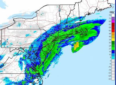
Above is a recent surface chart for the East Coast. The low center is off of Cape Hatteras and the precipitation shield has spread from North Carolina into New England. See how useful a coastal radar is, and how outrageous it has been that we haven't had one!


And here is the infrared satellite picture. You can see the hook shape associated with the circulation of the storm.


Computer models are suggesting the storm will strengthen and move northeast...here is the predicted pressure and precipitation pattern later tomorrow AM. Lots of isobars, which mean large pressure differences and wind. The winds rotate counterclockwise around the low and are roughly parallel to the lines...so very strong NE winds will hit the NY metro area and N. England. Cold air is pushing south in this flow and heavy snow and strong winds will be experienced. Often the snow is enhanced in narrow bands, the position and intensity of which are very hard to predict.

LaGuardia Airport is now stopping planes from taking off and many flights in regional airports have been closed. Winds are now gusting to 20-30 mph at many locations and it will get much worse. This is fairly early for such a major coastal snowstorm, and the season extends in March.

Northeasters, like our coastal storms (which also move to the NE), are extratropical cyclones, dependent on horizontal temperature gradients for their energy. Northeasters can derive energy from the huge temperature differences between the cold air of the interior and the warm Gulf Stream offshore. The movie, the Perfect Storm, was about a Nor'Easter, back around Halloween of 1991. If you want a laugh check out the section of that movie with the meteorologist looking at the satellite picture, shaking in expectation--"oh my God!, you can be a meteorologist for decades and now see something like this" or something like that. And then the actor points to the wrong thing on the wrong satellite picture.... Want to see a bit of this? Go to around 54 seconds and play:

http://www.youtube.com/watch?v=gVwuy-4TzU8

(sorry...viewing the wacky and wrong stuff about weathermen in movies is an evil pleasure for me)

Finally, it DOES look we will cool down midweek and there is a chance of some lowland snow showers. Right now the set-up is not ideal for anything major....so don't get too excited. Lots of snow in the mountains though...

Darkest Day and Possible Snow

| comments

This will be a blog about contradictions. Yesterday was very dark over much of the NW, in fact in Seattle it was the darkest day since January 10th of this year based on the solar radiation measurements at the UW (this fact was communicated by Mark Albright, past state climatologist). First, we start with the darkest period of the year based on the amount of solar radiation reaching the top of the atmosphere (of course, the darkest day by that aspect is December 21st). Then we add unusually thick clouds with lots of water content that scatter and absorb the radiation we do get. Between the two, not much got in. Here is the plot of observations and solar radiation at the UW for the last three days...the last line is solar radiation.....pretty pathetic yesterday!So how do we brighten things up? Snow, of course. And the latest runs are suggesting the potential for lowland snow next Wednesday. Here is the forecast for 10 AM next Wednesday: cold air in our vicinity and a low center off the SW coast of WA. This pattern, and the upper level flow associated with it, are close enough to the canonical pattern for lowland snow to be concerned. And the model explicitly is indicating snow near sea level. But I would not get too excited yet--this could change. But local municipalities should go into a watchful waiting mode, insuring that their crews are rested, the salt and deicer bins are full, and the reversible lanes of I5 are ready to go.

And I hope everyone has a relaxing holiday weekend.

Perspective on the Winter So Far

| comments

Real Northwest winter starts roughly the first week of November and roughly ends the last week of February, so we are now approximately midway. Congratulations! By real winter, I mean the period we typically get serious weather...the big windstorms, rainstorms, flooding, snow events, etc. Yes, I know...it can be cloudy and grungy into June, but if you look at any of the statistics, we rarely get the big stuff after March 1. And as I noted in an earlier blog, the peak of bad weather ON AVERAGE is behind us and ON AVERAGE we start drying out slightly in December. But beware of averages.

So midway, how has the winter panned out? Has the La Nina connection worked out the way we expected so far? The media has been talking about the "wacky" weather and California is experiencing flooding and heavy rains. Lets stand back for a second and review.

Here is the departure of precipitation from normal over the last sixty days. Green and blues are above normal. Bottom line: most of the West Coast has been wetter than normal by 2-8 inches, with the most anomalous wetness over the Sierras of California. In fact, Los Angeles is on track to have their wettest December on record. Is this pattern consistent with La Nina?...not exactly. During La Nina years the NW is usually wetter than normal and central CA is drier than normal. So, the California wetness was not expected. But keep in mind that the La Nina/El Nino correlation to West Coast weather is really only about probabilities....the wet north, dry south pattern is more probable....but other things CAN happen.

Here is the same map for departure of average temperature from normal for the same 60-day period. Temperatures generally near normal. This is what we expect for the first part of La Nina winter...the colder than normal temps generally occur after the New Year. But we have had some short periods of warmer and cooler than normal temperatures.


What about snowpack? Over Washington we are at or a bit BELOW normal right now (see map), and as you go south the snowpack is decidedly above normal..roughly 120% in Oregon and over 200% in the Sierras. California needs all the water it can get, those poor devils! Based on La Nina conditions we would expect the Northwest snowpack to zoom well above normal during the next two months....but again, this is a statistical correlation, not an exact prediction.


Next, here is a plot of temperature at Seattle Tacoma Airport since Nov 1, including the average high and low temperatures. Well above normal in early November and below normal for that week in November. Since then we have been very near normal most of the time, perhaps a bit above normal. Average the whole winter, nothing unusual! You can see how deceiving long-period averages are....we had record highs for a short while and record lows at other times and the seasonal average will be near normal.
And here is the cumulative precipitation at Sea Tac for the same period. Roughly two inches above normal. Long periods of light precipitation, with a big hit earlier in December when we had the flooding.

Has this early winter been wacky and unusual? Not particularly. Pretty much every year there are storms and floods and daily records. Sign of global warming? No reason to think so.

Finally, thanks for all your positive statements from my last blog. Most of you are wonderful and respectful, but there is a very small minority whose comments, both on this blog and in separate emails, range from the bizarre to the mildly threatening.

The Easterly Windstorm Forecast and a Clarification

| comments


First, some of you noted that you had strong winds and feel the NWS didn't give you warning. I should note that next generation model resolution--which is not available generally--might have helped. Here is output from the new 1.3 km resolution WRF model at the UW and you can compare to the 4-km, which has been around awhile. The 1.3 km is far better, with stronger winds and even got the winds hitting Bainbridge island. The NWS uses a 12km model that does not have much of Puget Sound--only at 1.3 km can we do a reasonable job. They do a good job with tools they have.

Events such as Saturday's are extremely complex, with large gradients in wind speed.


Finally, a personal note based on a few complains.

This blog IS NOT a forecast service.
I will not be blogging about every event, even major ones.
It will NOT be available all the time.
You should NOT depend on it for warnings about serious weather events.

The National Weather Service provides 24-7 service and does a very good job in general.

My goal for this blog is not to provide continuous forecasts and warnings, but to provide explanations for major weather features and as scientific outreach to the community. It is about science education. And once in while I will talk about my other interests, such as math education.

Major Easterly Wind Event

| comments

Wind damage near Enumclaw
Picture Courtesy of the Seattle Times

Strong winds over western Washington and Oregon are almost always out of the south, the product of low pressure centers moving up the coast and/or making landfall to our north. On rare occasions (like on Nov 22 with the cold outbreak), we can get fairly strong northerly winds as cold air pushes southward during an "arctic blast" situation. But there is another direction that can bring very strong winds, but only for certain foothills locations and very specific situations---easterly winds. And yesterday such an event occurred.

Winds gusted to 70-80 mph at foothills locations like Enumclaw and Black Diamond, and a swath of 50-60 mph gusts extended westward over southern King County. North Bend and Snoqualmie Summit are other windy locations. Lesser, but damaging easterly winds also occurred in parts of Seattle. Roughly 100k customers lost power in the Puget Sound region, and power outages also occurred near Portland due to flow accelerating out the Columbia Gorge.

This is probably a 2-5 year easterly wind event. Not the biggest by any means. The big kahuna event was December 24, 1983. Winds gusted to over 120 mph in Enumclaw and the damage was extraordinary--roofs off hundreds of buildings.

Easterly winds are relatively rare in our region for a few reasons...but the major one is that we have a major mountain barrier...the Cascades..that block flow from the east for most situations. However, if you look at a good terrain map of the region, it is clear that Cascades are not uniform--there is a major sea level gap in the Columbia Gorge and a weakness in the central Cascades called Stampede Gap (my book has some good topographic maps and talks about all this if you have it).

Under the right conditions air can push through Stampede Gap and accelerate as it descends into the lowlands...late Friday and Saturday were such a day. You want a large pressure difference across the Cascades, strong flow striking the Cascades from the SE, and for reasons I will explain, a wind reversal above the mountain crest and often a layer of stable air there as well.

Here is a surface chart for 4 AM on Saturday. You can why we had this event....a low center moving northward off the coast and high pressure inland. The lines are isobars....lines of equal pressure. There is a huge pressure difference across the Cascades and this configuration also produces strong SE winds at crest level.

At the height of the event there was over 10 mb of pressure difference across the Cascades (this is quite large). Research has shown that the strong winds along the eastern slopes of the Cascades are not simply winds accelerating from high to low pressure. In addition, with a wind reversal or layer of stable air above crest level, the development of a high-amplitude mountain wave adds more "juice" to these events. I don't have the space to explain this in the current blog, but think about high amplitude versions of the waves in the lee of mountain barrier that produce lenticular clouds or the water descending down a dam.

Current generation high-resolution computer models do a pretty good job with such events and the National Weather Service did an excellent job putting out a high wind warning before the event. I should note by the way, that there were also strong winds in the western Strait of Juan de Fuca and along part of the coast, and the warnings included that.

Here is a sample of a computer forecast made early Friday, verifying at 7 AM Saturday. Wind gusts are shown by the shading. You can see the strong winds in southern King County and the accelerating winds in the Strait of Juan de Fuca and the strong winds offshore.

Finally, I should note this was also a major wind event in the Gorge and winds in the Portland area accelerated to 40-50 mph. This winter is one that keeps on giving...at least meteorologically.
 
Support : Creating Website | Johny Template | Mas Template
Copyright © 2011. The Weather - All Rights Reserved
Template Created by Creating Website Published by Mas Template
Proudly powered by Blogger