
 Ever notice than when cool, cloudy conditions move into western Washington during the summer, eastern Washington weather can become very active with strong winds, wildfire blow-ups, and sometimes dust storms? Well, it happened again today!
Earlier today a weak cold front/trough moved through the area. Cool air and high pressure spread into the west side of the state, with a lot of it blocked by the Cascades. As a result a large pressure different built across the Cascades (see model forecast for 11 AM this morning).
 Air accelerated across the crest and even more so in gaps in the mountains...the most prominent of which in the central Cascades is Stampede Gap east of Snoqualmie Pass. Air accelerated into Cle Elum and further strengthened as it pushed into Ellensburg...with some with gusts reaching 50 knots (around 58 mph). Lesser winds (20-40 mph) descended some of the eastern Cascade foothills, with strong winds (15-25 mph) over substantial portions of eastern Washington. Here is 6-h forecast
of the sustained (not gusts) surface winds, valid at 11 AM.
 The strong winds unfortunately help further stoke the Swakane fire north of Wenatchee to 12000 acres (see below).
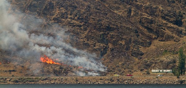 Furthermore, dust was raised elsewhere in eastern Washington, such as near Soap Lake. Take a look at the picture at the top of the blog--you can see the smoke (greyish white and the dust--light brown).
Strong winds like today are also good for the wind energy industry as long as it doesn't get TOO strong. Then they have to feather the turbine blades to reduce stress on the structure.
In any case, the winds should fade back tonight and tomorrow, which should be helpful to those trying to get the fire contained. But it should not be forgotten that sudden acceleration of winds associated with cool air moving into the west can cause eastern Washington fires to explode or move rapidly--and that is why NWS meteorologists and other professionals are assigned to all significant fires, playing crucial roles in protecting the lives of firefighters.
Finally, if any of you are interested, I will be one of the instructors this summer (August 5-8) at the North Cascade Institute's Northwest Naturalists Weekend: Weather, Wildfire and Biodiversity. I will provide a series of talks on NW weather and the other instructors will be talking about effects of wildfires and about lowland forests. Plus, hikes and canoe trips and good organic food in a beautiful location. For more information go to:
http://www.ncascades.org/programs/seminars/course.html?workshop_id=1018


