IRONY ALERT!!
Updated 2 PM, Wednesday. Guess who showed up at my office just now????...a reporter (Glenn Farley) and cameraman from KING-5 TV!!! They wanted to talk about the hot, dry summer and how unusual it was! When they closed my room's shades, turned on their blinding lights, and closed the door...well, I was a little concerned. I am afraid to see what will go on air tonight. Some sort of revenge tactic? Will they turn me into a scarester too? We'll see.

The media was up to its old tricks last night-- this time hyping the upcoming "dangerous" heat wave. All the TV stations do it, but none are better at it than KING-5. They are masters of the art. First the news anchors broach the topic, with tremulous voices asking the question--will a dangerous heat wave hit the region the next day? Then they turn to a smiling, yet serious, Jeff Renner who provides a knowing, sympathetic, nod of agreement. Last night, he had his work cut out for him, but finds the most extreme temperature maxima in the region to provide some reason for concern (last night he had to really stretch, quoting the temperature in Vancouver, WA.,which gets the Willamette Valley heat). And then they always turn to their on-scene scarester-reporter. And KING has the top weather scarester in the country...Jim Forman. I love this guy. I wish they sold tapes of his segments...I could watch it for hours. In the winter he hypes snow and in the summer heat. During the last heat wave he had a giant round thermometer stuck at 105F that he kept on flailing about. If nothing threatening is going on...no problem..he will describe the terrible events that will certainly happen to the unprepared. And he always shows people desperately buying emergency supplies in convenience stores and supermarkets. I mean...this guy has a winning formula.
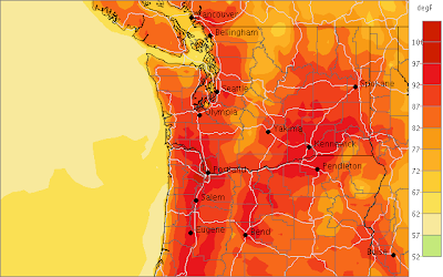
Anyway, our models are indicating a substantial warm up tomorrow...and the central and south Sound could see a few 90s....particularly away from the water. The probcast forecast system (www.probcast.com), whose strength includes these types of days is predicting 92F for Sea Tac tomorrow. (Check the graphic for max temps tomorrow).

Easterly flow will develop tonight over the region, bringing further warming to the west side (and the over us is already quite warm). As you can see from the surface weather chart (pressure and temps shown), the famous thermal trough will move into western Washington (chart) with the heat....our temperatures will spike tomorrow and then decline a bit Thursday as some marine air moves in Thursday AM and the thermal trough jumps to the east side.

7 AM update...on wed..looks more like 89-90F at Sea Tac today..warmer, but not that warmer than yesterday


