Western Snow Season Begins

| comments


 In a real sense, the winter season began today along the entire West Coast.   Nearly simultaneously, snow struck higher elevations in the Cascades (including Paradise on Mt. Rainier) and in the Sierra Mountains (Donner Pass and Squaw Valley Resort), while rain wind hit southern California (see pics below).


Paradise at Mt. Rainier
Donner Pass
Hollywood
Why such widespread winter-like conditions so early in the season?  The answer is a very high amplitude meridional (north-south) trough of low pressure along the West Coast.

Take a look at the upper-level (500 mb) chart this morning.  Pretty amazing...low heights over the Northwest and a strong trough and strong winds (indicated by the closeness of the height lines) over central and southern California.

The latest Climate Prediction Center forecast for the next two weeks is for colder than normal and wetter than normal conditions over the Northwest....and the pattern looks very similar to last year's La Nina situation.  Forget about watering your garden.

And now the bad news--the computer models are more emphatic than ever that we will have to deal with a second La Nina year...yes, a double dip.   Here is an example of a collection of various models:


Most of the them are calling for negative sea surface temperature anomalies (differences from climatology) and the Climate Prediction Center's coupled atmosphere-ocean simulation system is even more emphatic.  Although this year's La Nina is a bit weaker than last year's, examination of previous double dips indicate that the second year can have a similar impact even if weaker.  The good news....skiing should be good this year and we will have lots of water next year.

Finally, some major radar news.  The Camano Island radar is back on line after being updated to dual-polarization.   So far there is no place for you to see the new dual-pol radar products on the web.   I am hoping that we can soon put some of the them on the department web site within a few weeks.  Several of you have also asked is there a place where are the radars are combined for your viewing pleasure...there is...my department is combining the U.S. and Canadian radars and you can access these graphics here.  This interface uses google maps technology, allowing you to zoom into the area of interest.

Visibility Loss at Daybreak

| comments

A month ago, Greg Johnson of Skunk Bay Weather asked me why visibility often gets much worse after sunrise and then improves at sunset.  And several other of you have asked the same question.

Here is what Greg was talking about.  First the view at 5:32 AM on August 24th.  Great visibility and the mountain peaks are clearly evident.


A little over an hour later (6:53 AM) and the it is all murk.  No mountains!


You can watch his video of this "event" by clicking here.
Or another good example in July is found here.

Did some strange cloud come in with sunrise?  A rising of obscuring vapors forced by the sun? Camera problems?   None of these I suspect!

Let me tell you what is happening--and I have confirmed my interpretation with a department radiation expert.

Before sunrise, there are particles and droplets in the air, particularly near the surface, but they are not being illuminated by the sun.   The mountain peaks are either getting illuminated or are silhouetted by the rising sun.  Then the sun comes up and some of the light get intercepted by atmospheric particles and a portion of this light is scattered back to your eye--that produces the hazy look.   You get a lot more light from the scattered particles than distance objects, causing the objects to fade out.

This effect is worsened by being in a location with lots of moisture and particles...like the coastal location above.  And the reduction of visibility is worst near sunset since most of the scattering is in the forward direction (forward scattering).

Interestingly, away from the water, visibility often improves mid-day as drier, cleaner air gets mixed down from aloft, as the surface heats and the lower atmosphere becomes convectively mixed.  But that is for another blog.

Pledge Breaks.    Yes it is pledge break time at local public radio stations.  If you do support public radio, I recommend my new station KPLU.  I am not only impressed with their programming, but they have proven to be a real class act in all my interactions with them.

Dog Update:  My little dog is still out there...probably in the Montlake Terrace to Brier area...keep your eyes out for her if you live up there!  Thanks so much..cliff

Sometimes a forecast goes wrong..

| comments

One often learns a great deal from failures, and certainly Friday was not a great success for my profession....and it serves as a good illustration of how useful weather radar information is when the computer forecast models have problems.

The weather predictions for Friday afternoon was for relatively warm conditions  (70F for Seattle, 72 Tacoma) with only a slight chance of rain (roughly 10%). 


 The computer models did not show any rain over western Washington, such as this prediction by the NWS NAM model for the three hours ending at 2 PM:


 Or the UW WRF for the same period:

 Similar to solution to the NWS model.  And yes, my forecast for KPLU--made around 7:30 AM, and before the precipitation was obvious in the radar, was too dry and warm as well.

It became evident in the morning hours that the models were missing a major ingredient as precpitation was evident offshore and then moved in over us--thanks to the new Langley Hill radar (images at 10:30 AM and 12:03PM):

Most of this precipitation was due to mid-level instability (and convection) and very little reached the surface.  Thus in some sense the model verifications really weren't that bad...but the cloudiness resulted in the max temperature being well below the predicted and the edge taken off a supposedly nice day.  Sea Tac for example only reached 65F...5F below the forecast.

Here is a nice video showing the development of the mid-level convection:

http://www.atmos.washington.edu/~ovens/loops/flash2.cgi?/images/webcam2/movies/20110930.swf

So if one watched the radar carefully, you could have seen the forecast going wrongand alter it....we call this nowcasting.

So what went wrong?   There appear that there was a weak offshore disturbance that was poorly described in the initial state of our numerical models.  Here is the 9:30 AM infrared satellite photo that suggests such a feature:


During the next few months the NWS and the UW will be using the information from the Langley Hill radar to initialize our models, perhaps this will help improve the short-term forecasts of such events, but it will do little to help predictions more that 6 hours out.  To improve these will require better use of satellite data and more satellite data.

Note:  The Camano Island radar is down now for upgrading to dual-polarizaton...should be up by the end of the week....cliff


DOG Alert

We had a solid spotter report of my lost cockapoo in Mountlake Terrace near Terrace Creek Park...if any of you live or work up there can you keep an eye out?  For a picture of her, check the link on the right.  Thank you so much. 
http://misscockapoo.blogspot.com/2011/09/missing-black-female-cockapoo.html
Here is the area she was seen last in:
This dog was lost on 9/10 and has moved 10 miles in 19 days.  

Virgin Pacific Front

| comments

The fronts we experience in the interior of western Washington and Oregon, or east of the Cascades are generally pretty wimpy affairs, having been highly modified and weakened by the coastal mountains (including the Olympics) and then the higher Cascades.   Wind shifts are generally weak, precipitation intensity moderate, and the structures torn apart by the terrain.

But out over the Pacific, men are men, women are women, and fronts can be well-defined and far stronger.  Until the Langley Hill radar was installed, our knowledge of Pacific frontal features were mainly based on research work done by aircraft and coastal radars completed over relatively short periods during field experiments--Peter Hobb's group at the UW did the classic work on such systems.

Well now we have a wonderful operational radar looking offshore and we had a view of a beauty of a front.

Now we start with a visible satellite picture at 12:45 PM on Monday as the front approached the coast:


Nice looking frontal band, but exactly where is the front? How strong is it?   Well, we don't have to worry anymore folks...we have the Langley Hill radar.  You can see it offshore (below) --a band extending SSW to NNE crossing the NW tip of the Olympic Peninsula.  Notice the corrugations in the front?   Classic...there are cores of heavy precipitation and gaps between them.


Take a look at the observations at Destruction Island (just off the central WA coast) for the last few days--and take a special look on the 26th (times are in UTC-- 12 is 5 AM, 0 is 5 PM).  You can see the trough of low pressure with the front and winds gusting to 60 knots.


Impressive....and stronger than any of the winds that hit Long Island during Irene. 

The strength of such Pacific fronts are not uniform...they are much stronger in the core areas of heavy precipitation than the gaps in between.  Sometimes the frontal characteristics are INTENSE in the cores.  During the 90s we have field experiment called COAST in which we flew the NOAA P3 Hurricane Hunter aircraft into a Pacific front.  The scientists wanted to go out and cross one of the cores to see what it was like.  The NOAA P3 pilots agreed...they had been through many hurricanes, so they were not concerned.   Well, the passage through the core was very, very intense--with several g's up and down and even the coffee pot broke off in the rear of the aircraft.   Several scientist thought they were going to die. The pilots were shaken...no more flights through cores at low levels--this was a lot worse than going through hurricane eyewalls!

DOG Alert

We had a solid spotter report of my lost cockapoo in Mountlake Terrace near Terrace Creek Park...if any of you live or work up there can you keep an eye out?  For a picture of her, check the link on the right.  Thank you so much. 
http://misscockapoo.blogspot.com/2011/09/missing-black-female-cockapoo.html
Here is where she was seen:


Reminder:
Friday, September 30th 6-8pm
West Seattle Meet & Greet Happy Hour with Candidates Marty McLaren & Sharon Peaslee (and I will be there too!).   Refreshments, of course.
TOPIC: Improving Math, Science and STEM in SPS
7020 18th SW (north of SW Myrtle)
Donations appreciated. - all are welcome

The New Radar Documents A Frontal Passage

| comments

Monday Morning Update:

Here is the storm total precipitation ending 10:30 AM on Monday from the new radar....notice the enhanced precipitation on the windward (SW) slopes of the Olympics:


In science, major advances in understanding often come with a new instrument, one that casts light on a previously unobserved phenomena.  Certainly, that is true of meteorology; through new understanding and additional data from new sensors, the skill of prediction increases.

The frontal system that passed through during last night and today was observed from beginning to end by the new Langley Hill radar---lets take a look at only one viewpoint:  the reflectivity at the lowest elevation angle (.5 degrees).   As we have talked about many times in this blog, such reflectivity is closely related to precipitation intensity.

First, consider the image at 5:34 PM yesterday.  Note the precipitation intensity (reflectivity) is given in dbz and yellow is very heavy stuff, green a lot lighter, etc.  Looking offshore we could see the approach of the Pacific frontal system (something we could not do before).   During the day yesterday (Saturday) the skies over Puget Sound clouded up and some light showers formed as the air over the western interior destabilized at midlevels--producing lots of altocumulus castelanus.   You can see the light showers in the radar, indicated by the north-south linear features.   Not forecast well.   This was not frontal precipitation, but rather the instability was initiated by the approach of the upper level trough associated with the front.


Four hours later around 8 PM the offshore precipitation was approaching rapidly and some light showers remained over the western slopes of the Cascades,


As the evening progressed the band reached the coast, as shown by this image at 1:44 AM.  Look how nicely the radar shows the band from Vancouver Island to south of Tillamook, Oregon.  The location of this radar was chosen very, very carefully to allow such a comprehensive view.  Behind the band the precipitation is spottier and more intense, indicative of convective precipitation.

And now the great disappearing trick!  The Camano Island radar had a blind spot west and south of the Olympics.  Of course, our new radar has a blind spot too--NW of the Olympics!   Here is a view of few hours later that shows this.  Believe me, the band extended north of Everett.  And look offshore...you can see instability showers over the Pacific, with some with red colors---very, very heavy rain.  Interestingly the surface front (with the lowest pressure and windshift) was NOT with the continuous precipitation band over Puget Sound, but was still offshore at this time.

In fact, there was another band of precipitation, fairly convective looking, that come in with the front around 9 AM Sunday (see below).

 Around 12:38 PM there were lots of showers over the western slopes of the Olympics and coastal mountains.   You see the regular streakiness in the convection?  That is associated with convective roll circulations.  And see the bluish colors just off of Gray's Harbor?  That is the radar seeing the surface of the ocean.


And finally the situation after the front around 5 PM on Sunday...a few convective showers over the Pacific.  Showers and sunbreaks.

This radar is going to teach us a great deal about Northwest meteorology.  Knowledge that will both aid my colleagues in the National Weather Service and help us gain a better understanding of the interactions of incoming weather systems with our coastal terrain.

 Seattle School Board Candidate Events

There are two important gatherings to listen and talk to Seattle School Board candidates:

Wednesday, Sept 28th-7:30pm
The Stranger's School Board Candidate Debate
Town Hall - 1119 8th Avenue, Seattle
NOTE:  The event is FREE but tickets are required.
Click here for ticket information.

Friday, September 30th 6-8pm
West Seattle Meet & Greet Happy Hour with Candidates Marty McLaren & Sharon Peaslee (and I will be there too!).   Refreshments, of course.
TOPIC: Improving Math, Science and STEM in SPS
7020 18th SW (north of SW Myrtle)
Donations appreciated. - all are welcome

Sweating in the Pacific Northwest

| comments

 Note:  I made some changes to the html code that should make the blog work far better for IE9 browsers.  Let me know if anyone is having problems with performance of this blog on any browser...cliff

Bicycling to work today, I found myself wiping the sweat from my brow as I entered my building.  It really felt like the East Coast during summer out there. In fact, the last few days we have had some unusually humid air over the region, with nighttime minimum temperatures far higher than we are accustomed to.    The dewpoints were quite high this morning...rising into the mid-60s in some locations.   In fact, during the past day we have had the most humid air of the summer invading our region.  What is going on?

During the past several days we have had a pattern with unusually high pressure to our southeast and low pressure to our northwest (see graphic at roughly 18,000 ft--500 hPA pressure).   The result is a strong current in the lower to middle atmosphere from the southwest extended well back into the subtropics.  A flow that effectively transports moisture into our region.

 Here is a graphic showing the total water vapor in a column of air over the NE Pacific this morning--you see the current of high water vapor values heading our way from north of Hawaii?   This is often called an atmospheric river.

This river of moisture has been mainly directed into Vancouver Island and central BC and they have had very large amounts of rain this week.   You can also see the current of moisture--at least the part associated with clouds--in the visible satellite image this afternoon:

We have been just on the southern side of most of the clouds and rain, but within the current of higher than normal moisture.

With a current of warm, moist air coming towards us, our temps have been above normal and with the humidity our low temps have been WAY above normal.   Water vapor is very active in the infrared--in fact water vapor is the most important greenhouse gas in the atmosphere.  Such gases tend to warm us up at night--- they intercept the infrared radiation leaving the earth and reemit some back down to the surface, thus lessening cooling.  There is a reason deserts are cool at night--not much moisture.

Take a look at the temperature plot for the last week:
 See how high our minima have been the last three days? 10-15F above normal!

In short, we have been in the sweet spot--on the southern edge of a plume of warm, moist air.

Tomorrow will be the last day of the semi-tropical warmth, with temps getting into the lower 80s in places.  And the pattern shifts and we will have rain on Sunday and clouds/rain for much of the next five days.....

well...autumn did begin today.

Dog Update
   Still looking for my little cockapoo Leah.   My family is convinced that someone has picked her up in the area near the intersection of  105 N St., Holman Rd, and Greenwood Ave N.  Here is the area:

If any of you live in this area, please keep your eyes out for her (see link on right for pics). Let me know if you see anything.

 Seattle School Board Candidate Events

There are two important gatherings to listen and talk to Seattle School Board candidates:

Wednesday, Sept 28th-7:30pm
The Stranger's School Board Candidate Debate
Town Hall - 1119 8th Avenue, Seattle
NOTE:  The event is FREE but tickets are required.
Click here for ticket information.

Friday, September 30th 6-8pm
West Seattle Meet & Greet Happy Hour with Candidates Marty McLaren & Sharon Peaslee (and I will be there too!).   Refreshments, of course.
TOPIC: Improving Math, Science and STEM in SPS
7020 18th SW (north of SW Myrtle)
Donations appreciated. - all are welcome

The Big Day Arrives. The Washington Coastal Radar is Operational!

| comments

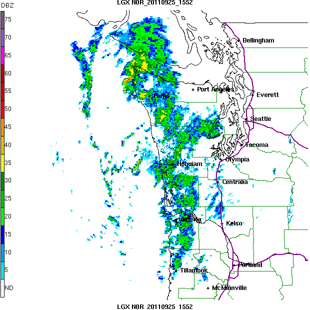
Today I received a wonderful email from Brad Colman, head of the Seattle National Weather Service Forecast Office:   the new coastal radar, located just north of Hoquiam, is now fully operational and the data is flowing to the outside world.

This radar, on top of Langley Hill, has been updated to include dual-polarization, which will allow a whole new collection of valuable products.

Enough talk, here are some examples.  Today there is a band of precipitation offshore that is slamming into Vancouver Island.   Want to see?   Check below.  Pretty impressive...and you will notice the precipitation band stretches south to offshore of northern Oregon.


 Here is what the Seattle radar shows--virtually nothing over the offshore waters south of Forks.


Here is a long range view of precipitation from the new radar.   This is amazing!  We can see another band two-thirds up Vancouver Island--some of it 400 km (250 miles) away.


All this stuff is online for your viewing pleasure (click on links)

National Weather Service site
UW Radar Site
and many others will be available soon.

For the first time, residents of the Washington coast now have what many of us have enjoyed for years---real time radar coverage.  And just as important, we can finally see the details of storms approaching our coast.   There is only one thing left to do on the radar--to turn on the zero-degree elevation angle scanning that will greatly increase its offshore range and low-level coverage.  This crucial enhancement is scheduled to be initiated during the next two months.

For more background information check out the radar website:

http://www.atmos.washington.edu/~cliff/Langleyradar.html

Microclimates

| comments

When nights are longer, winds are light, and the skies are clear we often see larger local differences of temperatures at night, and particularly at daybreak when temperatures are coldest.    Consider the temperatures around Puget Sound this morning at 7 AM (sunrise was 6:53 AM):

Click to make bigger!
Quite a range!  Temperatures varied from 37F at Shelton to 52F near the water in Seattle--15F!.   Clearly, being near the water helped keep you warm (temps of Puget Sound were in the lower 50s) and there was substantial cooling as you moved inland.  And remember these are air temperatures at roughly 5-6 feet--the temperatures of some of the ground surfaces could have been lower.   Perhaps even some frost near Shelton!

During the late fall, when the water is still near 50F and the interior drops into the teens, we can have far larger temperature differences.

But proximity to water is only one cause of temperature variations.   The urban centers tend to be warmer (the heat island effect) due to the release of heat by concrete and the multitude of heat sources in a city.

And then there are terrain effects.  Cool air tends to flow into valleys and low spots, and thus they are cooler...sometimes by 5-8 F compared to surround hills or ridges.  If you have a car thermometer you can see this effect as you drive.   Or if you are crazy like me, you might walk around a hilly neighborhood with a digital thermometer.

You see why TV weathercasters show multiple temperatures on the news--they have to---temperatures are too variable around here.

What about daytime high temperatures?  Here are the temps at 3 PM this afternoon.
click to expand
Mid-50s near the water to mid 70s inland...even as high as 81F at Kent.  Roughly 25F variation.  Temperatures of course decline if you go high enough, since in generally temperature decreases with elevation:  thus, temperatures are less in the Cascades.

You got to love living in an area whether you can choose your climate with a few mile drive. 

Of course, there are even smaller-scale microclimates:  the differences between an eastward or westward facing slope, north or south side of your home, shady versus sunny plots, and more.  I learned from experience where I should not plant my tomatoes.

Friday, September 30th, I will participate in a meet-and-greet with two excellent Seattle School board candidates: Marty McLaren and Sharon Peaslee at Puget Ridge Cohousing Assn, 7020 18th SW (north of SW Myrtle) from 6-8 p.m.  Refreshments of course.

Dog Update:  My little cockapoo is still on the loose...if you are in Seattle and see her (see below), let me know...thanks...cliff

Seattle Lags Behind In Math and This Can Be Fixed!

| comments

One of the most frustrating aspects of working on the improvement of math education is dealing with an educational establishment that makes decisions based on fads and opinions rather than empirical facts.

Now, let us accept that there are different approaches to teaching mathematics, with a major divide between the "reform, discovery approaches" and the more "traditional, direct instruction" approaches.  Reform/discovery approaches became the rage among the educational community in the 1990s and I believe it is a major, but not sole, reason that math performance has lagged.

As a scientist, it would seem to me that the next step is clear:  test a variety of curriculum approaches in the classroom, insuring the class demographics are similar, and find out what works best.  In short, do a carefully controlled experiment with proper statistics and find the truth in an empirical way.  But what frustrates me is that such experimentation is virtually never done by the educational bureaucracy.  They seem to go from fad to fad and student progress suffers.  Reform math, Integrated Math, Teach for America, Whole Language, and many more.

Last Friday I and some other interested parties met with the head of curriculum and head of science/math for the Seattle Public Schools.  I do appreciate the fact that there were willing to hear us out.  But when we asked them about what plan they had for testing various math curricula and then proceeding with the most effective approaches, you would think we were from a different planet.   No plans to do such testing and a dedication to the "system approach", which appears to be arranging lots of tutoring and alternative classes when students run into trouble.  I would suggest it is better to stop them from getting into trouble in the first place.


Just maddening!  But the interesting thing is that some unofficial experiments with the use of more traditional approaches to teaching, ones based on direct instruction, learning of foundational concepts, and practice to mastery ARE occurring and the results are stunning.

Some examples:

The Seattle Public Schools use reform/discovery math at all levels (my opinion...a disaster).  Schmitz Park Elementary got permission to  try Singapore Math textbooks in 2007 (traditional direct instruction).  Its students’ math scores soared; in 2010 the 5th graders had the third highest passing rate in the state on the state test, even though the school has no gifted magnet program.  North Beach Elementary began using Saxon Math in 2001.  Their scores rose dramatically and stayed high for years, until a new principal, who opposed Saxon, took over; then the scores plummeted.  That principal was replaced, and the scores are back up.  At Ballard High, teacher Ted Nutting's students' scores on the AP calculus test have for several years averaged far higher than those of any other school in the district--guess what he and the Ballard precalculus teacher doesn't use?  Discovery/reform math.

Or how about Seattle high schools?  Here are the scores from the Algebra I end of course (EOC) assessments in order of % of students getting free lunch (a proxy for economic status of students).   Now you might expect student scores to scale with the socioeconomic status of the students, assuming everyone got the same curricula right?  And that is generally true except for two schools: Franklin and Cleveland.  Franklin is the largest anomaly.  Well folks, a little research has found that teachers at Franklin have generally put the district-provided reform math books away and have taught the students using more traditional/direct instruction approaches...and the results are obvious.  Cleveland has double-length math classes.   Can you imagine if we had double-length math classes plus good curricula in all Seattle schools? 


What  about in other districts?  Consider Gildo Ray Elementary in Auburn, which switched to Singapore Math -- Math in Focus (traditional texts) for the last two years from Everyday Math (which Seattle uses).  The pass rates on the MSP Math Exam in 2011 for grade 5 jumped to astounding levels:

Low Income : Black : Limited English Pass Rates in the 3 Columns
47.2% : 39.3% : 23.2% : State
44.8% : 33.8% : 26.0% : Seattle
88.5% : ..n/a… : 85.0% : Gildo Rey elementary in Auburn
I could give you many more examples. But the bottom line is clear:  a large number of informal experiments have shown that direct instruction approaches with an emphasis on mastering basic facts and practice to mastery produce widely better outcomes for our students, and the educational bureaucracy doesn't seem to care.  Why?  Because the educational business is far more interested in theoretical ideas and "social justice" than empirical proof.  And Schools of Education are more a part of the problem than the solution.

It is really so sad.  Replacing the curriculum and books is relatively inexpensive and easy compared to most other changes and could be done quickly.  Don't get me wrong, poor student performance has a multiplicity of causes, from too large classes, overworked teachers, teachers without sufficient subject mastery, student poverty, lack of home support, and many more.  But curriculum improvement is a low-hanging fruit that we should grab. The money could be found for new books.  How many parents would be willing to contribute for a new textbook to insure their child had a chance for a future?  Or might the Gates Foundation contribute to textbooks instead of the valueless Teach for American boondoggle?   God knows the huge sums wasted by the Gates Foundation and Microsoft on ill-considered experiments that have generally done more harm than good.

In short, there is very strong evidence that a change of curriculum from reform/discovery/fuzzy math to direct instruction approaches with an emphasis on basic facts/mastery could greatly improve the math performance of all students.  I challenge the educational establishment to do the robust experiments that will prove or disprove this statement. Sadly, I suspect they won't.  That is why we need new school board members in Seattle and in other districts that will ask for a more rational approach to curriculum acquisition.

The End of NW Drought

| comments

The second half of summer has been really dry over the Northwest.  Take a look at the plot of actual versus normal precipitation at Spokane and Sea-Tac Airport for the last 12 weeks: we have had little rain the last month and are down 1-2 inches for the period compared to normal.  Not a serious issue since we are usually dry this time of the year.  And it is going to change!


Here is the lastest infrared satellite picture (Sat morning).  There is considerable cloudiness over us right now from a weak frontal disturbance and even some light showers are occurring), but the main action will be Sunday AM as a strong system reaches western WA. Let me remind you that the whiter the pixel in an infrared image the cooler and thus higher the clouds.


Here is the forecast 24 hr precipitation ending 5 PM on Sunday.  Pretty impressive precipitation after our drought...with .5 to 1 inches forecast over the mountains and windward slopes, and several tenths of an inch over portions of the lowlands.  Even eastern WA gets some scattered precipitation, a fact that is of importance to agricultural interests there.   Want to be dry?...go south of Portland or head to eastern Oregon.


There has been some talk about snow in the mountains, but until you are hiking about 7000 ft I don't think you have to worry about that...but it WILL be wet and windy.  In fact, the winds will also pick up noticeably over the lowlands as well.

Several of you have asked for the latest situation regarding the coastal radar.  The unit is now down for a retrofit for the new dual-polarization option--an enhancement that every NWS radar in the country will receive during the next year.  It is hoped that the radar will come back on line during the next week and the data should be flowing for public use soon after that.  A dedication is planned for later this month at the radar site.   But the radar will still be missing a critical option...the zero degree elevation angle...which will allow the radar to see much farther and better, particularly at lower levels.  Our radar will be the first in the nation to have this option and the NWS promises it will be operational by Nov 1.

Finally, any of you living in Seattle please take a look at the picture and info to the right regarding my lost dog. We took her to local dog sitter who lost the dog over NW Seattle...so keep your eyes out and let me know if you see her.  Thanks.

Reminder:  I am teaching atmospheric sciences 101--Weather--this fall at the UW if anyone is interested in taking it.  Retired folks can do it through the Access program (something like $5) and others can take the course as a non-matriculated student (but they do charge)

Resolution

| comments

 Numerical weather prediction models are generally solved on a three-dimensional grid, with the distance between the points--the grid spacing-- a measure of the resolution of the model.

We often talk about the horizontal resolution of a weather forecasting model ... the horizontal distance between the grid points.   This resolution has greatly improved over the years as greater computer power has become available--from roughly 600 km in the earlier 50s to 12 to 4 km resolution today.

Let me shown you the implications of resolution using the WRF model used at the UW.

Here is 36-km resolution--representative of the best we had roughly in the late 1990s--for surface air temperature.
Really just the major features:  no hint of valleys, Puget Sound is not apparent. No volcanic peaks.

Here is 12-km, the main resolution run by the National Weather Service today.  A bit better, with more definition.  No Puget Sound really.


 Next 4-km.  Far more structure and the valleys are much better defined.


 And finally, the best--4/3 km.  Run here at the UW  for Washington and nearby states, the detail is extraordinary.  Much of Puget Sound is defined.  Individual river drainages are clearly resolved.  You need this resolution to get realistic flow in the Columbia Gorge.


Mount Rainier and other volcanic peaks are clearly evident.  In five years or so such resolution will be operational throughout the nation.  This image is really beautiful too....you could hang it on the wall as art.

Right now the National Weather Service runs a global model at roughly 25-km resolution, and regionally at 4-km grid spacing. To be able to explicitly simulate thunderstorms one needs to do better than 4-km resolution, with more being better.

In the vertical, the resolution is dependent on the number of layers we have.   For our local WRF model we used 37, with more layers near the surface where we really need the detail.

It takes a lot more computer power to make even modest improvements in resolution--every time you double horizontal resolution you need roughly 8 times more computer power.   It is not surprising that weather forecasting uses some of the most powerful computers in the world.

Here in the Pacific Northwest we run 36, 12, 4 and 4/3 km resolution forecasts twice a day on clusters of commodity-off the shelf--processors (Intel Nehalem cores).   This activity is sponsored by the Northwest Modeling Consortium, a group of Federal, State, and Local Agencies and some private sector firms.  

 
Support : Creating Website | Johny Template | Mas Template
Copyright © 2011. The Weather - All Rights Reserved
Template Created by Creating Website Published by Mas Template
Proudly powered by Blogger