Snow, Wind, and Progess in Seattle

| comments

It is a funny thing about the weather...when things get interesting EVERYTHING seems to happen at once.  Or let me put it this way.  Sometimes there are ingredients for a major explosion laying around...the fuse, the matches, the explosives.   The question is whether they will all come together to produce the big bang.  Explosion or not, a lot is going to happen during the next few days! 

The last few days have been colder than normal (see figure) and ironically the first two weeks of November has been considerably drier than normal (by about two inches here in Seattle).  That will change.
Red lines show average high, blue lines average low
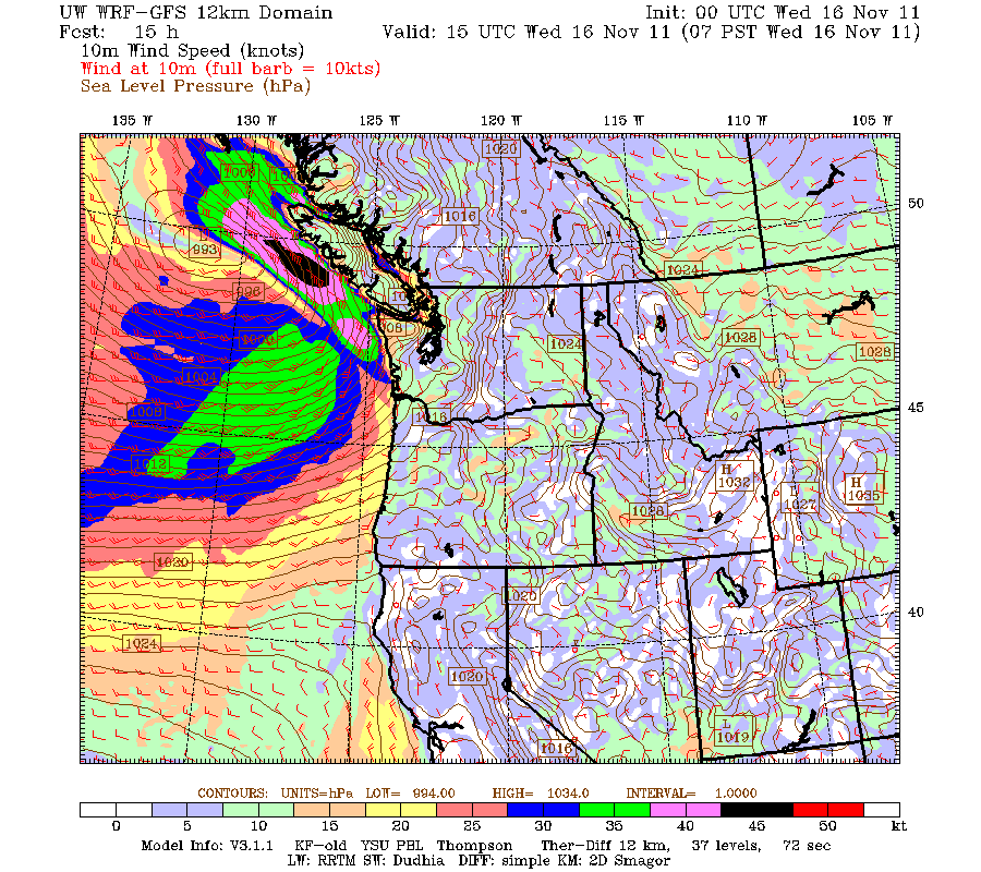
You are about to experience a weather roller coaster.  Tomorrow, a strong warm front will move up the coast (see surface chart) and before it passes powerful southeasterly winds (sustained 30-50 mph with gust far higher) will strike the Vancouver Island coast. (see wind graphic) and strong southeasterlies will strike the waterways of NW Washington (30-40 mph gusts).


This warm front and its associated low will bring heavy precipitation to the region...rain below 2000 ft and snow...lots of it.. in the mountains.  Here are the predictions for snowfall during the the next two 24h periods:


We are talking about the potential for several feet in the mountains and significant snow on the eastern slopes of the Cascades and northeast Washington (produced by easterly upslope flow as the front and low approach).  Travel in the passes could be problematic...especially the higher ones.  Prediction:  some of the ski areas will be open for Thanksgiving.

But then we get to the fun part.  The warm front moves through, followed by a cold front.  Cooler air moves in.   The low center moves southward to the southwest top of Washington and cool air is drawn in through the Fraser River Valley.  Some of it strikes the Olympics around Sequim, producing some light snow.   (see figure).


This is getting close to the western Washington snow pattern except for two important issues:  there is little or no precipitation by this point due to lack of upper level support...maybe a few showers--yes even snow showers.  And the air is not quite cold enough to guarantee snow.   But remember what I said about explosives....a lot of the ingredients are in the vicinity, if the evolution is a bit different than well...it could get interesting.

Seattle School Board Victories

   The Seattle School board race faced incumbents, who supported very poor math textbooks and who were extraordinarily uncurious about the illicit and wasteful activities in the district, against some excellent challengers.  Two days ago, one of the challengers--Marty McLaren--was declared the victor by her opponent.  Today, Sharon Peaslee moved ahead of incumbent Peter Maier and it is clear that she will win.  This is an extraordinary victory for Seattle's kids and the city in general.  A game changer.  Both Sharon and Marty support world-class math instruction that will allow our kids to be competitive with student in Singapore, Finland, and other top education countries.  They both prize the opinion of parents and the community--opinions the incumbents have ignored.  Sharon and Marty are not in "blame the teacher" mode that is so popular among the incumbents and their monied allies from the eastside.  They will ask questions and will want to take a careful look at the "books". These new school board members, plus continuing members that have shown a willingness to listen to the community, can promote a new direction for Seattle Schools, and I trust a quick exit for the current mediocre Acting Superintendent Susan Enfield, who has made one serious error after another.   The Seattle Times has played a very negative role in this race--supporting the incumbents because they were "professional" and because they knew where the problems were (since they caused them!).  The ST even had an editorial complaining when one of the challengers won and blamed it on "the unions."  and crowed that Peter Maier handily beat his challenger.   I have been embarrassed for the ST and hope they rethink their shallow and uninformed editorial approach to the Seattle Schools--the community deserves better, much better.

PS:  It is fascinating the difference between the early and later voters in this race.  Later voters broke overwhelming for the challengers.  Why?   The last few weeks brought headline and headline describing illegal and ill-considered actions in the district.  The challengers worked very hard to get their message across.  And perhaps the early voters were retired or disengaged folks that follow the recommendations of the ST (a bad idea!), while many of the later voters were busy parents who knew what REALLY was happening in the district.

Sharon Peaslee
Marty McLaren

High Winds Hit the Eastern Cascade Slopes

| comments

The big weather action today was on the eastern slopes of the Cascades, where winds were gusting nearly to 100 mph at some locations-- 96 mph at Mission Ridge.  Here are the winds at 7 pm and 7 AM, with the red numbers giving you the gusts:

7 AM
7 PM

The winds were very variable and intermittent...some places got hit by strong gusts for a while and later experienced light winds.  Here are the winds today at a high (6730 ft) east-slope location--Mission Ridge:

Some mighty good windchill up there! In contrast, winds at Ellensburg were only gusting into the 30s (knots)

Now to understand these winds one must begin by noting we have had a VERY powerful jetstream over the Pacific that has headed right into us from the northwest.
Here is the upper level chart at 300 hPa (around 31,000 ft) at 4 PM Sunday..   Some winds are well over 150 knots, with some reaching 190 kt (219 mph!!).  Don't try to fly to Asia...it will take forever.
Winds indicate by dashed lines and barbs.
These strong winds have interacted with the Cascades.  First, air approaching the mountains rise, cool, becomes more dense and causes a windward high pressure area.  As air descends, it warms, becomes less dense and produces a lee trough.   Air accelerates as it goes from high to low pressure.  And such a pressure distribution was evident across the Cascades today (see map below at 10 AM).  Here is the proof.

And the interaction of the strong flow with the mountains can produce mountain waves that can bring down the momentum from aloft and enhance wind speed.   Here is an east-west vertical cross section across the Cascade today and you can see this effect (shading indicates wind speeds--dark red is strong, and air flow tends to follow the solid lines):

Lets take a look at the wind gust prediction at the surface (really 10 meters) from the high resolution WRF model today at 4 PM.  The first is from the 4-km grid spacing domain and the second is from our ultra-resolution 4/3 km domain.  Lots of gusts over 50 kts in the high-resolution domain.


 Hate to say it...but there will be plenty more of this over the next few days.

The Weather Takes Its Gloves Off--Strong Winds and Mountain Snow

| comments

Missing Dog Update:  My dog Leah was seen near the Moose Casino in Mountlake Terrace--66th Ave W and 220th St SW.  If anyone is in the area and sees here, let us know right away! (see link on right)

We are now going into a very different, and much more active, weather period--and it starts today!

A strong front is now approaching the Washington coast and it will result in VERY strong winds in the Strait of Juan de Fuca, possible damage (power outages, localized flooding on Whidbey Island), blustery conditions and rain elsewhere, and snow in the mountains.  And I don't even want to tell you what the models are suggesting for next weekend. 

Perhaps the most profound weather phenomenon today is one I am actively researching:  a powerful westerly wind surge in the Strait of Juan de Fuca.

 Under the proper conditions, strong westerly winds can surge eastward into the Strait, reaching speeds of 50- 80 mph.  Sometimes called Westerly Strait Surges,  one will occur today.   A particular strong surge destroyed Ivar's Mukilteo Landing restaurant in 2003 (now rebuilt and my favorite restaurant) and another heavily damaged the Washington Ferry Elwha when it was under repair in Everett Harbor (December 1990).  Some pics of the damaged and rebuilt Ivars, which now has a weather theme:


The situation associated with westerly straight surges will occur today:  a broad ridge over the eastern Pacific, northwesterly uper-level flow over western Washington, and a sharp trough pushing into our region in this flow.   Here is the situation predicted for this afternoon at 500 hPa--about 18,000 ft above the surface:


You can see the strong trough embedded in intense northwesterly flow (remember the flow is parallel to the height lines and close spacing means strong winds).  As the trough passes through the winds aloft are aligned with the Strait....here are the height lines at 850 hPa (around 5000 ft) to illustrate:
You see how the height lines, and thus winds, are parallel to the Strait?  And the strong gradient of the height lines (thus strong winds) are clear.  At the surface, the front is associated with a trough of low pressure, so as it passes eastward an intense low level pressure difference (high to the west, low to the east) develops and air likes to accelerate from high to low pressure. Here is the sea level pressure forecast for this afternoon at 4 PM. Pressure is increasing rapidly up the Strait.


Strong northwesterly winds aloft and big pressure difference down the Strait both support strong westerly winds that can slam in the eastern Strait, with Whidbey Island, Everett, and vicinity taking the brunt of it.  Winds can gust to 40-80 mph.   This one is not completely ideal....so I would not look beyond 60 mph today.  Here are the WRF model forecasts for this afternoon at 1 PM.  Strong sustained winds of 35 knots have pushed into the Strait (and gusts would be stronger).
Three hours later, strong winds have reached Whidbey Island and the eastern Strait (Port Townsend and the NE tip of the Olympic Peninsula should get a taste of this as well).


The freezing and snow levels should drop as cold air behind the front floods the region.  With the flow directed up the mountains, enhanced precipitation in the form of snow should hit the mountains at and above pass level (more at the higher passes of course).  Here is the forecast 24-h snowfall  ending 4 AM on Saturday.  The model suggests a foot in the northern Cascades dropping to an inch perhaps at Snoqualmie.

Then another system comes in on Saturday with more rain in the lowlands and snow in the Cascades.  Here is the snowfall for the next 24-h--even more!
Good news for skiers!...we are going to start building the base they long for.  Skiing by Thanksgiving may well be in sight.

And now let me tell you something that I shouldn't.   The last few model cycles are suggesting a turn to colder temperatures on Thursday and the potential for lowland snow late Thursday or Friday.  Too early to be sure at this point...so don't get too excited yet.  I went to a meeting run by Seattle DOT this week on winter weather response...these folks are really girding up for battle.  And this year they will have the new UW snow-weather application: SNOWWATCH...which I will describe this week.

Bering Superstorm

| comments

An extraordinarily intense storm is now churning through the Bering Sea.

The central pressure is roughly 945 hPa--similar to a category three hurricane, and in fact this storm does have hurricane-force winds.  (a hPa is the same as a millibar, mb, which you may be more familiar with.  In the inches of mercury units this would be 27.9 inches).  Take a look at a recent National Weather Surface surface analysis (for 4 PM Tuesday).  943 hPa low center and the NWS folks note the hurricane-force winds (sustained winds of 64 kt or more).  That is a lot of isobars, with extraordinary pressure gradients.

It is quite unusual to have a storm this strong so far north.   This storm developed very rapidly--approximately 60 hPa in 48 h, thus putting it in the category of explosive deepeners or "meteorological bombs" as known in the weather literature. Here is an image of the storm from of the polar orbiter weather satellites...the low center is in the middle of the swirl.

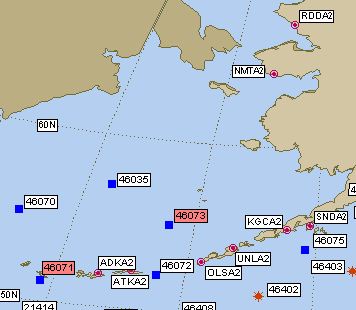
This storm is far deeper and stronger than the famous "Perfect Storm" of movie fame--at its most intense that low only got down to 972 hPa...nearly 30 hPa higher pressure.  The has passed near a few weather buoys.  Here are a few samples. Buoy 46070, found in the western Bering (see map) had a minimum pressure  of 28.2 inches of Hg (954 hPa) and gust to nearly 60 kts.


 Or Buoy 46035 (to the east) with gusts to 75 knots!


Wave heights at these locations climbed above 35 ft:


The fact that the storm is moving so quickly is preventing the waves from getting catastrophic since big waves requires strong winds, large fetch, and duration to build. Coastal flooding (up to 10 feet storm surge) and blizzard conditions add to the mix.  In any case, this will be one of the great storms of the year.

Selected Peak Gusts from the NWS Hydrometeorological Prediction Center

.SELECTED PEAK WIND GUSTS IN MILES PER HOUR 

...ALASKA...
TIN CITY AFS (AWOS) 85
WALES 84
CAPE LISBURNE(AWOS) 75
KOTZEBUE/RALPH WIEN (ASOS) 73
KIVALINA ARPT 71
POINT HOPE (AWOS) 69
CAPE ROMANZOFF (AWOS) 60
ST MICHAEL 58
TELLER 58
EMMONAK 56
NOME (ASOS) 55
BETHEL AIRPORT (ASOS) 54
SAVOONGA AIRPORT 54

Boring with a Hint of La Nina

| comments

Sometimes the early part of  November is the quiet before the storm;  this has been true for the last few days and will continue for the remainder of the week.  But don't forget:  the last week of November on average brings the stormiest, wettest, meanest weather to the region.  Meteorological ground zero for the Northwest.  Turkey on the barbecue.  And sometimes lowland snow--like November 22nd of last year.

Just to show you what I mean by boring, here is the National Weather Service forecast for this week:
Some clouds, some sun, a few light showers, temps reaching the 50s and dropping into the mid to lower 40s.  Enough to drive a meteorologist mad.

But there are some interesting aspects of the atmospheric situation of the next few days, some indicative of our old friend-La Nina.  Take a look at the 500 hPa upper level chart for Tuesday at 1 PM. A ridge over us (thus dry) and a high amplitude trough digging south from Alaska.

No umbrellas needed here.   During the next few days an amazing thing happens.  The trough deepens into a closed low off of California and becomes isolated from the jet stream to the north over the north Pacific and southern Canada. (remember the air flows parallel to the lines and is stronger where the lines are closer together).

There is a fancy name for this situation--a cut-off low:  the low is cut-off from the jet stream.   We are left in the dead zone...not much flow, not much action.  And you will notice a BIG ridge (High) over the central Pacific--we will get back to that. Here is the precipitation over the West Coast for the next 72h.  The action is pretty much all offshore.
But then things change a bit for Friday.   The ridge builds offshore  and the Northwest is in northwesterly flow (see below).  A weak trough is embedded in this flow..which should bring some clouds and perhaps some light rain. Not too scary, but this pattern is reminiscent of a La Nina configuration, like last year when we were stuck in cold, northwesterly flow for months.  If a trough develops with more amplitude and the ridge extends more into AK, we approach the canonical snow pattern.

On on Saturday...more of the same, but a bit stronger (see below).  Expect a low snow level and decent snows in the mountain.  The Mayor and SDOT don't have to worry...yet.

Don't forget to vote tomorrow...

The Great Raindrop Deception

| comments

You have been deceived...by magazines, newspapers, the digital media, by artists, school teachers, and yes, even children's books.  And it will stop here.

When raindrops are drawn, they almost always look the same way, as a teardrop.  Some samples:


The problems is that raindrops virtually NEVER look like this!  Northwesterns like us, with our persistent wet weather, should be expected to be fully educated in raindrop-ology, and thus this blog may serve as an important public service.  Perhaps the Mayor will establish a raindrop education day this year.

Well, if raindrops never look like teardrops, what DO they look like?  Well, it turns out that their shape depends on their size, a situation also obvious in humans.  Small droplets are spherical, bigger ones like pancakes, and very large ones like parachutes.   His is a graphical rendition:

Drizzle droplets (a Northwest favorite), with sizes of roughly  .3 to .5 millimeter (mm), up to small raindrops, of approximately 1-1.5 mm, look pretty spherical. (For the metrically challenged... 1 mm is about .04 inches)

Why spherical?  Surface tension--the attraction of water molecules to each other--pull the molecules together into a ball.  Furthermore, small droplets don't weight that much and their fall velocity (also known as the terminal velocity) is relatively small, so the disturbing influence of the air moving around the droplets is minimal.  I bet you have all noticed the difference in fall velocity of various size raindrops:  drizzle drops seem to slowly drift down while big rains come down REAL fast.

For bigger droplets (2-3 mm), their weight causes them to fall faster, and the greater speed of the air passing around them causes them to be distorted into a pancake shape, with a nice little dimple in the middle.

For really big droplets, the distortion caused by the fast moving air is huge...the droplets get hollowed out into a parachute-like shape.

There is a limit to how big a raindrop can get because eventually the aerodynamics forces of the passing air tears it apart.   What is the biggest raindrop ever observed?   Well my University of Washington colleagues (Dr. Peter Hobbs and Art Rangno) may have seen the largest---8.8 mm (.35 inches!!)--in tropical cumulus.   Imagine being hit by such a giant raindrops!

One final thing--our newly upgraded weather radars, with their fancy dual-polarization, have the capability to measure the shape of precipitation, including raindrops. Here is an example--the zdr product (stands for differential reflectivity).   Zdr measures the difference in return between an up-down and side to side view of precipitation, thus giving information on the shape.  When the returns in both directions are roughly the same (the difference between them being nearly zero), this product gives a value near zero. If the precipitation gets distorted, the number increases.  Pretty neat stuff--measuring raindrop shape remotely.  Looking at the image below, you can see a lot of near zero (blue) colors....not many teardrops here! The area of large values (white/gray colors) near Hoquiam is not meteorological--its ground clutter, where the radar beam is hitting the surface.
Zdr from the new NWS Langley Hill Doppler Radar

Finally, for those voters in Seattle, please keep in mind the Seattle School Board race and necessity to replace the current board members with those committed to better math education in our schools.  The math textbooks used in Seattle are terrible at all levels and I see the impact on Seattle students coming to the UW--many of them have very weak math skills.  We can do much better, this requires school board members that are willing to deal with the issue--the incumbents are not.  The challengers (Peaslee, McLaren, Martin, Buetow) are all committed to dealing with the problem. The latest school board poll is here.

Mamma Mia! That's a Nice Front!

| comments

Some nights are better than other for weather lovers, and tonight was a good one, with the strongest front of the fall moving through the region.

The new Langley Hill radar made it very clear that the approaching front was worth of some respect, with an extensive area of moderate and heavy rain. In the old days, we really would not have known this.

And we could savor the front as it made landfall and moved across the western lowlands.

Precipitation totals over the central and southern Sound were quite respectable, as shown the Seattle Rainwatch: .25-1 inch in many locations. Mayor McGinn introduced Rainwatch this week and it sent out warnings before the event.
Seattle Rainwatch 24-h totals ending around 9 PM Wed.
And the winds.... on the coast and over the eastern Strait, the winds gusted to 40-55 mph, while here in the lowlands, winds hit 30-35 mph, particularly over the water.   Here is a plot of the wind gusts at Destruction Is, off the central WA coast---gust to 49 knots....56 mph.  More than many folks saw for "Hurricane" Irene in NY and New England..


The strong, turbulent winds picked up the prodigiously falling leaves to create quite a spectacular scene in my neighborhood.  Driving rain, gusting, roaring winds, a torrent of leaves--folks, it doesn't get better than this.   And to frost the cake, during the next few hours light snow will fall in the mountains above roughly 3000 ft.

Northwest storm season has begun.

Finally, here is a marvelous video of today's show, starting with dense fog this morning that surges in and out, then clearing skies, followed by lowering cloud decks from the approaching front, and then heavy rain. Watch the speed of the clouds...the atmosphere goes into warp drive later in the day:

http://www.atmos.washington.edu/images/webcam0/movies/20111102.mov


If you are a Seattle resident and would like to participate in a poll on the Seattle School Board race, click here: http://www.easypolls.net/poll.html?p=4eb22007011eb0e4496235ab

Thursday Update: Snow in the Passes

No skiing....yet.

 
Support : Creating Website | Johny Template | Mas Template
Copyright © 2011. The Weather - All Rights Reserved
Template Created by Creating Website Published by Mas Template
Proudly powered by Blogger