Even Stronger

| comments


The latest satellite pictures shows a profound enhancement of the high clouds around this system (see above). The latest forecast models are even more threatening that last night...this is going to be a major coastal wind event, with damage and power outages. NW Washington will be hit harder than expected last night. And another issue...when the low is offshore, winds will accelerate to the west in the Strait of Juan de Fuca.
The National Weather Service has now put storm warnings for the entire coast and the western Strait of Juan de Fuca.

Here is the latest forecast for 5 PM tonight...pretty amazing. 989 mb low and a huge pressure gradient to its south and southeast. The simulation indicates even stronger winds than last night, with areas immediately offshore experiencing 60 kt sustained winds and hurricane-force gusts.

Unfortunately, most of the offshore weather buoys are broken (this is really a problem!)--that is why we need coastal weather radars! The best buoy (46089) we have now is about 90 miles west of Tillamook, Oregon and the winds there are speeding up fast (30 kts last hour).

A Serious Storm

| comments

Long Beach will be vulnerable to this event

The models are all on the same page now, confirming that the Northwest...and particularly our coastal regions...will be dealing with a serious storm event. There are some unusual aspects of this storm I want to talk about and some misconceptions that need to be cleared up.

First, a storm this powerful in middle May is quite unusual, but not unprecedented.

Second, although the central pressure of this storm will be modest by winter standards (the current forecast is for around 992 mb), the differences in pressure that drive the winds will be first class. The reason? The environmental pressure...the pressure in the neighborhood... is relatively high (partially because of the season) and thus the difference of pressure between the low and its environment will be very large.

Bottom line: this storm has big coastal wind potential. (If you want to learn more about pressure gradients and winds, check the windstorm chapter of my NW weather book) It will not be the equal of the mega events (Dec 3-4, 2007, Inauguration Day Storm), but will be one of the strongest storms this year.

Third, the path of this storm is not right for a major windstorm over Puget Sound. To do so, the low would have to cross between the middle of Vancouver Island and the NE Olympic Peninsula. This low is too far offshore. But the zone of very large pressure gradient--located south of the low center-- will swing up along the Oregon and Washington coastlines, producing powerful winds. As I will show below, the strongest winds will hit the northern Oregon and southern Washington coastal zone. We are talking sustained winds of 35-60 kts, with gusts that could reach 70-80 kts. I would not be fishing out there tomorrow afternoon and evening, and I would not be surprised if some power outages occur along the coast. The NW interior of Washington (Whidbey, San Juans) will also be hit by strong winds...but nothing like the coast.
Finally, the fact that leaves are on the trees will make them more vulnerable to wind damage.

It would be great time to head to coast to experience some real weather.

So let me show you the latest forecast output.

To start, here are the pressure forecasts from the UW WRF forecast model for 5 PM and 11 PM tomorrow (Wed) night. Very large pressure gradient along the southern flank of the storm, with the gradient concentrated in what we call the bent-back trough (a.k.a., the poisonous tale of the bent-back occlusion). The pressure gradient is largest over the offshore waters and sweeps northward along the Oregon and Washington coasts. The Puget Sound interior will get a piece of the action, but a small one (perhaps sustained winds of 20-30 kts). Coastal winds will start as southerlies and southeasterlies and then swing to westerly as the low moves northward. An associated front will move inland late in the afternoon, bringing moderate rain and colder air behind. (I won't even go into the rain and snow aspects).

Next the wind speed graphics at the same time. Impressive for a late season storm. Blacks are sustained 45 knot winds..with higher gusts. The Long Beach Peninsula is going to get nailed. I really hope that one of the TV stations sends one of their teams there. As the low moves northward the strong winds will follow (see second image)

Here is a close-up view of the winds over western Washington. As the low moves northward, winds in Georgia Strait will become strong, with sustained winds of 30-40 knots in some places. Residents of the San Juans and northern Whidbey Island should be ready for a modest blow.


Finally, there is something really weird about this storm in the satellite imagery. You can see the storm in the visible imagery (below), but it is completely unimpressive in the infrared (image). I can't remember seeing such a potentially strong storm have such a modest satellite imagery. Are we missing something? A reflection of the season?

Visible

Infrared

Storm Update

| comments

The new run is in and the forecast is basically the same as this morning. Thus, it is looking increasingly likely that a good windstorm is coming to the coast and NW Washington-an unusually strong one for this time of the year.

Here is the latest forecast from the UW high-resolution forecasting system for 8 PM Wednesday. An intense pressure gradient is evident from SE to SW of the low center. The coast will get hit hard.


How hard? Here are the surface winds for Wednesday afternoon and evening. Pink color is SUSTAINED 40 kt winds! In the afternoon, there are blacks offshore-- 45 kt sustained! And the gusts could be much greater (55-65 kts).


Away from the coast, strong SE winds will buffet NW Washington...here are some graphics for you to view for 8 and 11 PM on Wednesday night. 30-40 kt sustained winds near the water. Plus higher gusts.


Now, nothing is certain and we need to watch tomorrow's model runs, but at this time it really looks like a strong blow on the coast and NW Washington. And there will be substantial rain with the associated frontal system. Good for the plants. Hopefully my tomatoes will survive--I planted them last weekend.

Major Coastal Blow Possible On Wednesday

| comments

I will update this more tonight...but an unusually strong low pressure system...and strong winds...will reach our coast on Wednesday. Also strong SE winds over NW Washington. See pressure forecast below for 5 PM on Wednesday. More tonight. The models are still shifting the low position, so there is some uncertainty in this forecast. But if you are on the coast, planning an offshore fishing trip, or living in the region from northern Whidbey Island to the San Juans...keep tuned. And it will be windy over the rest of western Washington.

A lot of isobars!

Here is a wind speed map for 8 PM on Wednesday...sustained winds of roughly 45 kts on the coast, which would mean gusts to 60 or more. Each run has brought the low farther south--which is more threatening. Will see what tonight's forecast indicates.


There is a bird in my radar!

| comments

During the past few weeks, several of you have asked essentially the same question:

" It's been completely dry but the weather radar last night showed lots of echos, suggesting it rained all night. What is going on ?"

Well, I can give the you the answer: Birds!

Weather radar can see more than raindrops. It can see the mountains, but that signal is generally removed successfully (terrain clutter) since the mountains generally don't move. Weather radar can see other objects in the air and the amount of return generally increases by the sixth power of the object's diameter. (Doubling the size of an object increases the amount of the radar signal scattered back increases by 64 times). Since a bird is much bigger than a raindrop, you can imagine that it would provide a good return.

Another point. The weather radar used by the National Weather Service has two modes: clear-air and precipitation. Clear air mode is much more sensitive and is used when it is not precipitating to get some information on the winds. In this mode, discontinuities in the atmosphere (e.g., where density changes rapidly) and bugs (which get blown about by the wind) can show on the radar (within tens of km of the radar site) to provide some useful information.

But now we get to the birds. During dry periods the radar is on the hypersensitive clear air mode and during the night (particularly during migration periods in spring and fall) a whole lot of birds are up there. According to my birder friends and a few articles I have read on the subject, a number of birds (like songbirds) like to migrate at night, typically flying into the bottom 10,000 feet of the atmosphere. This time of the year they are flying north and in the autumn to the south. The amazing thing is this migration is really tied to the clock...after sunset, the radar is filled with echo, remains all night, and like magic disappears after sunrise. (Keep these numbers in mind: on May 15th, sunset was at 8:40 PM (3:40 UTC/GMT), sunrise was at 5:32 AM (12:32 UTC).

OK, you want to see if for yourself? Here is the radar (Camano Island) at 8:57 PM on May 14th, right after sunset. Not much echo, just ground clutter from terrain and some close in returns near the radar.


Here is the radar image less than an hour later, when it is starting to get dark 9:36 PM). Echo is starting to fill the domain. And it is NOT raining.

And here is the situation at 11:04 PM. Much of the domain visible by the radar has echo. The birds are everywhere!


At 5:06 AM the next day, there is lots of echo still:

But at 6:04 AM (remember sunrise was at 5:32 AM), the echo (and the birds) are mostly gone!


And at 8:02 AM, much less still:


Now want to see something neat? The NWS radar is a Doppler radar and thus can measure the speed of the targets towards or away from the radar. We can check out the velocities of the birds! Here is is:

Greens indicate velocities toward the radar (in knots) and yellows/oranges away. The radar location is in the middle. The birds are migrating north, roughly at 20 kts! (a relief...it would have been a problem if it had been the other way).

Ornithologists know about the value of the weather radar and use this technology to track migrations. Occasionally, there are weekend weather people on TV that make the mistake of misidentifying birds for precipitation...but you won't.

The Secrets of Staying Dry While Biking

| comments


May is national bike to work month and next week is bike to work week. Here in Seattle a big concern is staying dry while bike commuting or during recreational runs.

Now there are two ways to stay dry while biking. The first is shown in the image above--mounting an umbrella on your bike. Perhaps this would work if you went REALLY slowly and there was little wind, but for most of us another solution is needed...and I can offer it. Use the weather radar!

I commute by bike every day roughly five miles each way. Ever since a weather radar was installed in western Washington (early 1990s), I rarely get seriously wet. I mean...this has really changed my life.

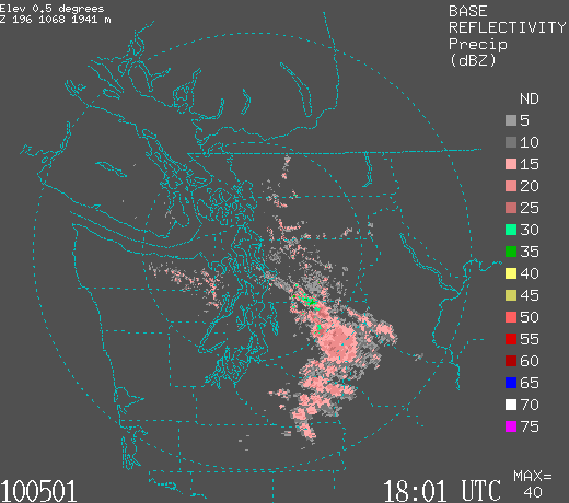
You all have seen weather radar images on TV or the web (see one below).


Weather radar basically shows you where it is raining. The units shown on the image are actually something called reflectivity, the amount of the radar signal scattered back to the radar. The higher the reflectivity, generally the heavier the rain. A rough scaling is 5-10 (gray above) for very, very light rain (drizzle), pinks (15-25) for light rain, greens (30-35) for moderate rain, yellows for heavy rain (40-45), and you don't want to know about the reds and blues. I will bike in greys and pinks, particularly if I am wearing a Gortex (or similar type of material) jacket. I avoid greens and will take the bus with yellow and reds. The National Weather Service radars provide a new image every 6 minutes. And you can view both single time and animated radar imagery on the web, using a smart phone app, on an internet-equipped cell phone, or on tv.

Here is an example of a radar animation:

http://www.atmos.washington.edu/~ovens/loops/wxloop.cgi?atx_bref1_archive+start+2007022603+end+2007022612+interval+

An interesting and critical fact about rain is that it is rarely uniform. There are heavy areas and light areas and breaks. By viewing radar animations you can spot the light areas, or make a good estimate when one will be at your location. So if you have some flexibility of when you bike, delaying or advancing your trip by a 10-15 minutes, you can nearly always avoid the real heavy stuff or secure a dry ride even on a supposedly rainy day. The more flexibility you have the better your chance of staying dry.

And radar helps in another way. If you are just looking for recreation, the radar can tell you where it is dry now and will continue to be dry for a while.

Trust me....using weather radar can revolutionize your biking life.

So where do you go to get this information? Lots of web sites offer great radar access.
Some examples for Seattle and vicinity:

Seattle NWS office site:
http://radar.weather.gov/radar.php?rid=atx&product=N0R&overlay=11101111&loop=no

The UW: (click on radar loops)
http://www.atmos.washington.edu/~ovens/loops/

All the major TV stations in town have radar links. And many more.

For those in Seattle I will be giving a talk on this topic:

"You Can Avoid the Rain! Weather Tips for Biking" on May 20th,12:00pm-1:00pm,Gerberding Hall room 142, on the UW campus

Happy biking.

Educational Disaster In Issaquah

| comments


Normally, I talk about weather disasters, but this time I have an educational disaster: Math Education in Issaquah, Washington

Issaquah, Washington is a wealthy, upscale area, with many employed at the high-tech industries of the East Side, like Microsoft and hundreds of biotech and software firms. Y ou would expect that the local school district would provide an education that would allow its students to be prepared for the technological society of the future. But the reality is that Issaquah has adopted very poor math textbooks and curriculum at all levels.
Consider the recent vote by the Issaquah School Board to adopt the Discovering Math series by Key Curriculum Press for its high schools. These books were found mathematically unsound by the Washington State Board of Education review team comprised of nationally known mathematicians. The Discovering Math series follows the failed discovery approach to learning in which students are supposed to discover principles on their own, group learning is pushed, direct instruction is not stressed, and students do not practice what they learn to mastery. Discovery math is in vogue in education schools and among their graduates in administration and the class room. (Some day I need to blog about the failures of American education schools, but I will leave that for now). The Washington Superintendent of Public Instruction's recommendation for high school math was Holt, based on the inferior rankings of Discovering.
But it gets worse than that. Bellevue Schools tested Discovering Math and Holt and found that the performance of classes using Discovering was inferior (similar demographics too!). Bellevue has wisely adopted Holt. Issaquah gave parents no voice in the selection process, with only teachers, and mainly young ones at that, having a place on the adoption committee. Strangely, the adoption committee originally voted 8 to 6 for Holt but then mysteriously switched to 14-0 for Discovering, with no information in their minutes of why the shift occurred. At a School Board meeting it was revealed that the rubric created to evaluate the two curricula was not even filled in. The whole business smells bad.

A major issue during this adoption was the activism for Discovering of the local Superintendent of the Issaquah School District, Steve Rasmussen, who clearly had an agenda to push Discovering--see his letter to the community before the vote-http://www.issaquah.wednet.edu/documents/math/HSmath/communitymath.pdf). This letter is full of incorrect information.
So you had a school administration that was pushing discovery math, parents that were marginalized and pushed to the side, and a process that was like an unstoppable express train. And the kids are the ones that will pay for this--another generation of Issaquah students will be lost to an inferior education. Issaquah parents should be furious with this adoption--perhaps if enough complain the ordered books can be returned. A group of parents considered filing a lawsuit, but felt so intimidated that they held off (which says something in itself).
And if you think things couldn't be worse in Issaquah consider the math curriculum used in middle and elementary schools:
Everyday Math for elementary, one of the worst discovering math curriculum for K-5, and CMP2, a very weak discovering math curriculum for middle school.
There is an extensive literature on the failures of the above curricula. Check out http://nychold.com/em.html for a large collection dealing with Everyday Math.

Math tutoring is a major growth industry in Issaquah, take a look at the many private tutoring offices near downtown Issaquah alone!
Math tutoring is a major growth industry in Issaquah
(locations near downtown Issaquah shown above)


Anyway, it is hard to believe that such an educational disaster can occur in such a well-heeled district with highly educated parents, but that is the unfortunate situation. There is a reason that foreign engineers and scientists are filling the ranks of American high-tech companies and universities: districts like Issaquah are insuring that their children will be unprepared for the future.

Other districts, like Bellevue, Shoreline, and Lake Washington, have or will make the switch to quality math programs, making the stance of Issaquah schools perplexing and disturbing. If you are an Issaquah parent, please complain to your school board members and the administration. Contact the media. Only if the parents put enormous pressure will the district reconsider. And, of course, there is the legal route.

Mountain Convection and A Strange Whirlwind

| comments


During the past few days we have had marvelous, and sometimes impressive, convection over our mountains (as seen in the picture above from Dale Ireland's webcam). The mornings have started out clear or close to it and then by mid-morning puffy white cumulus clouds formed over the Olympics and Cascades. By early afternoon some have grown into towering cumulus congestus and finally into fully formed cumulonimbus with showers and even some lightning.

Dale Ireland has a wonderful high definition web cam aimed at the western Olympics and here is the daily animation for Friday (http://www.drdale.com/lapse/lapse100507.mov).

Take a look at the visible satellite mixture for Friday morning and then at 5 PM. It is not hard to see the building convection from space (35,000 km above the planet!). The convection on Friday was most intense over the western Cascade slopes and the cool down rush of air from the storms pushed westward towards the lowlands, spawning some modest convection at its leading edge.


So why did we see this convection? Convection is the result of vertical instability of the atmosphere-- under the right conditions, when air given a push upwards, it keeps on going for while. Buoyant plumes of air, warmer than their surroundings, move upwards to 10, 20, or even 30 thousand feet in some locations. The atmosphere was close but not quite unstable throughout the region, but over the mountains the instability could be released.

Why is that?

As mountains are heated by the sun, air moves up their slopes and converges near the mountain crests. The two upward air stream create a strong upward current, which can give air parcel enough of a kick upwards to make the air parcel lift enough to become saturated and for instability to be released (I am skipping the details here, but you get the idea...upward motions on the mountains helps cause cumulus to form).

Anyway, things will calm down tomorrow...a perfect Mother's Day..highs in the mid 60s.

And now the fun part of the blog.

A "whirlwind" hit Genesee Park in Seattle this afternoon destroying a tent at a bicycle swap meet and sending a collection of papers into the sky! King TV was so impressed that is started the 10 PM news with it (here is their coverage at 5 PM: http://www.king5.com/news/local/Whirlwind-blows-through-Seattle-park-93204524.html) However, Jim Guy of KING TV was careful not to call this incident a possible tornado, as some outlets implied.

This was not a tornado. And there were no clouds overhead. Sounds like a big, dust devil type circulation. Strong heating at the surface and cool air aloft helps create strong thermals, especially over a nice open field. Such thermals can develop some spin and considerable speed (I suspect most of you have seen dust devils at some time in your life). Anyway, I believe that is what happened. Not the land spout that some have claimed. Fun, but not dangerous.

PS: Here is a video of a dust devil. Warning! An individual in the video uses" colorful" language at the end.

http://www.youtube.com/watch?v=UNttYX_USyM

Strange Ship Tracks and Good News for Mom

| comments

This time of the year we sometimes see strange, bizarre lines in the visible satellite pictures. Want to see for yourself? Below are two examples apparent over the weekend.

Pretty creepy! A signal from aliens? Meteorological versions of crop circles? Nope. Such lines are often apparent during the spring and early summer in low clouds over the Pacific. And we know what causes them....ships...and thus they are known as ship tracks.

It turns out that such lines are produced by ships powered by internal combustion engines, ships that eject particles into the atmosphere that help produce more cloud droplets in low clouds such as stratus and stratocumulus. But let me explain in more detail.

Nearly all cloud droplets form on little bits of dust, dirt, or some other type of particle. In the biz they are known as cloud condensation nuclei (CCN). Now the ocean environment is relatively clean and there are a limited supply of CCN. Small numbers of CCNs result in only a modest number of relatively big droplets.

But what happens when a big ship moves through, injecting a huge number of particles from its engine stacks? LOTS of CCN and instead of a small number of big droplets the same amount of water is shared among a large number of small droplets. Thus, the clouds are modified by the passage of the ship. It turns out that even with the same amount of total water, a large number of small droplets reflects considerably more of the sun's rays (visible light) than a smaller number of big droplets. So ironically, the gunk coming out of ship smokestacks make the clouds whiter!

Thus, as ships move through the relatively thin low level clouds there is a line of whiter clouds left behind...ship tracks! And these lines get distorted by the the winds. On some days you see lots of ship tracks, crossing each other and leaving lines like some kind of ethereal tic-tac-toe board. The U.S. Navy was concerned about these lines during the cold war period...the Russians could see where our ships of the line were located! However, nuclear ships leave no ship tracks, so the big nuclear carriers remained invisible. Interestingly, ship tracks help combat global warming (since they reflect the sun's rays better than regular clouds), but only to a small degree.

Finally, I have good news for Mom. The latest forecast model output indicates that our stormy, cold period is over for a while and that the weekend should be sunny, with highs in the 60s west of the Cascades, and near 70F in the Tri Cities. So you can take Mom for that spring walk at your local park or travel to mother's day brunch in comfort. But don't be tempted to plant your tomatoes yet!

An Extraordinary May Storm

| comments

A truck was overturned by high winds near Vantage. Photo courtesy of KING-TV

The storm of the past day is really extraordinary in a number of ways:

1. A profound rainshadow over Seattle Sunday afternoon.
2. Strong winds over the entire region, with some locations getting gusts of up to 60 mph. Several power outages.
3. A powerful westerly surge today in the Strait of Juan de Fuca with winds reaching 50-60 mph in the central and eastern Strait, with northern Whidbey Island being hit hard.
4. Powerful winds in the Kittitas valley, with gusts above 50 mph.
5. A strong convergence zone from Seattle to Everett, bring heavy rain and lightning.
6. Heavy rains on the coast and the lower slopes of the mountains, but with heavy snow above 4000 ft, reaching 1-2 feet in some locations.
7. Highly accurate forecasts of much of the above, something we could not have done ten years ago.

For warm ups, here are some high winds collected by Scott Sistek of KOMO TV:
  • Oak Harbor: 56 mph
  • Alki Beach (W. Seattle): 51 mph
  • Arlington: 48 mph
  • Everett: 47 mph
  • Shelton: 47 mph
  • Tacoma: 45 mph
  • Port Angeles: 41 mph
  • Gig Harbor: 41 mph
  • Olympia: 40 mph
  • Bellingham: 39 mph
  • Seattle (Sea-Tac): 39 mph
  • Hoquiam: 39 mph
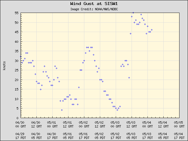
Take a look at the maximum gusts at Smith Island, just upstream of northern Whidbey Island. Twice the gusts reached 55 knots--that's 63 mph.

Keystone Ferry runs were canceled and trees are down all over the island. The fact that many trees have leaves now makes them more vulnerable.

With all the cold and snow lately the snowpack is really doing well. Take a look at the latest plot...and remember we were down to roughly 50% of normal a few weeks ago!
Now everyone is above 75%, Yakima's watershed is above 100% and the Olympics are 140%. You will be able to water your lawn this summer. It is sobering to consider that the National Weather Service's long-range (month ahead) forecast was entirely WRONG about this last few weeks...they were going for warm and dry. The skill of extended forecasts are very low.


Today we had the absolutely best convergence zone you could ask for. Look at these amazing radar and satellite images at around 1 PM. The satellite image shows the classic convergence zone line, with the zones of enhanced clearing to the north and south. One extraordinary aspect of this convergence (and you can see it in the sat picture) is that the convergence zone clouds crossed the Cascades. You don't see that very often.


Here is a high resolution MODIS image at nearly the same time. Amazing...you can see the dust storm in eastern Washington, and the Puget Sound Convergence Zone plume.

I biked home this evening and had to penetrate the convergence zone north of the UW. Lightning was flashing in front of me. I was getting wet. And I could see the clearing on the other side as I turned into my street. Just wonderful.

A Weather Odyssey Across the Cascades

| comments

The Weather Choice On Saturday

One of the most marvelous aspects of our weather are the contrasts on nearly any day with a little driving...and yesterday (Saturday) was no exception.

Yesterday morning there was a cool, unstable air mass over western Washington in the wake of a Pacific front. In western Washington, a cool day with lots of clouds, scattered showers, a Puget Sound convergence zone, and rain on the western slopes beckoned. At roughly 9 AM, the above cam shot at the UW showed the dismal scene (top image). But the satellite image showed another option (see below).

East of the Cascades, as the air descended down the terrain their was profound drying of of the air mass , with sunny skies and some warmth , even though the air mass was fairly cool. My favorite place in such situations is the Vantage/Quincy area... a low region near the Columbia River that is typically sunny under westerly flow. A look at the Silica Road WSDOT cam was promising (see image). The WSDOT cams and weather observations are a real treasure trove for travelers, by the way (http://www.wsdot.wa.gov/traffic/weather/)

My family and I were off around 10:30 AM heading across the Cascades on I90. Dry and cloudy until roughly North Bend, and THEN the weather went bad. With a little lift the atmosphere was destabilized, producing growing cumulus and showers, some very heavy. The weather radar showed some of these windward showers (see below).

Moving up towards Snoqualmie Pass (see cam) it was pretty miserable (see image). 43F and pouring. The showers held on across the Pass and only let up around Easton. But then the sky brightened and east of Cle Elum it started to open up.

But as we moved towards Ellensburg, something else was noticeable--gusts were pushing my car around--and that was expected. With deep cool air moving in from the west, a large pressure difference formed across the mountains. With strong downslope flow and warming east of the Cascades, the pressure had dropped over the eastern Cascade slopes (called a pressure trough) and a large pressure difference was accelerating the flow eastward (see pressure and temperature forecast for 2 PM below). The lines are isobars, lines of constant pressure, and you will notice quite a few of the lines across the mountains.


And I knew that such situations produce another, somewhat unwelcome, feature--strong winds, particularly in the Kittitas Valley area near Ellensburg. There is a reason there are lots of wind farms there. There is a weakness in the Cascades...called the Stampede Gap--and when there are large pressure differences across the Cascades, the air is able to accelerate through this gap into eastern WA (see my book for more information on this). The National Weather Service even had a wind warning up.

When we got to Vantage, there were whitecaps on the river, but the sun was glorious. We headed north a bit (getting off I90 at Silica Road) and stopped for a nice lunch at Cave-B winery/inn near the Gorge Amphitheater (http://www.sagecliffe.com/Inn.htm). Really good view of the river from their restaurant and then we hiked down to the Columbia from the inn. Beautiful day and views, but it was windy! Here is a video I made with my camera:


click on the arrow!

The air temperature was nearly 65F, with winds around 20 kts, with higher gusts, particularly near cliffs or promontories in the terrain. The ground was warm, wild flowers were all over, and the for the trip back to the Inn we passed by a nice waterfall. And then we stopped at their winery's tasting room on the way out. Sun, wind, scenery, the fragrance of sage, and wine....not a bad way to spend the day.

But then there was the two-hour drive back into the clouds.

On the return, the winds had clearly strengthened (typical, due to heating east of the Cascades), with justs to 40 mph near Ellensburg, and a wall of clouds was waiting for us west of Thorp, near the eastern slopes of the Cascades. In addition, lots of dust was rising off some fields east of Ellensburg...some farmer was losing quite a bit of top soil from his/her newly plowed fields. Loss of topsoil is a major problem in eastern Washington and duststorms have caused serious, and sometimes fatal, accidents.

PS: A strange situation is happening right now (Sunday). Rain is spreading over the region...but NOT over Seattle--we are being rainshadowed by the Olympics! The reason...the unusual combination of westerly flow aloft and a wet system.

PSS: As noted in the side bar, I will be talking about local windstorms on Tuesday, at 7:30 PM at McHugh's Irish Bar in Seattle. Shows what I am willing to do for a beer!
 
Support : Creating Website | Johny Template | Mas Template
Copyright © 2011. The Weather - All Rights Reserved
Template Created by Creating Website Published by Mas Template
Proudly powered by Blogger