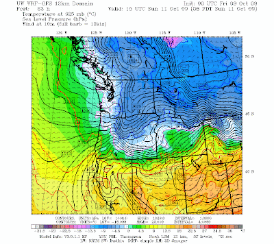

A dry weekend is ahead, but there is some interesting meteorological action in our future. A fairly strong cold front followed by rapidly increasing pressure will push into eastern Washington tomorrow...with several pulses of cold air and high pressure over the weekend. Take a look at several forecast charts over the next few days--they show sea level pressure, surface winds, and temperature (with blue being cold). Notice how the cold colors push in as the cold front moves southward.
This surge of cold air will cause fairly strong winds from the north and northeast...but not as strong as last Sunday. Winds will surely reach 20-30 mph, with some stronger gusts--and such winds are strong enough to raise dust.
The problem is that many farmer's have tilled the soil in preparation for next season, and the ground is very dry. As noted above, it takes a 20-30 mph winds to raise significant dust and we will probably attain this--with the strongest winds probably on Sunday. The Spokane NWS office has already put out a warning for poor visibilities in blowing dust. So be careful if you are driving east of the Cascades this weekend.
If you look carefully at the forecast pressure maps above you will note that there is a tongue of particularly high pressure over the eastern slopes of the Cascades. This is caused by cold-air damming whereby cold air is pushed up over the eastern slopes. Strong easterly winds should also pour out of the Fraser Valley..so Bellingham and NW Washington will also get strong winds. But no dust.


