There's a bird in my radar!

| comments

Weather radar is a great tool for tracking areas of precipitation...but it can see much more. Sometimes it sees birds. In fact, birds are great radar targets, since the amount of radar signal scattered back increases by the sixth power of the diameter of the target...and birds are much bigger than raindrops!

Let me show you an example (see below). Lets go back to April 24th at 8:02 PM (0302 UTC or GMT). The radar is showing little of anything, even though it is in the supersensitive "clear air" mode. A half hour later there is a noticeable increase in the amount of echo (0331 UTC, 8:32 PM PDT), and by 9 PM echoes have really spread and strengthened. This intensification and extension of the radar echoes continued for the next hour.

So did a rainshower move in? Or did a front with rain make landfall? Nope.

The surface observing stations reported dry conditions and generally cloud free skies. It was birds! But why then?

Sunset on that day was 8:12 PM and that is key information. Songbirds like to fly at night (perhaps there are less predators then) and just after sunset they hit the skies for their migration north. And we see this pattern night after night in the spring...and night after night in the fall.

But wait a minute..this is a Doppler radar...we can tell which way they are flying! The Doppler velocity image is shown below for 11 PM. Greens indicate incoming (from the south) and yellows are outgoing (to the north). Thus, with greens south of the radar site (Camano Island) and yellows to the north of the radar, our birds are moving to the north...which makes sense in the spring.

Ornithologists use weather radars for monitoring bird migrations...and now so can you! Imagine when we get a radar on the coast...we will then be able to track the great migrations through Grays Harbor and vicinity. So write or email your Senator and congressman...we need that coastal radar!


Doppler radar below:

An Ocean Full of Low Clouds

| comments


Take a look at the visible satellite picture for northeast Pacific Ocean (see image). Notice anything? Something that is quite different than a few months ago? Something that happens virtually every spring?

The answer:
The ocean is covered for thousands of miles by low stratus/stratocumulus clouds.

We are talking about millions of square miles of low clouds. Every spring we see these low clouds blossom and dominate into summer. And it is the movement of these low clouds into our area during June that produces the familiar June gloom (there are other terms but this is a family-oriented web page). And many of the summer phenomena that I talk about in my book (the onshore push, alongshore surge, etc) are connected with the stratus/stratocumulus of the Pacific.

Why the low clouds? A hint can be found in the surface pressure analysis for this morning at 11 AM (see graphic). A large high pressure area has formed over the northeast Pacific. High pressure is associated with sinking air (called subsidence in the business), and sinking air produces warming aloft since air warms when it is compressed (the air is going from low pressure aloft to higher pressure at lower elevations). The sinking weakens towards the surface since air can't go through the surface! With stronger sinking-warming occurring aloft then near the surface the atmosphere becomes more and more stable--which means there is less tendency for vertical mixing. If you think about it this makes sense, warm air is less dense than colder air...and in nature less dense fluids natural rise above dense ones. This is a stable situation. A dense fluid on top of a less dense one is an unstable configuration.

The stable atmosphere allows moisture to accumulate at low levels, leading to low clouds. Another factor, that is particularly strong near the coasts, is that the high pressure produces northerly winds near the coast, which results in upwelling (see my book for an explanation of this), which brings up cool water. Cool water helps saturate the lower atmosphere....that is why the densest stratus is often along the west coast..particularly central CA.
Anyway, getting back to the story, high pressure builds northward out of the subtropics during the spring and the stratus follows . In the wintertime, as the high retreats and cold air moves in aloft behind Pacific systems, the atmosphere is much better mixed and the low clouds don't form.

So watch the satellite pictures and Pacific pressure patterns...you will note a close association of the low clouds and high pressure areas.

Seattle Math Adoption Decision is Still Up in the Air

PS: I will have an update on the current Seattle high school math situation this week. You won't believe what happened at the school board meeting last week...they split 3-3 and will try again on May 5th. I was amazed that three of them are still considering a terrible math series (Discovering Algebra, Discovery Geometry) that was found by the State Board of Education to be unsuitable. And dropped by San Diego as a failure.

A Cloudy Day West, But Sun East

| comments


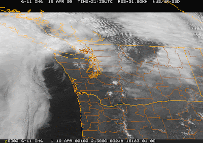
Some people saw some fleeting sunshine this morning..but for most of western Washington, marine cloudiness will rule. Take a look at the visible satellite image this morning. Mostly cloudy from the Pacific to the crest of the Cascades--but generally sunny in eastern Washington. The spring is a great time for a trip east of the Cascades...generally sunny there and the temperatures are quite nice. In winter eastern Washington tends to cool and cloudy, while summer is hot. But grapes like the climate, so I won't complain. The only negative perhaps for eastern Washington this weekend will the winds in Ellensburg and vicinity...but they are used to it.
The current radar shows only a few light, showers ... and most of the them should be on the western slopes of the Cascades. There is a suggestion of a very weak convergence zone north of Seattle..which will probably strengthen later today as an upper trough moves through the region (see satellite image). That upper trough was the initiator of the change this morning.
One indicator of the influx of marine air is the difference in pressure between the coast and the western interior..and the Hoquiam-Seattle difference is probably the most valuable for the Seattle area. (see attached shot of the UW pressure difference web page from last night, times are in UTC/GMT...0000 GMT is 5 PM). If you look carefully, you will see that that difference was negative yesterday (higher pressure inland)...which prevents the marine air from moving in. But that changed later in the afternoon as the pressure difference went positive (marine air moving in). You will also notice the difference across the Cascades (Seattle-Yakima) went very positive....thus air from western Washington is being pushed to the east in any gaps (like the one upstream of Ellensburg). During the summer these pressure differences are crucial for short-term forecasting.Sunday should be better..with more sun and temps getting to around 60 in the lowlands.

Shiptracks!

| comments


During the past several days there have been some odd lines apparent in the visible satellite photos off our coast (see examples). These lines are often seen off the U.S. west coast in thin stratus and stratocumulus cloud decks. Sometimes they look like someone is playing tic-tac-toe over the Pacific. What causes they strange lines? And why was the U.S. Navy concerned about them?

The answer...these are called shiptracks and they result from the particles produced by the combustion in ship engines . But why would smoke and engine effluent cause white lines?
Nearly all low level clouds (such as stratus and stratocumulus) are composed of small water droplets that form on small particles, called condensation nuclei. Over the ocean, where air is clean, there are relatively few of such particles--thus there are relatively few cloud droplets...that grow big and fat since they don't have much competition. But if you add lots of particles from the smokestacks of ships the situation changes greatly...now there are many cloud condensation nuclei and you get a very large number of small drops in the clouds.

It turns out that if you have a certain amount of liquid water in a cloud, the reflective properties of a cloud with lots of small droplets is very different than one with a fewer number of large droplets. Specifically, clouds with more small droplets are more reflective and thus appear whiter from space. The bottom line: the particles from smokestacks cause more reflective clouds. So as the ship moves it leaves a line of whiter, more reflective clouds...the shiptracks you see! These shiptracks move with the wind and eventually get distorted and faded.

Interestingly, with many ships moving across the world's oceans, this effect can add up...even neutralizing a small bit of global warming. And the Navy was quite concerned about shiptracks during the cold war, since enemies could see where U.S. ships were by following the tracks. Fortunately, nuclear ships have no such problem..they have no impact on the clouds.

Temperature, Mountains Wave Clouds, and Math Education in Seattle

| comments


What a difference a day makes. Today was splendid, nearly no clouds, and temperatures reaching the 70s in Puget Sound land and the 80s near Portland (see map above for 5 PM, Monday). In contrast, yesterday was far cooler from Seattle northward. The big reason...an area of clouds produced by mountain waves forced by the Olympics (see satellite picture). In fact, yesterday had spectacular mountain wave cloud downstream of not only the Olympics..but major volcanoes like Mt. Rainier. John Sahr of the UW sent me a wonderful picture of the Rainier wave clouds taken from the east side at Manastash Ridge Observatory, south and west of Ellensburg at about 4000'.


In the satellite picture you can actually see two types of mountain wave clouds. The ones downstream of the Olympics are high in the atmosphere...these are called vertically propagating wave clouds. If look carefully you will see lines of regularly spaced cloud east of the north Cascades..there are trapped lee wave clouds...and are located much lower in the atmosphere. If you want to learn more about these mountain waves, check out my book...I have a whole section on them.

The good weather will hold up one more day...although tomorrow will probably be a few degrees cooler. As shown in the forecast model output below for 8 AM on Wednesday...an energetic cold front will be crossing the area at that time...resulting in the temps on Wed dropping into the 50s, with a few showers as well (nothing serious).
Math Education: Seattle School District is poised to make a big mistake

Finally, a little editorial. Some of you may know that I feel strongly that math education in our state has declined during the past decade or so. Students are coming to the UW without basic competency in math and some wanting to major in atmospheric sciences can't do so because their math background is so poor. Anyway, the Seattle School Board is on the verge of making a huge error in the selection of high school math textbooks...picking the extremely poor "Discovering" Algebra, Discovering Geometry Series by Key Curriculum, which are weak fuzzy/reform math texts. This curricula was found to be “mathematically unsound” by the Washington State Board of Education consultants, and has been removed from the State’s Recommended High School Programs List. Definitions, computational algorithms, and formulas are vaguely stated if they are stated at all. The program does not include enough practice for mastery. Lots of use of calculators. Local and national mathematicians have expressed their written concerns about the soundness of these programs.

The selection was made by the district's math curriculum committee. In contrast, the second place Prentice Hall program, which was favored by a minority of the committee (5 to 8 in committee vote), provides a balanced and content-rich resource for teachers, students, and parents to collaboratively support success. Prentice Hall teaches authentic algebra as recommended by the National Math Advisory Panel and does not include excessive calculator exercises.

The district developed a textbook review process which included no mathematicians and that conflicts with state recommendations and key ideas presented by the National Math Advisory Panel. This is the same process which selected the current elementary and middle school programs, and they have not helped increase student achievement or reduce the achievement gap.

This will be an important vote even if your children are currently in elementary school. You can make a difference by writing a short message to school board directors asking them to reject the district’s program recommendation. FINAL VOTE will be on April 22nd.

School Board Directors:
Michael DeBell - michael.debell@seattleschools.org
Sherry Carr - sherry.carr@seattleschools.org
Harium Martin-Morris - harium.martin-morris@seattleschools.org
Peter Maier - peter.maier@seattleschools.org
Cheryl Chow - cheryl.chow@seattleschools.org
Steve Sundquist - steve.sundquist@seattleschools.org
Mary Bass - mary.bass@seattleschools.org

PS: more information at

www.wheresthemath.com

Watch those soil temperatures!

| comments


Last year I tried to start my vegetable garden from seeds in April...and most of the seeds never germinated.. Well, I did some research on seeds and soil temperatures and found out that the soil temperatures were too cold last year, due to unusually cold spring temperatures. As you remember, last spring was terrible...in some ways the worst (coldest) since 1918. Here are some interesting soil temperature facts.
Most seeds have minimum temperatures that allow germination. And if the temps are close to those minima, germination can be slow or delayed. Some seeds like it cold (peas and parsley can germinate at 40F), while others need warmer temps (cucumber, eggplant and peppers like it hot...60F). My disaster was with beans (which like 50F). And you don't want to know about my tomatoes. So how can you determine the soil temps...well you can stick a thermometer in there (try about 1 inch in)...or there are web sites ...such as the Washington AgWeather network, controlled by WSU (see example above and the web link).
Right now the soil temp of the upper inch or so is approaching 50F in much of western Washington. Want to protect your seedlings and seeds from cold...add mulch. A few inches of mulch can greatly lessen the daily (diurnal temperature range). So it will take out the lows, but also lessen the highs. Cold air tends sink into hollows...so picking a higher location in your yard or even a raised bed can help. And soil temperatures are substantial higher with southern exposures...and particular on the south sides of buildings. Covering your plants with clear plastic..making a small greenhouse... really helps since the plastic lets the sun in, reduces the loss of infrared radiation to space, and lessens the amount of mixing out of warm surface air during the day.
Anyway, time for me to hit the nursery. But a warning...it will be warm on Sunday and Monday, but a cooling trend will develop Tuesday through Thursday. Too cool for tomatoes...which are notorious for being damage by cold. I have found some of the cold-favoring varieties really help.... cliff

PS: I will be at Costco in Kirkland from 11-1 PM signing their books

A weak cold front, then warmth

| comments


The forecast is right on track...and the track is going in the right direction. A weak cold front is now crossing western Washington (see satellite image and radar), with showers now spreading into the region. This evening and the early morning will be wet (see forecast for 4 AM)..with the steady frontal showers finished by midmorning. Then as we are so used to, a Puget Sound convergence zone will form over Snohomish county during the afternoon. Highs in the mid to upper 50s.
Saturday will be the transition day--mostly sunny with temps moving into the lower 60s. But Sunday will be wonderful, sunny with temps reaching into the 70s (see model graphics). And Monday should be the same. It won't last though..with a front and MUCH colder air moving in on Tuesday.

The Upcoming Heat Wave

| comments


So many people are complaining about the cold, unseasonable weather. Even some snow yesterday in the convergence zone! Except for those 3 warm days last week, temps have remained far below normal (see graph). But there is a major change coming this weekend and into next week..and we should see several days reaching the upper 60s and 70s. Take a look at the attached surface temp plots for Friday, Sat, Sun, and Monday at 5 PM--quite a warm up...with Sunday looking torrid...well into the 70s. Even if the model is way off...this is going to be a very warm interval.

Is Sequim Really Sunnier?

| comments

A frequent question is have gotten is about Sequim. Sure it is dry..but is it sunnier. The answer is probably yes..and today (Sunday) is a good example. First start with the weather radar below. World-class rain shadow northeast of the Olympics ! Now look at the high-resolution visible satellite image--and examine it closely. You can see a break in the clouds NE of the Olympics....some sun was clearly getting in there!

Want some ground truth? Look at the cam at the purplehaze lavender farm in Sequim...pretty bright! I have include two other Sequim area cams to show that the ground was dry and there was clearly breaks in the clouds.
Finally, look over the surface chart (the last figure). The winds are plotted at a number of stations (the pennants are pointed in the direction the winds are blowing). Do you see the eddy NE of the Olympics? That is, the winds are going in a circle...with calm winds in the middle. In contrast, the winds are blowing strong from the SE over Whidbey! Sequim means "place of calm waters" in the native american language...and they knew what they were talking about...the wind can be light in the middle of the eddy...thus calming the waters.


PS: I you are interested in going to my lecture on weather and gardening, you must sign up using the link to the right.

| comments


The visible satellite picture today show two things...the clouds on the western side of the Cascades and the approaching weather system offshore. Eastern Washington and Oregon are nearly clear and sunny. We have now switched to the period when eastern Washington no longer clouds in...so very frequently they are clear, when the west side is in clouds. A good time to visit your favorite winery and dry-land hike.

The approaching system is stronger than most this time of the year and the low center will cross northern Vancouver Island (see image for 8 AM tomorrow). It will get breezy later tomorrow am as the low passes north of us, but the big issue will be rain.

The two images that follow show you the predicted 24-h precipitation ending 5 PM tomorrow and Monday. Quite wet tomorrow--with the model going for 2-5 inches on some windward slopes! And a spectacular rainshadow. Head to Sequim tomorrow...somewhere around there may be completely dry...maybe even with some sun breaks. The second day precip is still signficant..but those are mainly showers...with a strong Puget Sound convergence zone (see the next figure for 11 PM on Sunday). Behind the system, temperatures and the snow level will drop...and expect snow..lots of it above 1500 ft (check on the 24h snow ending Monday at 5 AM)

Rain on Sunday (and in Hawaii)

| comments

After three days of above normal temps, we have now switched to a cooler pattern...but the big change will be on Sunday, when heavy rain will probably hit the region....take a look at some of the 24-h rainfall totals from the local high-resolution WRF model for the periods ending 5 PM on Sunday and Monday. The first image shows a nice rainshadow NE of the Olympics and the second a strong Puget Sound convergence zone. A strong warm front will move through late Saturday/early Sunday, with a fairly deep low center passing across northern Vancouver Island.

And if it makes you feel better, Hawaii is getting wet and cloudy weather (see satellite image)...although tomorrow they will 80F with the rain!

The Transition

| comments

The Seattle Profiler shows the transition to marine air very nicely...(image). You can see the easterly and northerly flow on Tuesday)when it was warm and the change to strong southeries and cooler temps as the marine air came in.

The First Push of the Year

| comments


One of the key warm season weather features of the Northwest is the onshore or marine "push"---one of my personal favorites. These events occur following a period of above-average temperatures associated with high pressure inland and offshore flow. The high pressure subsequently moves inland and a weather disturbance approaches from the west, causing an influx of cool, often cloudy, air from off the Pacific.

You know what I am talking about...following a warm day, the winds strengthen and turn to the southwest. Leaves russle and wind chimes ring, and the air become perceptibly cooler. You got to love this. It is the natural air conditioning of western Washington, BC, and Oregon.

Well, a weak version is happening right now. We have had high pressure west of us, providing sunny skies, and warm, offshore flow..with the warming aided by descent down the western slopes of the Cascades (image). The offshore flow helps causing warming and pressure falls (warm air is less dense, thus lower pressure) and the establishment of a "thermal" trough over us (image). Then as the high pressure west of us weakens and a Pacific disturbance approaches, the low "jumps" into eastern Washington and cool air surges inland (image). You can see the cooling...yellows and reds (warm) replaced by greens (cooler).

I have a whole section on this feature in the book if you would like to learn more. One way to see the push happening is to look at the difference in pressure between the coast and the western interior...I like to check out the Hoquiam minus Seattle pressure difference (HQM-SEA). When that gets to around 3-4 mb, you know a major push is underway. You can follow the changing pressure gradients at http://www.atmos.washington.edu/marka/pd.cgi

Onshore pushes happen around a dozen times over a typical summer and usually are very well forecast. This is the first of hopefully many.

By the way, I will be giving a public talk on microclimates and horticulture at the Center for Urban Horticulture next week (April 16)....you can see the details to the right if you are interested...this is a luncheon sponsored by Dunn Gardens and the Seattle Horticultural Associaton.

PS: The governor should be commended for advocating a tuition increase large enough to preserve the core strengths of the state universities. To turn away students or throw away years of building of academic strength would be foolish for both the students and the state.
 
Support : Creating Website | Johny Template | Mas Template
Copyright © 2011. The Weather - All Rights Reserved
Template Created by Creating Website Published by Mas Template
Proudly powered by Blogger