Unusual August Rainfall

| comments


An unusually heavy rainfall event for August is going to strike our region during the next two days, and its coming from the west and northwest--not the usual southwesterly direction of our big winter rains. Take a look at the latest satellite image above--see those clouds offshore?--they are the leading edge of the first a several, unusually strong, late summer disturbances that will strike soon.
How wet? Here are the latest 24-h rainfall total predictions for Washington State ending 5 PM Tuesday and Wednesday (click on the images to get larger images). The coast and western side of the Cascades get hammered, with 1-2 inches being widespread. Some locations may get 2-3.5 inches. The lowlands could receive .5 to 1 inches over the next two days. My advice: you won't have to water for a few days!


Here is the computer forecast of water vapor in the atmosphere (total from the surface to the upper atmosphere) for 11 PM tomorrow. See the extraordinary long plume stretching westward into the Pacific? If that graphic was larger you would see the tail dip down into the subtropics!


Later this week, a ridge of high pressure moves in, the thermal trough moves northward, and we get a few days of warmer weather. But the latest runs suggest it won't last. Sorry. The good thing is that this event will severely damp down the potential for wildfires.

A Change in the Sky

| comments

Yesterday from the Puget Sound Clean Air Agency Visibility Camera

Today from Dale Ireland's web cam

Notice that the sky has a very different look the past two days? Yes, there are clouds...but the clouds have a very different look...with the sky filled with cotton-ball, cumulus type clouds (see above two images). Some of the cumulus have grown into cumulonimbus with rain and lightning (see satellite picture below, particularly over the eastern Cascade slopes)


What has caused these changes? Destablization of the atmosphere. And what has caused that?--moving in of cool air aloft.

There really has been an amazing decline in the lower atmospheric temperatures this week. For example, at roughly 4000 ft...the height of Stevens Pass...the temperatures of the free atmosphere has declined 20F or more from the warm period of a few days ago. With the sun and surface heating still being relatively strong, and cool air moving in aloft, there develops a large change of temperature with height. This destablizes the atmosphere, producing convective mixing, like you see in a saucepan when you cook some oatmeal by turning on the burner.

Tomorrow will be like today, perhaps with more convection over the Cascades. And then things go downhill as a series of system move across the region. Looks like the coast and the southern half of western WA (and Oregon) will get seriously wet as the jet stream dives south of us. I would avoid hiking in the Oregon Cascades for a few days starting late tomorrow unless you are ready for wet stuff.

And keep in mind an important safety issue: the first real rain of the season often produces highly slippery conditions as all the oil that has accumulated during the summer emulsifies with the water. Nasty stuff.

In a future blog I will talk about the upcoming La Nina winter. Hint: this will be a better year to secure an annual ski pass.

Major Change

| comments

For the last few days the weather over the Northwest has been warm and sunny...nearly perfect for outdoor activities. The only negative of the warm, dry weather is fire..and if you look at this evening's visible satellite image you can see the smoke from two large fires over northern Oregon. Plus lots of low clouds along the coast, with a sliver entering the Strait of Juan de Fuca.


Here is a summary of the temperatures of the last 4 weeks versus the normal highs and lows. Pretty normal pattern, with periods of warmer and cooler than normal temps--average out the period, it all is close to normal. There is a good lesson in this--daily temperatures are rarely normal!

A major transition is now occurring and you can expect MUCH cooler weather and the return of some showers for the next 4-5 days. A weak front is now approaching the coast, and the thermal trough, which has been sitting over or just to the east of the western lowlands is rapidly moving eastward. The pressure gradient has turned onshore and cooler air will be moving in overnight. But this will not be like a strong marine push, the decline will be gradual overnight and the first half of Thursday. Here are the pressure patterns for today and tomorrow ... very different indeed.

Aloft the temperatures will be around 20F cooler tomorrow ... you will notice it.

And as the front moves through and the coastal winds turn westerly, a Puget Sound convergence zone will form. As a result the models are predicting a band of precipitation over central Puget Sound late tomorrow afternoon and into the evening (see graphic). Lets see if they are right!

Finally, there have been some ultra-high temps over the inland portions of California, with the warmth extending into Oregon (see graphic). Over 105F in the central valley and over 110F over the SE part of the state. And I might note that nearby Medford, Oregon got to 105F and Redmond, OR a hot 100F! In contrast, the NE U.S. is now cool, with temps in the 70s.

Warm Water in the Cool Northwest

| comments

Want to swim in relatively warm water while staying in the Northwest?

Hit the surf while avoiding that expensive trip to Hawaii?

Its possible. Just like our weather features, local water temperatures also have some interesting variations.

For example, check out the average sea surface temperatures (SSTs) for the last three days for our area:

The warmest temperatures...in the mid 60s!...are found in the inland waters between Vancouver Island and the mainland. Along the Pacific coast the coolest water temperatures are right near the coast, and temperatures warm considerable (into the 60s!) offshore. So cancel that trip to Hawaii...warm water is just a short boat ride away.
Here is a view father down the coast...again, cool water right along the shore and warmer water offshore. You got to go south of Santa Barbara before the coastal sea surface temps become swimable.


So what is going on? A conspiracy against swimming on the Pacific beaches? And why are the inland BC waters so warm?

The reason behind the cool coastal temps is well known...upwelling. During the summer northerly winds dominate along the west coast as the east Pacific anticyclone (high pressure area) strengthens. These winds put a force on the water towards the south. But something else is going on. The turning of the earth produces a Coriolis Force to the right of motion, which in this case creates an offshore (westerly) component to the surface water. Well, if water is moving away from the surface near the coast, some other water has to take its place...water from below. This water is cooler than the surface waters and thus this upward motion (upwelling) causes cooling within tens of km of the coastline. (see my book for a more detailed explanation). The offshore warm water is why many fisherman head west to catch warm-water species (like albacore tuna).

Loads of tuna offshore of the Washington Coast.
Picture courtesy of Ocean Charters in Westport

Coastal BC waters have limited input from the Pacific, are relatively shallow, and get fed by a number rivers, whose waters are relatively warm. That is why many BC people don't feel the need to go to Hawaii. I have been to Hawaii a few times and have never met anyone from BC there, which proves my point.

Relatively warm water is found in some of the large Puget Sound lakes. Take Lake Washington. After a warmer summer period the surface temperature can get into the low 70s. But beware, very cold water is below. Want to see proof? Here are some vertical distributions of temperature (black line) and other parameters from a buoy on Lake Washington. Warm near the surface (20C is 68F) , but head down more than 10 meters (roughly 30 ft) and it gets very cold, very fast.


Of course, high mountain lakes (like Lake Diablo in the N. Cascades) can be much cooler, some in the 40sF. Not good for swimming.

So I hope I have convinced all of you that there is no need to go to Hawaii to enjoy temperate waters. You can send me all the airline tickets to that destination that you won't be using.

Sunday AM

| comments

A brief note---here is the visible sat picture and the latest radar....as predicted by the models a convergence zone has set up, plus clouds/precipitation on the western mountain slopes. SUN is available even on the west side...for example, south of Tacoma there is bright sun right now. Or head east of the crest...get past Easton on I90 and you are out.

It's BACK!

| comments

Rain that is...

During most years there is a weather event during the third week of August that is the harbinger of the fall, when it becomes clear that the summer dry spell is over and cooler temperatures are coming.

Yes, it can still be nice, and often Septembers have spectacular periods around here, but it is not the same.

I am sitting in my home right now, listening to an unaccustomed sound....rain pattering on the roof. Take a look at the latest radar image:


Showers develop over the Olympics during the past few hours and then drifted into central Puget Sound. Its also raining on the north coast, but there isn't any radar coverage to show it (that will change next September!).

A remarkable point about this rain was that the high-resolution numerical models were predicting it well ahead of time--both the start over the Olympics and spreading downstream over central Puget Sound (see graphics). Here are the simulations from Saturday morning showing 3-h rainfall ending 5 and 8 PM:


Tomorrow, the UW WRF model is going for a convergence zone over central Puget Sound and some showers over the mountains (see graphic). The NWS models are doing pretty much the same thing.


Want to be dry? Go north or south of the convergence zone and avoid the western slopes of the Olympics and Cascades. A hike on the eastern slopes of the Cascades will be fine.

Major improvements in store for Monday and Tuesday and things go downhill on Thursday. Guess who planned on outdoor party that night? The weather gods clearly like to keep meteorologists in our place....

The Big Question

| comments


I have repeatedly gotten asked one question--including tonight--so let me answer it for all.

Why is the warmest period of the year in early August, when the sun is strongest on June 21st? How could that be?

Or a similar question: Why are the highest daily temperatures in summer around 5 PM when the sun is strongest at 1 PM (PDT)?
The temperatures should be highest when the sun is the strongest, right?Nope...that isn't correct.

The temperature of the earth depends primarily on two things. The amount of radiation coming IN and the amount of radiation going OUT. Everyone is familiar with what is coming in--radiation from the sun. Nighttime, no solar warming. During the day, the sun's radiation peaks at solar noon (12 PM PST, 1 PM PDT).But there is ALSO radiation going out. That is INFRARED radiation. The earth (and even you) emit infrared radiation. The warmer you are, the more infrared radiation you emit. (no jokes about "hot dates" please). This radiation is going on 24-h a day.

Whether the earth warms up or cools down depends on the sum of what is coming in and what is going out. More coming in than going out...the earth warms. More going out than coming in..the earth cools.

Consider the figure below for the daily situation (standard time). The curve with the yellow fill shows the solar radiation--which of course goes from zero at sunrise and sunset to a maximum at noon. The blue shows the infrared outgoing radiation, which varies as temperature changes. The red line is the temperature. You will notice for a period after noon, the incoming is still greater than the outgoing and thus the air temperature warms. Temperature rises until the outgoing equals the incoming...that is the time of maximum temperature--sometime in the afternoon. (Remember that the amount of infrared radiation depends on temperature, so it is greatest when temperature is highest).
Interestingly the minimum temperature each day often occurs AFTER the sun rises, because it takes a while for the incoming solar warming to exceed the outgoing infrared cooling (see figure).

The same idea works with the annual temperature variation. Yes, the sun is strongest on June 21st, but for a period of time the solar radiation is greater than the outgoing radiation. The crossover is in early August.

And there is something else that influences the time lag between maximum heating and surface temperature..the thermal inertia or heat capacity of the planet: the surface...and particularly water...takes a while to heat up during the summer. Over land, the thermal inertia is relatively small, while for water the thermal inertia is very large. Shallow bodies of water heat up more rapidly than the deep oceans.

Another way to think of all this is to consider you bank account. As long as more money is being deposited than being taken out, your bank balance will increase...even if your deposits are falling off!

Or your bathtub...as long as more water is coming in than draining out, the water level rises.

Makes sense?...let me know if I have confused things even more!

It's Coming!

| comments


The Onshore Push Wind Chime Symphony at 10:30 PM

There are few greater summer pleasures than an onshore push of marine air after a heat wave.

It often starts between 8 and 10 PM. The wind chimes start ringing. Leaves rustle. A comfortable coolness envelopes us. And it is about to happen.

The satellite picture at 6:30 PM shows low clouds are moving inland.

The difference in pressure between Hoquiam and Seattle reached 3.5 mb...enough to guarantee the change.

Update at 9:30 PM. The marine air has pushed past Shelton with a vengeance! Here are the observations for the past few hours:
(click to see better). At 0353 UTC (8:53 PM) Shelton was 57F with winds gusting to 31 knots! Cool air has now reached Tacoma and Bremerton, but has yet to influence the central and northern Sound. But be patient! It is working its way in and should hit Seattle by11 PM.

The latest "fog" imagery shows low clouds now reaching the south Sound and into the Strait (see below). I am cleaning up my wind chimes for the expected chorus in a little while.


Update at 10:30 PM...its here! See my video at the top. It is cooling down fast and one can hear the chimes and winds rustle the leaves.

Rainier Microclimates and Our Cooler Future

| comments

Chinook Pass (5400 ft) 72F

Sunrise 70F
On Saturday my family was looking to get away from the certain heat over the lowlands and a hike in the foothills would have been on the warm side--so I said lets head to Sunrise on Mt. Rainie. (elevation around 6400 ft). My expectation--at least 20 F cooler there and perfect for a pleasant hike (temperature typically decreases by 3.5 F per 1000 ft). Leaving late at 10 AM, I followed the temps from my car thermometer carefully--with warming as I entered the Kent/Auburn/Enumclaw area into the upper 80s. Rainier Area Topo Map: O=Ohanepecosh, S=Sunrise, C=Chinook Pass

But as wegained altitude on RT 410, temperatures began to drop and by the time I got to the White River entrance to the park the temps were in the mid 70s. BIG disappointment followed...the parking lot to Sunrise was so crowded everyone was turned away...so we headed to Chinook Pass for a very nice short hike at Naches Peak, where the temperatures (5500 ft) were in the low 70s. WONDERFUL wildflowers.

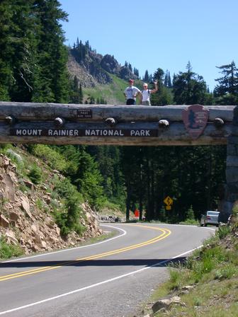
Heading back to Sunrise at 3 PM they let us in and when we reached the 6400 ft high parking lot, the temperature was 70F--at the same time Sea Tac was near 95F. So going high is a good idea on a hot day, but Mt. Rainier also has a notorious hotspot...a great place to go on cool days--particularly cool days with offshore flow--the Ohanepecosh area. I love this place....you can see a very nice water fall (Silver Falls), view the greenish-blue river, check out a hot spring, and visit can ancient trees (Grove of the Patriarchs).
As you can see from the map above, Ohanepecosh is relatively low--within an extension of the valley that passes through Packwood. With offshore flow there is strong sinking into the valley (which brings compressional heating) and it BURNS. This weekend Ohanepecosh was 92F on Saturday and 97F on Sunday! I knew about the heat there and avoided it like the plague.

To show you have good are models are, below is a temperature map for 5 PM Saturday from our super high resolution forecasting system (WRF with 4/3 km grid spacing)....you can see the warm tongue in that valley and the cooler temps immediately to the north where I was.


Today was cooler than expected by the NWS and the media...although they had lots of clues--including the increase in the onshore pressure difference to roughly 2.5 
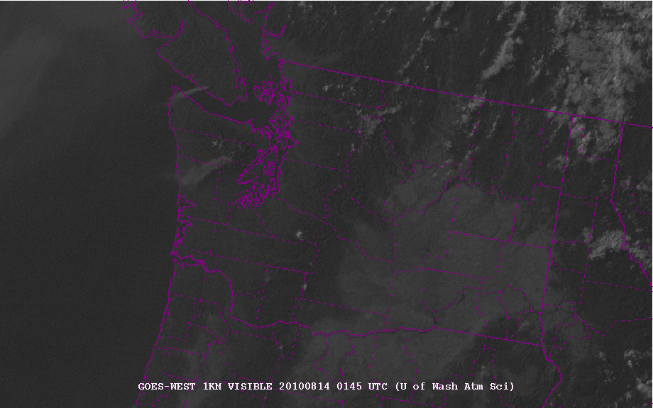
mb late yesterday afternoon and Shelton's vigorous switch to southwesterly during the evening. Today was a nice step down in temperature (5-10F), but unfortunately that pesky BC wildfire smoke came in (image below..can you see the smoke?)

click to make bigger
Tomorrow will be a few degrees cooler, but the big change should be on Wednesday when we will drop back in to the 70s...yes, back to normal. So enjoy the last really warm day for a while. My tomatoes are FINALLY doing well.

Heat Warning

| comments

It is going to be very hot today...in fact, several degrees warmer than some of the forecasts. Many locations in western Washington will get into the mid-90s.
A number of stations...such as Sea Tac...are running ten degrees above yesterday (Sea Tac got to 86 yesterday). The profiler at San Point (Seattle) shows easterly flow aloft and temperatures of roughly 6 C (11F) warmer than yesterday (see plot)

So head for the water if you want to be cool. A good place...the Oregon coast. Stratus and southerly winds have pushed northward up the coast behind the thermal trough, which now is over western Washington (see graphic).


Big contrasts in temps along the Oregon coast (see below)...50s south and near 70F at the WA border at 9 AM...

The Unimaginable: No Clouds--But Smoke is Back!

| comments

UPDATE SAT MORNING: HOT!!
Going to be warm today! Lots of places will be in the lower to mid 90s! Clouds have made their way up the Oregon coast...so go there for cool.

Click on picture for closer view

Above is a NASA MODIS image from this afternoon...something has changed! No low clouds on the coast! The unimaginable has happened. And heat and clear skies will dominate for a while due to offshore (easterly flow). These pictures are really wonderful, with superb resolution. You can see the irrigated lands of eastern Washington and cumulus forming over ridges over the northeast and eastern mountains. You can also see smoke from the BC fires lurking offshore (don't worry, the easterly flow will keep it at bay). Interestingly, all that irrigated land in eastern Washington and elsewhere (like the interior valley of CA) act to cool the surface down by 1-5F. Not enough area to neutralize global warming through.

Unfortunately, the warm easterly winds have helped stoke two new fires...one on the Olympic Peninsula and the other on southern Vancouver Is. Check out this evening visible satellite picture...you can see smoke plumes from both.


Here is the latest forecast for tomorrow at 5 PM..near the time of warmest temps...upper 80s and lower 90s over the lowlands, INCLUDING the coast. Those coastal folks are in for a shock...perhaps a welcome one. Surprising, it may be warmer west of the Cascades than on the eastern side.

Two interesting facts..here in Seattle it is 11F warmer tonight than yesterday at the same time. Second, the dew points are relatively low (50-55F) so the humidity is comfortable.

Finally...Extended Sun and Warmth

| comments

There have been a lot of complaints about the weather lately.

Sure, there has been practically no sun along the coast. Yes, Seattle has had a record-breaking stretch of morning clouds. Sure, most days have not come close to the normal afternoon highs.

But things are going to change, so stock up on ice cream, get some ice ready, and put away those sweaters.

Heat is on the way.

The reason for the change? A substantial change in the large-scale organization of the atmosphere over the eastern Pacific. Earlier in the week am upper-level trough of low pressure was over the Northwest (see graphic) and ridging (high pressure) was well offshore.
The new situation is for the ridge to amplify and move eastward, with no trough dampening our days (next map).


With the amplifying upper level ridge, we will see increased offshore flow and the northward development of the west coast thermally induced trough (TINT). (I have a student working on this feature and we struggled to find a good acronym that was suitable for a family friendly web site).

Want to see the development of the thermal trough? Here is a series of maps with surface winds, sea level pressure, and lower atmospheric temperatures.

Thursday at 5 PM-thermal trough extending into southern Oregon!

Friday at 5 PM thermal trough into southern WA. Note the easterly offshore flow on the WA cascades

Saturday at 5 PM. Thermal trough into NW Washington. Offshore flow moving offshore. No clouds on the WA coast! AMAZING!
Sunday at 5 PM. Thermal trough even stronger and temps warmer still!

Tomorrow will be beautiful and near 80F, Friday in the mid 80s, Saturday and Sunday can see upper 80s to lower 90s. The Willamette Valley will be much warmer. Why? Far less influence of marine air in that enclosed valley.

Diablo Winds in the North Cascades and the Upcoming Heat Wave!

| comments


An green-blue mountain lake with towering mountains, snowfields and glaciers, as well as a fascinating meteorology--the is what I found during a pleasant stay this weekend at the North Cascade Institute, where I was one of the instructors for their Naturalist Weekend Retreat. The location of this beautiful facility is on Diablo Lake (see maps above and below), behind City Light's Diablo Dam. A very pleasant place to take environmentally oriented classes or to use as a base for exploring the North Cascades.


The lake (see picture below) has a green-bluish tinge due to the very fine particles produced by the surrounding glaciers (glacial flour). Why greenish blue? Why is the sky blue? A similar reason--what is known as Rayleigh scattering of visible light. Very fine particles scatter short wavelengths (like blue or green) far more than longer wavelengths (like red or yellow). Thus the shorter wavelengths are scattered back to your eye producing the bluish or greenish tint.

Some of the most exceptional meteorological features of this location are the diurnal (daily) winds. Nearly every day in summer the winds pick up on the lake around noon, with the flow accelerating up to 12-25 mph, often producing whitecaps. The wind is from the west, flowing directly up the Skagit River valley (see map above). During my stay I noted a strong correlation between this westerly wind and the pressure difference across the Cascades; when eastern Washington pressure fell relative to the west, the winds accelerated. Thus, the winds appeared to be gap winds, which are roughly proportional to the pressure difference across the gap. The interesting thing for me, is although the gap is very clear to the west (the Skagit River Valley), to the immediate east there is considerable blocking terrain until one gets to Mazama. But clearly the air rushing up the Skagit is going somewhere as it pushes to the east. Since the pressure difference increases during the day (eastern Washington heats up, air there becomes less dense, and thus the pressure falls), the wind strengthened late morning into the afternoon.

Want to see a video of the winds that I took from an overlook above the eastern side of Diablo Lake? Check this out:


Those trees are permanently deformed by the strong westerly winds!

Another interesting feature includes the rainfall and clouds. There is a very large precipitation gradient across this area. At Diablo and Ross dams they typically get about 57 inches a year, yet at Newhalem, the City Light company town a few miles to the west, there is usually about 79 inches. And far more in the mountains to the west. You can frequently see the clouds breaking to the east of the mountains west of Diablo Dam (see my marked up picture). That really makes that area far less cloudy than the windward slopes of the north Cascades.


The basin surrounding Diablo Lake is home to an extraordinary number of glaciers and of course State Route 20 is famous for its wintertime snow closures. It only has been able to stay open for one winter- the amazingly dry winter of 1976-1977.

Finally, let me talk about current weather. We had some showers and clouds today, but don't worry...a BIG change is coming later this week. Sun and warmth will return on Friday and expect the 80s this weekend. Don't listen to those who tell you summer is over...it is not.
 
Support : Creating Website | Johny Template | Mas Template
Copyright © 2011. The Weather - All Rights Reserved
Template Created by Creating Website Published by Mas Template
Proudly powered by Blogger